FAA INFORMATION EFFECTIVE 16 APRIL 2026
Location
| FAA Identifier: | 3R7 |
| Lat/Long: | 30-14-33.7165N 092-40-24.5974W
30-14.561942N 092-40.409957W
30.2426990,-92.6734993
(estimated) |
| Elevation: | 22.8 ft. / 6.9 m (surveyed) |
| Variation: | 02E (2005) |
| From city: | 1 mile NW of JENNINGS, LA |
| Time zone: | UTC -5 (UTC -6 during Standard Time) |
| Zip code: | 70546 |
Airport Operations
| Airport use: | Open to the public |
| Activation date: | 09/1945 |
| Control tower: | no |
| ARTCC: | HOUSTON CENTER |
| FSS: | DE RIDDER FLIGHT SERVICE STATION |
| NOTAMs facility: | DRI (NOTAM-D service available) |
| Attendance: | MON-FRI 0600-1600 |
| Wind indicator: | lighted |
| Segmented circle: | no |
| Lights: | ACTVT MIRL RWY 08/26, RWY 13/31 - CTAF. |
| Beacon: | white-green (lighted land airport)
Operates sunset to sunrise. |
Airport Communications
| CTAF/UNICOM: | 122.8 |
| WX AWOS-3PT: | 121.150 (337-824-0517) |
| LAKE CHARLES APPROACH: | 119.8 |
| LAKE CHARLES DEPARTURE: | 119.8 |
- APCH/DEP SVC PRVDD BY HOUSTON ARTCC (ZHU) ON FREQS 124.7/317.4 (LAKE CHARLES RCAG) WHEN LAKE CHARLES APCH CTL (LCH) CLSD.
Nearby radio navigation aids
| VOR radial/distance | | VOR name | | Freq | | Var |
|---|
| LCHr068/23.2 | | LAKE CHARLES VORTAC | | 113.40 | | 07E |
| LFTr272/35.4 | | LAFAYETTE VORTAC | | 109.80 | | 03E |
| LLAr332/38.1 | | WHITE LAKE VOR/DME | | 114.95 | | 04E |
| NDB name | | Hdg/Dist | | Freq | | Var | | ID |
|---|
| ABBEVILLE | | 289/30.6 | | 230 | | 02E | | BNZ | -... -. --.. |
| SULPHUR | | 082/38.8 | | 278 | | 04E | | AUR | .- ..- .-. |
Airport Services
| Fuel available: | 100LL JET-A
100LL:SELF SERVICE FUEL AVBL AFT HRS WITH CREDIT CARD. |
| Parking: | hangars and tiedowns |
| Bottled oxygen: | NONE |
| Bulk oxygen: | NONE |
Runway Information
Runway 8/26
| Dimensions: | 5002 x 75 ft. / 1525 x 23 m |
| Surface: | asphalt, in excellent condition |
| Weight bearing capacity: | |
| Runway edge lights: | medium intensity |
| RUNWAY 8 | | RUNWAY 26 |
| Latitude: | 30-14.544043N | | 30-14.696737N |
| Longitude: | 092-41.141017W | | 092-40.207102W |
| Elevation: | 16.6 ft. | | 20.0 ft. |
| Traffic pattern: | left | | right |
| Runway heading: | 077 magnetic, 079 true | | 257 magnetic, 259 true |
| Markings: | nonprecision, in good condition | | nonprecision, in good condition |
| Visual slope indicator: | 2-light PAPI on left (3.00 degrees glide path) | | 2-light PAPI on left (3.00 degrees glide path) |
| Runway end identifier lights: | yes | | yes |
| Touchdown point: | yes, no lights | | yes, no lights |
| Obstructions: | 36 ft. trees, 1256 ft. from runway, 1246 ft. left of centerline, 29:1 slope to clear | | 37 ft. pole, marked and lighted, 1407 ft. from runway, 32:1 slope to clear |
Runway 13/31
| Dimensions: | 3601 x 75 ft. / 1098 x 23 m |
| Surface: | asphalt, in excellent condition |
| Weight bearing capacity: | |
| Runway edge lights: | medium intensity |
| RUNWAY 13 | | RUNWAY 31 |
| Latitude: | 30-14.695130N | | 30-14.274983N |
| Longitude: | 092-40.471495W | | 092-39.987690W |
| Elevation: | 18.1 ft. | | 22.8 ft. |
| Traffic pattern: | right | | left |
| Runway heading: | 133 magnetic, 135 true | | 313 magnetic, 315 true |
| Displaced threshold: | no | | 588 ft. |
| Markings: | basic, in good condition | | basic, in good condition |
| Visual slope indicator: | 2-light PAPI on left (3.00 degrees glide path) | | 2-light PAPI on left (3.00 degrees glide path) |
| Runway end identifier lights: | yes | | yes |
| Touchdown point: | yes, no lights | | yes, no lights |
| Obstructions: | 30 ft. sign, lighted, 827 ft. from runway, 110 ft. right of centerline, 21:1 slope to clear | | 17 ft. bldg, 396 ft. from runway, 109 ft. left of centerline, 11:1 slope to clear
5 FT FENCE & +15 FT ROAD 140 FT FM EOR. |
Runway 17/35
| Dimensions: | 1977 x 150 ft. / 603 x 46 m |
| Surface: | turf, in good condition |
| Runway edge markings: | RWY 17/35 AND THLD OUTLINED WITH ORANGE CONES. |
| RUNWAY 17 | | RUNWAY 35 |
| Latitude: | 30-14.717138N | | 30-14.391063N |
| Longitude: | 092-40.069203W | | 092-40.071340W |
| Elevation: | 21.5 ft. | | 21.6 ft. |
| Traffic pattern: | right | | left |
| Runway heading: | 178 magnetic, 180 true | | 358 magnetic, 000 true |
| Markings: | none, in fair condition | | none, in fair condition |
| Touchdown point: | yes, no lights | | yes, no lights |
| Obstructions: | 35 ft. pole, 682 ft. from runway, 19:1 slope to clear | | 40 ft. pline, lighted, 1200 ft. from runway, 30:1 slope to clear |
Airport Ownership and Management from official FAA records
| Ownership: | Publicly-owned |
| Owner: | JEFFERSON DAVIS PARISH
ARPT COMMISSION DIST NR 1, P.O.BOX 745
JENNINGS, LA 70546
Phone 337-824-1567 |
| Manager: | DWAYNE BEBEE
P.O.BOX 877
JENNINGS, LA 70546
Phone 337-616-2370 |
Additional Remarks
| - | 20 FT UNLGTD TWR 150 FT FM AER 35. |
| - | ULTRALIGHT ACTVTY INVOF ARPT. |
| - | NMRS AGRICULTURAL ACFT INVOF ARPT. |
| - | FOR CD CTC HOUSTON ARTCC AT 281-230-5622. |
| - | CTC ARPT MGR FOR RAMP SPACE DSNGD FOR PUB USE AT ARPT |
Instrument Procedures
NOTE: All procedures below are presented as PDF files. If you need a reader for these files, you should download the free Adobe Reader.NOT FOR NAVIGATION. Please procure official charts for flight.
FAA instrument procedures published for use from 16 April 2026 at 0901Z to 14 May 2026 at 0900Z.
IAPs - Instrument Approach Procedures |
|---|
| RNAV (GPS) RWY 08 **CHANGED** | |
download (209KB) |
| RNAV (GPS) RWY 26 **CHANGED** | |
download (236KB) |
| NOTE: Special Alternate Minimums apply | |
download |
| NOTE: Special Take-Off Minimums/Departure Procedures apply | |
download (299KB) |
Other nearby airports with instrument procedures:
6R1 - Welsh Airport (8 nm W)
4R7 - Eunice Airport (19 nm NE)
KCWF - Chennault International Airport (24 nm W)
KLCH - Lake Charles Regional Airport (29 nm W)
KACP - Allen Parish Airport (30 nm N)
|
|

Road maps at:
MapQuest
Bing
Google
| Aerial photo |
|---|
WARNING: Photo may not be current or correct
 Photo by Tim Cushenberry
Photo taken 18-Jan-2006
Photo by Tim Cushenberry
Photo taken 18-Jan-2006
Do you have a better or more recent aerial photo of Jennings Airport that you would like to share? If so, please send us your photo.
|
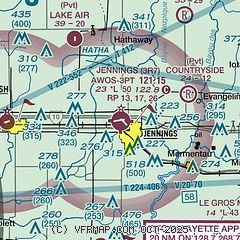
| Sectional chart |
|---|
|
| Airport distance calculator |
|---|
|
|
| Sunrise and sunset |
|---|
|
Times for 21-Apr-2026
| | Local
(UTC-5) | | Zulu
(UTC) |
|---|
| Morning civil twilight | | 06:13 | | 11:13 |
| Sunrise | | 06:38 | | 11:38 |
| Sunset | | 19:41 | | 00:41 |
| Evening civil twilight | | 20:06 | | 01:06 |
|
| Current date and time |
|---|
| Zulu (UTC) | 21-Apr-2026 06:39:01 |
|---|
| Local (UTC-5) | 21-Apr-2026 01:39:01 |
|---|
|
| METAR |
|---|
| K3R7 | 210615Z AUTO 11003KT 10SM CLR 16/14 A3024 RMK AO2 T01640135
|
|
| TAF |
|---|
KLCH
29nm W | 210520Z 2106/2206 VRB04KT P6SM BKN250 FM211400 11010KT P6SM OVC100 FM211600 10008KT P6SM BKN070 PROB30 2118/2124 4SM -SHRA BR OVC025 FM220100 11007KT P6SM OVC100
|
KLFT
35nm E | 210520Z 2106/2206 VRB03KT P6SM BKN250 FM212200 15007KT P6SM VCSH BKN250 FM220000 16005KT P6SM OVC100
|
|
| NOTAMs |
|---|
NOTAMs are issued by the DoD/FAA and will open in a separate window not controlled by AirNav.
|
|


