FAA INFORMATION EFFECTIVE 16 APRIL 2026
Location
| FAA Identifier: | 6R1 |
| Lat/Long: | 30-14-30.6764N 092-49-50.6580W
30-14.511273N 092-49.844300W
30.2418546,-92.8307383
(estimated) |
| Elevation: | 18 ft. / 5.5 m (surveyed) |
| Variation: | 07E (1965) |
| Time zone: | UTC -5 (UTC -6 during Standard Time) |
| Zip code: | 70591 |
Airport Operations
| Airport use: | Open to the public |
| Activation date: | 10/1947 |
| Control tower: | no |
| ARTCC: | HOUSTON CENTER |
| FSS: | DE RIDDER FLIGHT SERVICE STATION |
| NOTAMs facility: | DRI (NOTAM-D service available) |
| Attendance: | IREG |
| Wind indicator: | lighted |
| Segmented circle: | no |
| Lights: | SS-SR |
| Beacon: | white-green (lighted land airport)
Operates sunset to sunrise. |
Airport Communications
| CTAF/UNICOM: | 122.8 |
| LAKE CHARLES APPROACH: | 119.8 |
| LAKE CHARLES DEPARTURE: | 119.8 |
| WX AWOS-3PT at 3R7 (8 nm E): | 121.150 (337-824-0517) |
| WX AWOS-3 at CWF (16 nm W): | 120.0 (337-214-2134) |
- APCH/DEP SVC PRVDD BY HOUSTON ARTCC (ZHU) ON FREQS 124.7/317.4 (LAKE CHARLES RCAG) WHEN LAKE CHARLES APCH CTL (LCH) CLSD.
Nearby radio navigation aids
| VOR radial/distance | | VOR name | | Freq | | Var |
|---|
| LCHr060/15.5 | | LAKE CHARLES VORTAC | | 113.40 | | 07E |
| NDB name | | Hdg/Dist | | Freq | | Var | | ID |
|---|
| SULPHUR | | 081/30.7 | | 278 | | 04E | | AUR | .- ..- .-. |
| ABBEVILLE | | 284/38.3 | | 230 | | 02E | | BNZ | -... -. --.. |
Airport Services
| Airframe service: | NONE |
| Powerplant service: | NONE |
| Bottled oxygen: | NONE |
| Bulk oxygen: | NONE |
Runway Information
Runway 7/25
| Dimensions: | 2700 x 50 ft. / 823 x 15 m |
| Surface: | asphalt, in fair condition
RWY HAS SOME SMALL LONGITUDINAL CRACKS WITH GRASS GROWTH. BLOCK CRACKS WITH GRASS GROWTH RWY 07 TURNAROUND. GRAVEL FOD PRESENT IN PLACES. |
| Weight bearing capacity: | |
| Runway edge lights: | medium intensity |
| RUNWAY 7 | | RUNWAY 25 |
| Latitude: | 30-14.479750N | | 30-14.619783N |
| Longitude: | 092-50.137817W | | 092-49.651317W |
| Elevation: | 18.0 ft. | | 18.0 ft. |
| Traffic pattern: | left | | left |
| Runway heading: | 065 magnetic, 072 true | | 245 magnetic, 252 true |
| Markings: | basic, in fair condition | | basic, in fair condition |
| Touchdown point: | yes, no lights | | yes, no lights |
| Obstructions: | 57 ft. trees, 1137 ft. from runway, 253 ft. right of centerline, 16:1 slope to clear | | 67 ft. trees, 953 ft. from runway, 131 ft. left of centerline, 11:1 slope to clear |
Runway 9/27
| Dimensions: | 2200 x 150 ft. / 671 x 46 m |
| Surface: | turf, in fair condition |
| RUNWAY 9 | | RUNWAY 27 |
| Latitude: | 30-14.462400N | | 30-14.465667N |
| Longitude: | 092-49.992050W | | 092-49.573167W |
| Elevation: | 18.0 ft. | | 18.0 ft. |
| Traffic pattern: | left | | left |
| Runway heading: | 082 magnetic, 089 true | | 262 magnetic, 269 true |
| Markings: | none, in fair condition | | none, in fair condition |
| Obstructions: | 55 ft. trees, 204 ft. from runway, 125 ft. right of centerline, 4:1 slope to clear | | 51 ft. trees, 367 ft. from runway, 59 ft. right of centerline, 7:1 slope to clear |
Airport Ownership and Management from official FAA records
| Ownership: | Publicly-owned |
| Owner: | CITY OF WELSH
PO BOX 786
WELSH, LA 70591
Phone 318-734-2231 |
| Manager: | KARL ARCENEAUX
PO BOX 863
WELSH, LA 70591
Phone 337-570-4590 |
Additional Remarks
| - | TWY FM HGR TO END OF RY 25. |
| - | FOR CD CTC LAKE CHARLES APCH AT 337-480-3103, WHEN APCH CLSD CTC HOUSTON ARTCC AT 281-230-5622. |
| - | CTC APRT MGR FOR DSGND RAMP SPACE FOR PUB USE. |
Instrument Procedures
NOTE: All procedures below are presented as PDF files. If you need a reader for these files, you should download the free Adobe Reader.NOT FOR NAVIGATION. Please procure official charts for flight.
FAA instrument procedures published for use from 16 April 2026 at 0901Z to 14 May 2026 at 0900Z.
IAPs - Instrument Approach Procedures |
|---|
| VOR/DME OR GPS RWY 07 | |
download (179KB) |
| NOTE: Special Take-Off Minimums/Departure Procedures apply | |
download (302KB) |
Other nearby airports with instrument procedures:
3R7 - Jennings Airport (8 nm E)
KCWF - Chennault International Airport (16 nm W)
KLCH - Lake Charles Regional Airport (22 nm W)
4R7 - Eunice Airport (25 nm NE)
KUXL - Southland Field Airport (29 nm W)
|
|

Road maps at:
MapQuest
Bing
Google
| Aerial photo |
|---|
WARNING: Photo may not be current or correct
 Photo by Tim Cushenberry
Photo taken 18-Jan-2006
looking north
Photo by Tim Cushenberry
Photo taken 18-Jan-2006
looking north
Do you have a better or more recent aerial photo of Welsh Airport that you would like to share? If so, please send us your photo.
|
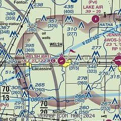
| Sectional chart |
|---|
|
| Airport distance calculator |
|---|
|
|
| Sunrise and sunset |
|---|
|
Times for 03-May-2026
| | Local
(UTC-5) | | Zulu
(UTC) |
|---|
| Morning civil twilight | | 06:02 | | 11:02 |
| Sunrise | | 06:27 | | 11:27 |
| Sunset | | 19:49 | | 00:49 |
| Evening civil twilight | | 20:15 | | 01:15 |
|
| Current date and time |
|---|
| Zulu (UTC) | 03-May-2026 05:46:54 |
|---|
| Local (UTC-5) | 03-May-2026 00:46:54 |
|---|
|
| METAR |
|---|
K3R7
8nm E | 030535Z AUTO 00000KT 10SM CLR 14/11 A3014 RMK AO2 T01350105
|
KCWF
17nm W | 030535Z AUTO 00000KT 10SM CLR 14/11 A3014 RMK AO2 T01380108
|
|
| TAF |
|---|
KLCH
21nm W | 021720Z 0218/0318 03013G21KT P6SM SKC FM030000 03007KT P6SM SKC FM030600 00000KT P6SM SKC FM031300 VRB04KT P6SM SKC
|
|
| NOTAMs |
|---|
NOTAMs are issued by the DoD/FAA and will open in a separate window not controlled by AirNav.
|
|

