FAA INFORMATION EFFECTIVE 16 APRIL 2026
Location
| FAA Identifier: | 3TA |
| Lat/Long: | 37-57-30.0540N 098-39-01.3030W
37-57.500900N 098-39.021717W
37.9583483,-98.6503619
(estimated) |
| Elevation: | 1886 ft. / 574.9 m (surveyed) |
| Variation: | 08E (1985) |
| From city: | 3 miles W of STAFFORD, KS |
| Time zone: | UTC -5 (UTC -6 during Standard Time) |
| Zip code: | 67578 |
Airport Operations
| Airport use: | Open to the public |
| Activation date: | 12/1945 |
| Control tower: | no |
| ARTCC: | KANSAS CITY CENTER |
| FSS: | WICHITA FLIGHT SERVICE STATION |
| NOTAMs facility: | ICT (NOTAM-D service available) |
| Attendance: | UNATNDD |
| Wind indicator: | lighted |
| Segmented circle: | no |
| Beacon: | white-green (lighted land airport)
Operates sunset to sunrise. |
Airport Communications
| CTAF: | 122.9 |
| WX AWOS-3PT at PTT (16 nm S): | 118.725 (620-672-2793) |
Nearby radio navigation aids
| VOR radial/distance | | VOR name | | Freq | | Var |
|---|
| HUTr262/34.0 | | HUTCHINSON VOR/DME | | 116.80 | | 04E |
Airport Services
| Parking: | hangars and tiedowns |
| Airframe service: | NONE |
| Powerplant service: | NONE |
| Bottled oxygen: | NONE |
| Bulk oxygen: | NONE |
Runway Information
Runway 17/35
| Dimensions: | 2560 x 100 ft. / 780 x 30 m |
| Surface: | turf, in good condition
FIRST 1200 FT OF RY 35 SOFT & WET AFTER RAIN. |
| Runway edge lights: | low intensity |
| RUNWAY 17 | | RUNWAY 35 |
| Latitude: | 37-57.735333N | | 37-57.313500N |
| Longitude: | 098-38.800833W | | 098-38.801000W |
| Traffic pattern: | left | | left |
| Obstructions: | 15 ft. road, 15 ft. from runway
CONTROLLING OBSTN EXCEEDS A 45 DEG SLP. | | 15 ft. road, 50 ft. from runway, 3:1 slope to clear |
Runway 13/31
| Dimensions: | 1900 x 80 ft. / 579 x 24 m |
| Surface: | turf, in good condition
FIRST 700 FT OF RY 31 WET & SOFT AFTER RAIN. |
| RUNWAY 13 | | RUNWAY 31 |
| Traffic pattern: | left | | left |
| Obstructions: | 30 ft. bldg, marked, 20 ft. from runway, 80 ft. left of centerline
CONTROLLING OBSTN EXCEEDS A 45 DEG SLP. | | 15 ft. road, 175 ft. from runway, 11:1 slope to clear |
Runway 3/21
| Dimensions: | 1580 x 260 ft. / 482 x 79 m |
| Surface: | turf, in good condition |
| RUNWAY 3 | | RUNWAY 21 |
| Latitude: | 37-57.545500N | | 37-57.721167N |
| Longitude: | 098-39.031500W | | 098-38.788667W |
| Traffic pattern: | left | | left |
| Obstructions: | none | | 15 ft. road, 51 ft. from runway, 3:1 slope to clear |
Airport Ownership and Management from official FAA records
| Ownership: | Publicly-owned |
| Owner: | CITY OF STAFFORD
112 W. BROADWAY, BOX 280
STAFFORD, KS 67578
Phone (620) 234-5011 |
| Manager: | SHAWN BURGEY
112 W. BROADWAY, BOX 280
STAFFORD, KS 67578
Phone (620) 234-5011 |
Additional Remarks
| - | FOR CD CTC KANSAS CITY ARTCC AT 913-254-8508. |
Instrument Procedures
There are no published instrument procedures at 3TA.
Some nearby airports with instrument procedures:
KPTT - Pratt Regional Airport (16 nm S)
KGBD - Great Bend Municipal Airport (25 nm NW)
KLQR - Larned-Pawnee County Airport (25 nm NW)
KLYO - Lyons-Rice County Municipal Airport (30 nm NE)
9K8 - Kingman Airport/Clyde Cessna Field (30 nm SE)
|
|

Road maps at:
MapQuest
Bing
Google
| Aerial photo |
|---|
WARNING: Photo may not be current or correct
 Photo by Von Rothenberger
Photo taken 03-Sep-2010
looking east.
Photo by Von Rothenberger
Photo taken 03-Sep-2010
looking east.
Do you have a better or more recent aerial photo of Stafford Municipal Airport that you would like to share? If so, please send us your photo.
|
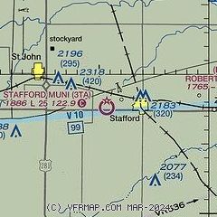
| Sectional chart |
|---|
|
| Airport distance calculator |
|---|
|
|
| Sunrise and sunset |
|---|
|
Times for 09-May-2026
| | Local
(UTC-5) | | Zulu
(UTC) |
|---|
| Morning civil twilight | | 06:02 | | 11:02 |
| Sunrise | | 06:31 | | 11:31 |
| Sunset | | 20:31 | | 01:31 |
| Evening civil twilight | | 21:00 | | 02:00 |
|
| Current date and time |
|---|
| Zulu (UTC) | 09-May-2026 12:29:30 |
|---|
| Local (UTC-5) | 09-May-2026 07:29:30 |
|---|
|
| METAR |
|---|
KPTT
16nm S | 091215Z AUTO 23005KT 10SM CLR 12/07 A2987 RMK AO2 T01200073
|
KLQR
25nm NW | 091215Z AUTO 24008KT 10SM CLR 12/05 A2985 RMK AO2
|
KGBD
26nm NW | 091156Z AUTO 23011KT 10SM FEW120 12/04 A2985 RMK AO2 SLP099 T01170039 10117 20094 55001 $
|
KLYO
30nm NE | 091215Z AUTO 25003KT 10SM CLR 11/05 A2986 RMK AO2 T01110054
|
|
| TAF |
|---|
KGBD
26nm NW | 091121Z 0912/1012 22008KT P6SM FEW200 FM091500 22014KT P6SM SCT200 PROB30 0922/1002 5SM -TSRA BKN070CB FM100200 05010KT P6SM BKN100
|
|
| NOTAMs |
|---|
NOTAMs are issued by the DoD/FAA and will open in a separate window not controlled by AirNav.
|
|


