FAA INFORMATION EFFECTIVE 09 JULY 2026
Location
| FAA Identifier: | 3U8 |
| Lat/Long: | 48-09-48.3691N 110-06-51.4219W
48-09.806152N 110-06.857032W
48.1634359,-110.1142839
(estimated) |
| Elevation: | 2698.5 ft. / 822.5 m (surveyed) |
| Variation: | 16E (1985) |
| From city: | 1 mile S of BIG SANDY, MT |
| Time zone: | UTC -6 (UTC -7 during Standard Time) |
| Zip code: | 59520 |
Airport Operations
| Airport use: | Open to the public |
| Activation date: | 10/1949 |
| Control tower: | no |
| ARTCC: | SALT LAKE CITY CENTER |
| FSS: | GREAT FALLS FLIGHT SERVICE STATION |
| NOTAMs facility: | GTF (NOTAM-D service available) |
| Attendance: | ON CALL ON CALL ON CALL |
| Pattern altitude: | 3498.5 ft. MSL |
| Wind indicator: | lighted |
| Segmented circle: | yes |
| Lights: | ACTVT MIRL RWY 06/24 - CTAF. |
| Beacon: | white-green (lighted land airport)
Operates sunset to sunrise. |
Airport Communications
Nearby radio navigation aids
| VOR radial/distance | | VOR name | | Freq | | Var |
|---|
| HVRr195/26.5 | | HAVRE VOR/DME | | 114.65 | | 16E |
Airport Services
| Fuel available: | 100LL |
| Parking: | hangars and tiedowns |
| Airframe service: | NONE |
| Powerplant service: | NONE |
| Bottled oxygen: | NONE |
| Bulk oxygen: | NONE |
Runway Information
Runway 6/24
| Dimensions: | 3570 x 60 ft. / 1088 x 18 m |
| Surface: | asphalt, in excellent condition |
| Weight bearing capacity: | | PCN 5 /F/D/Z/U | | Single wheel: | 12.5 |
|
| Runway edge lights: | medium intensity |
| RUNWAY 6 | | RUNWAY 24 |
| Latitude: | 48-09.716333N | | 48-09.858500N |
| Longitude: | 110-07.436833W | | 110-06.585500W |
| Elevation: | 2689.7 ft. | | 2697.2 ft. |
| Traffic pattern: | left | | left |
| Markings: | basic, in good condition | | basic, in good condition |
| Visual slope indicator: | 2-light PAPI on left (3.00 degrees glide path) | | 2-light PAPI on left (3.00 degrees glide path) |
| Obstructions: | none | | 15 ft. road, 670 ft. from runway, 31:1 slope to clear |
Runway 13/31
| Dimensions: | 2100 x 100 ft. / 640 x 30 m |
| Surface: | turf, in good condition |
| RUNWAY 13 | | RUNWAY 31 |
| Latitude: | 48-09.982167N | | 48-09.693833N |
| Longitude: | 110-06.737000W | | 110-06.453000W |
| Elevation: | 2697.0 ft. | | 2698.5 ft. |
| Traffic pattern: | left | | left |
| Runway heading: | 131 magnetic, 147 true | | 311 magnetic, 327 true |
| Touchdown point: | yes, no lights | | yes, no lights |
| Obstructions: | 71 ft. pline, marked, 1600 ft. from runway, 22:1 slope to clear
PWR LN MKD WITH ORANGE BALLS. | | 15 ft. road, 650 ft. from runway, 43:1 slope to clear |
Airport Ownership and Management from official FAA records
| Ownership: | Publicly-owned |
| Owner: | BIG SANDY/CCJAB
1026 PRAIRIE DOG LANE
BIG SANDY, MT 59520
Phone (406) 390-3910 |
| Manager: | JOE ESSERT
1026 PRAIRIE DOG LANE
BIG SANDY, MT 59520
Phone 970-222-5191 |
Additional Remarks
| - | FOR CD CTC SALT LAKE ARTCC AT 801-320-2568. |
Instrument Procedures
There are no published instrument procedures at 3U8.
Some nearby airports with instrument procedures:
KHVR - Havre City-County Airport (27 nm NE)
79S - Fort Benton Airport (28 nm SW)
S64 - Stanford Airport/Biggerstaff Field (61 nm S)
KGTF - Great Falls International Airport (65 nm SW)
KLWT - Lewistown Municipal Airport (72 nm S)
|
|

Road maps at:
MapQuest
Bing
Google
| Aerial photo |
|---|

|
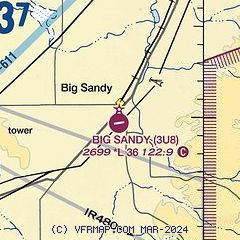
| Sectional chart |
|---|
|
| Airport distance calculator |
|---|
|
|
| Sunrise and sunset |
|---|
|
Times for 25-Jul-2026
| | Local
(UTC-6) | | Zulu
(UTC) |
|---|
| Morning civil twilight | | 05:11 | | 11:11 |
| Sunrise | | 05:48 | | 11:48 |
| Sunset | | 21:06 | | 03:06 |
| Evening civil twilight | | 21:43 | | 03:43 |
|
| Current date and time |
|---|
| Zulu (UTC) | 26-Jul-2026 02:59:42 |
|---|
| Local (UTC-6) | 25-Jul-2026 20:59:42 |
|---|
|
| METAR |
|---|
KHVR
27nm NE | 260253Z AUTO 24012G28KT 10SM CLR 35/03 A2970 RMK AO2 PK WND 22029/0241 WSHFT 0153 SLP031 T03500028 55001 $
|
K79S
28nm SW | 260255Z AUTO 26008KT 9SM CLR 31/12 A2973 RMK AO2 T03070122 53006 $
|
|
| TAF |
|---|
KHVR
27nm NE | 251952Z 2520/2618 13007KT P6SM FEW250 FM252200 19009G16KT P6SM FEW250 FM260200 20009KT P6SM SCT250 PROB30 2602/2606 3SM -TSRA BKN200CB FM260700 23008KT P6SM FEW250
|
|
| NOTAMs |
|---|
NOTAMs are issued by the DoD/FAA and will open in a separate window not controlled by AirNav.
|
|

