FAA INFORMATION EFFECTIVE 14 MAY 2026
Location
| FAA Identifier: | HVR |
| Lat/Long: | 48-32-34.7450N 109-45-44.4320W
48-32.579083N 109-45.740533W
48.5429847,-109.7623422
(estimated) |
| Elevation: | 2591.3 ft. / 789.8 m (surveyed) |
| Variation: | 13E (2010) |
| From city: | 3 miles W of HAVRE, MT |
| Time zone: | UTC -6 (UTC -7 during Standard Time) |
| Zip code: | 59501 |
Airport Operations
| Airport use: | Open to the public |
| Activation date: | 04/1940 |
| Control tower: | no |
| ARTCC: | SALT LAKE CITY CENTER |
| FSS: | GREAT FALLS FLIGHT SERVICE STATION |
| NOTAMs facility: | HVR (NOTAM-D service available) |
| Attendance: | 0600-2000
AFLD SFC COND CALL 24/7 406-390-5689 |
| Wind indicator: | lighted |
| Segmented circle: | yes |
| Lights: | ACTVT REIL RWY 08 & 26; PAPI RWY 21; VASI RWY 08 & 26; MIRL RWY 03/21 - CTAF |
| Beacon: | white-green (lighted land airport)
Operates sunset to sunrise. |
| International operations: | international airport of entry |
Airport Communications
| CTAF/UNICOM: | 122.8 |
| WX ASOS: | 135.225 (406-290-3286) |
- COMMUNICATIONS PRVDD BY GREAT FALLS RADIO ON FREQ 122.5 (HAVRE RCO).
- APCH/DEP CTL SVC PRVDD BY SALT LAKE ARTCC (ZLC) ON 133.4/285.4 (JUDITH MOUNTAIN RCAG).
Nearby radio navigation aids
| VOR radial/distance | | VOR name | | Freq | | Var |
|---|
| HVR at field | | HAVRE VOR/DME | | 114.65 | | 16E |
Airport Services
| Fuel available: | 100LL JET-A+ |
| Parking: | hangars and tiedowns |
| Airframe service: | MINOR |
| Powerplant service: | MINOR |
| Bottled oxygen: | NONE |
| Bulk oxygen: | NONE |
Runway Information
Runway 8/26
| Dimensions: | 5205 x 100 ft. / 1586 x 30 m |
| Surface: | asphalt, in excellent condition |
| Weight bearing capacity: | | Single wheel: | 30.0 | | Double wheel: | 40.0 | | Double tandem: | 50.0 |
|
| Runway edge lights: | medium intensity |
| RUNWAY 8 | | RUNWAY 26 |
| Latitude: | 48-32.642850N | | 48-32.642083N |
| Longitude: | 109-46.366517W | | 109-45.077400W |
| Elevation: | 2581.4 ft. | | 2580.5 ft. |
| Traffic pattern: | left | | left |
| Runway heading: | 077 magnetic, 090 true | | 257 magnetic, 270 true |
| Declared distances: | TORA:5205 TODA:5205 ASDA:5205 LDA:5205 | | TORA:5205 TODA:5205 ASDA:5205 LDA:5205 |
| Markings: | nonprecision, in good condition | | nonprecision, in good condition |
| Visual slope indicator: | 4-box VASI on left (3.00 degrees glide path) | | 4-box VASI on left (3.00 degrees glide path) |
| Runway end identifier lights: | yes | | yes |
| Touchdown point: | yes, no lights | | yes, no lights |
Runway 3/21
| Dimensions: | 3699 x 60 ft. / 1127 x 18 m |
| Surface: | asphalt, in excellent condition |
| Weight bearing capacity: | |
| Runway edge lights: | medium intensity |
| RUNWAY 3 | | RUNWAY 21 |
| Latitude: | 48-32.274917N | | 48-32.704750N |
| Longitude: | 109-46.090783W | | 109-45.442467W |
| Elevation: | 2590.7 ft. | | 2584.4 ft. |
| Traffic pattern: | left | | left |
| Runway heading: | 032 magnetic, 045 true | | 212 magnetic, 225 true |
| Declared distances: | TORA:3699 TODA:3699 ASDA:3699 LDA:3699 | | TORA:3699 TODA:3699 ASDA:3699 LDA:3699 |
| Markings: | basic, in good condition | | basic, in good condition |
| Visual slope indicator: | | | 2-light PAPI on right (3.00 degrees glide path) |
| Touchdown point: | yes, no lights | | yes, no lights |
Airport Ownership and Management from official FAA records
| Ownership: | Publicly-owned |
| Owner: | CITY OF HAVRE & HILL CO
520 4 TH ST, PO BOX 231
HAVRE, MT 59501
Phone (406) 265-6719 |
| Manager: | TONY DOLPHAY
5180 9TH ST W, P.O. BOX 231
HAVRE, MT 59501
Phone 406-265-4326
CELL NUMBER 406-390-5689 |
Additional Remarks
| - | POTENTIAL LARGE FLOCKS OF WATERFOWL NEAR APPROACH END RY 26. |
| - | FOR CD IF UNA TO CTC ON FSS FREQ, CTC SALT LAKE ARTCC AT 801-320-2568. |
Instrument Procedures
NOTE: All procedures below are presented as PDF files. If you need a reader for these files, you should download the free Adobe Reader.NOT FOR NAVIGATION. Please procure official charts for flight.
FAA instrument procedures published for use from 14 May 2026 at 0901Z to 11 June 2026 at 0900Z.
IAPs - Instrument Approach Procedures |
|---|
| RNAV (GPS) RWY 08 | |
download (231KB) |
| RNAV (GPS) RWY 26 | |
download (207KB) |
| VOR RWY 08 | |
download (164KB) |
| VOR RWY 26 | |
download (207KB) |
| NOTE: Special Alternate Minimums apply | |
download (185KB) |
| NOTE: Special Take-Off Minimums/Departure Procedures apply | |
download (223KB) |
Other nearby airports with instrument procedures:
79S - Fort Benton Airport (55 nm SW)
M75 - Malta Airport (74 nm E)
KSBX - Shelby Airport (84 nm W)
S64 - Stanford Airport/Biggerstaff Field (86 nm S)
KLWT - Lewistown Municipal Airport (90 nm S)
|
|

Road maps at:
MapQuest
Bing
Google
| Aerial photo |
|---|
WARNING: Photo may not be current or correct

Do you have a better or more recent aerial photo of Havre City-County Airport that you would like to share? If so, please send us your photo.
|
| Sectional chart |
|---|
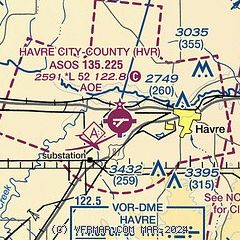
|
| Airport distance calculator |
|---|
|
|
| Sunrise and sunset |
|---|
|
Times for 31-May-2026
| | Local
(UTC-6) | | Zulu
(UTC) |
|---|
| Morning civil twilight | | 04:43 | | 10:43 |
| Sunrise | | 05:23 | | 11:23 |
| Sunset | | 21:10 | | 03:10 |
| Evening civil twilight | | 21:51 | | 03:51 |
|
| Current date and time |
|---|
| Zulu (UTC) | 31-May-2026 22:22:36 |
|---|
| Local (UTC-6) | 31-May-2026 16:22:36 |
|---|
|
| METAR |
|---|
| KHVR | 312153Z AUTO 28018G28KT 8SM -RA FEW010 BKN016 OVC027 09/08 A2993 RMK AO2 PK WND 30032/2107 SLP139 P0007 T00940083
|
|
| TAF |
|---|
| KHVR | 311741Z 3118/0118 29020G30KT P6SM OVC010 PROB30 3118/3122 6SM -RA OVC008 FM312200 28020G30KT 6SM -RA BR OVC010 TEMPO 3122/0102 3SM -RA OVC008 FM010200 27020G30KT 3SM -RA OVC008 FM011200 25015G25KT 6SM -RA BR OVC010
|
|
| NOTAMs |
|---|
NOTAMs are issued by the DoD/FAA and will open in a separate window not controlled by AirNav.
|
|

