FAA INFORMATION EFFECTIVE 14 MAY 2026
Location
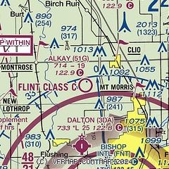
| FAA Identifier: | 51G |
| Lat/Long: | 43-08-36.2484N 083-47-49.1325W
43-08.604140N 083-47.818875W
43.1434023,-83.7969813
(estimated) |
| Elevation: | 714 ft. / 218 m (estimated) |
| Variation: | 06W (1985) |
| From city: | 3 miles SW of CLIO, MI |
| Time zone: | UTC -4 (UTC -5 during Standard Time) |
| Zip code: | 48420 |
Airport Operations
| Airport use: | Open to the public |
| Activation date: | 05/1945 |
| Control tower: | no |
| ARTCC: | CLEVELAND CENTER |
| FSS: | LANSING FLIGHT SERVICE STATION |
| NOTAMs facility: | LAN (NOTAM-D service available) |
| Attendance: | IREG |
| Wind indicator: | yes |
| Segmented circle: | no |
Airport Communications
| CTAF: | 122.9 |
| WX ASOS at FNT (11 nm S): | PHONE 810-202-2914 |
| WX AWOS-3P at RNP (17 nm SW): | 118.025 (989-729-2967) |
| WX AWOS-3P at HYX (18 nm N): | 118.325 (989-752-3408) |
Nearby radio navigation aids
| VOR radial/distance | | VOR name | | Freq | | Var |
|---|
| FNTr354/10.8 | | FLINT VORTAC | | 116.90 | | 06W |
| MBSr155/26.3 | | SAGINAW VOR/DME | | 114.35 | | 03W |
Airport Services
| Parking: | tiedowns |
| Airframe service: | NONE |
| Powerplant service: | NONE |
| Bottled oxygen: | NONE |
| Bulk oxygen: | NONE |
Runway Information
Runway 3/21
| Dimensions: | 1933 x 100 ft. / 589 x 30 m |
| Surface: | turf, in poor condition
ROUGH. |
| Operational restrictions: | IREG, DEFINED BY MOWING. |
| RUNWAY 3 | | RUNWAY 21 |
| Latitude: | 43-08.505000N | | 43-08.775000N |
| Longitude: | 083-47.906667W | | 083-47.676667W |
| Traffic pattern: | left | | left |
| Runway heading: | 038 magnetic, 032 true | | 218 magnetic, 212 true |
| Markings: | none | | none |
| Runway end identifier lights: | no | | no |
| Obstructions: | 61 ft. tree, 600 ft. from runway, 9:1 slope to clear
CTLG OBSTN EXCEEDS A 45 DEG SLP. | | 15 ft. bldg, 10 ft. from runway, 120 ft. left of centerline |
Runway 14/32
| Dimensions: | 1895 x 140 ft. / 578 x 43 m |
| Surface: | turf, in poor condition
ROUGH; AER 32 WET IN SPRING AFT RAIN. |
| Operational restrictions: | IREG, DEFINED BY MOWING. |
| RUNWAY 14 | | RUNWAY 32 |
| Latitude: | 43-08.700000N | | 43-08.461667N |
| Longitude: | 083-47.910000W | | 083-47.635000W |
| Traffic pattern: | left | | left |
| Runway heading: | 146 magnetic, 140 true | | 326 magnetic, 320 true |
| Markings: | none | | none |
| Runway end identifier lights: | no | | no |
| Obstructions: | 85 ft. tree, 711 ft. from runway, 10 ft. left of centerline, 8:1 slope to clear
CTLG OBSTN EXCEEDS A 45 DEG SLP. | | 43 ft. trees, 53 ft. left and right of centerline |
Runway 18/36
| Dimensions: | 1800 x 100 ft. / 549 x 30 m |
| Surface: | turf, in fair condition |
| Runway edge markings: | 3 FT YELLOW CONES. |
| RUNWAY 18 | | RUNWAY 36 |
| Latitude: | 43-08.738333N | | 43-08.442000N |
| Longitude: | 083-47.900500W | | 083-47.893333W |
| Elevation: | 709.0 ft. | | 714.0 ft. |
| Traffic pattern: | left | | left |
| Runway heading: | 185 magnetic, 179 true | | 005 magnetic, 359 true |
| Displaced threshold: | 600 ft. | | 100 ft. |
| Runway end identifier lights: | no | | no |
| Obstructions: | 45 ft. trees, 288 ft. from runway, 100 ft. right of centerline, 6:1 slope to clear | | 66 ft. trees, 100 ft. left of centerline
CTLG OBSTN EXCEEDS A 45 DEG SLP. |
Airport Ownership and Management from official FAA records
| Ownership: | Privately-owned |
| Owner: | DOUGLAS SMITH
5480 W DODGE RD
CLIO, MI 48420-8558
Phone 810-444-7196 |
| Manager: | DOUGLAS SMITH
5480 W DODGE RD
CLIO, MI 48420-8558
Phone 810-444-7196 |
Additional Remarks
| - | DEER & LRG BIRDS ON & INVOF ARPT. |
| - | RWYS 03/21 & 14/32 LCL USE ONLY; NOT STATE LICENSED. |
| - | FOR CD CTC GREAT LAKES APCH AT 269-459-3345, WHEN APCH CLSD CTC CLEVELAND ARTCC AT 440-774-0224/0490. |
| - | CK NOTAMS FOR FLD CONDS DURG WINTER MONTHS - NO SNOW REMOVAL. |
Instrument Procedures
There are no published instrument procedures at 51G.
Some nearby airports with instrument procedures:
KFNT - Bishop International Airport (11 nm S)
KRNP - Owosso Community Airport (17 nm SW)
KHYX - Saginaw County/H W Browne Airport (18 nm N)
9G2 - Price's Airport (20 nm S)
D95 - Dupont/Lapeer Airport (23 nm E)
|
|

Road maps at:
MapQuest
Bing
Google
| Aerial photo |
|---|

|
| Sectional chart |
|---|
|
| Airport distance calculator |
|---|
|
|
| Sunrise and sunset |
|---|
|
Times for 05-Jun-2026
| | Local
(UTC-4) | | Zulu
(UTC) |
|---|
| Morning civil twilight | | 05:23 | | 09:23 |
| Sunrise | | 05:58 | | 09:58 |
| Sunset | | 21:10 | | 01:10 |
| Evening civil twilight | | 21:45 | | 01:45 |
|
| Current date and time |
|---|
| Zulu (UTC) | 05-Jun-2026 21:21:24 |
|---|
| Local (UTC-4) | 05-Jun-2026 17:21:24 |
|---|
|
| METAR |
|---|
KFNT
11nm S | 052053Z 22008KT 10SM FEW047 BKN065 BKN080 21/19 A2990 RMK AO2 RAE18 SLP123 P0006 60017 T02110189 50000
|
KRNP
17nm SW | 052055Z AUTO 21007KT 10SM BKN060 BKN070 BKN120 21/17 A2989 RMK AO2 T02100167
|
KHYX
18nm N | 052055Z AUTO 22012G17KT 10SM -RA OVC013 21/19 A2987 RMK AO2 P0001
|
|
| TAF |
|---|
KFNT
11nm S | 051730Z 0518/0618 23013G24KT 6SM -SHRA OVC045 TEMPO 0521/0601 3SM TSRA OVC030CB FM060100 21008KT 4SM BR OVC025 FM060300 23009KT 6SM BR OVC015 TEMPO 0605/0608 3SM TSRA OVC012CB FM061600 28012G20KT P6SM SCT030 BKN100 PROB30 0616/0618 4SM -SHRA BKN030
|
|
| NOTAMs |
|---|
NOTAMs are issued by the DoD/FAA and will open in a separate window not controlled by AirNav.
|
|

