FAA INFORMATION EFFECTIVE 14 MAY 2026
Location
| FAA Identifier: | D95 |
| Lat/Long: | 43-03-59.3000N 083-16-17.6000W
43-03.988333N 083-16.293333W
43.0664722,-83.2715556
(estimated) |
| Elevation: | 834.6 ft. / 254.4 m (surveyed) |
| Variation: | 07W (2000) |
| From city: | 2 miles NE of LAPEER, MI |
| Time zone: | UTC -4 (UTC -5 during Standard Time) |
| Zip code: | 48446 |
Airport Operations
| Airport use: | Open to the public |
| Activation date: | 07/1944 |
| Control tower: | no |
| ARTCC: | CLEVELAND CENTER |
| FSS: | LANSING FLIGHT SERVICE STATION |
| NOTAMs facility: | D95 (NOTAM-D service available) |
| Attendance: | IREG |
| Wind indicator: | lighted |
| Segmented circle: | yes |
| Lights: | ACTVT REIL RWY 18 & 36; PAPI RWY 18 & 36; MIRL RWY 18/36 - CTAF. |
| Beacon: | white-green (lighted land airport)
Operates sunset to sunrise. |
Airport Communications
| CTAF/UNICOM: | 123.0 |
| WX AWOS-3P: | 134.050 (810-664-5038) |
| GREAT LAKES APPROACH: | 118.8 |
| GREAT LAKES DEPARTURE: | 118.8 |
- APCH/DEP SVC PRVDD BY CLEVELAND ARTCC (ZOB) ON FREQS 126.75/348.75 (FLINT RCAG) WHEN GREAT LAKES APCH CTL CLSD.
- APCH/DEP & CLEARANCE DELIVERY NOT AVBL ON THE GROUND.
Nearby radio navigation aids
| VOR radial/distance | | VOR name | | Freq | | Var |
|---|
| FNTr080/21.7 | | FLINT VORTAC | | 116.90 | | 06W |
Airport Services
| Fuel available: | 100LL JET-A+ |
| Parking: | hangars and tiedowns |
| Airframe service: | NONE |
| Powerplant service: | NONE |
| Bottled oxygen: | NONE |
| Bulk oxygen: | NONE |
Runway Information
Runway 18/36
| Dimensions: | 3800 x 75 ft. / 1158 x 23 m |
| Surface: | asphalt, in fair condition |
| Runway edge lights: | medium intensity |
| RUNWAY 18 | | RUNWAY 36 |
| Latitude: | 43-04.335967N | | 43-03.710983N |
| Longitude: | 083-16.351175W | | 083-16.313795W |
| Elevation: | 834.5 ft. | | 829.3 ft. |
| Traffic pattern: | left | | left |
| Runway heading: | 184 magnetic, 177 true | | 004 magnetic, 357 true |
| Markings: | nonprecision, in good condition | | nonprecision, in good condition |
| Visual slope indicator: | 4-light PAPI on left (4.00 degrees glide path) | | 4-light PAPI on left (4.00 degrees glide path) |
| Runway end identifier lights: | yes | | yes |
| Touchdown point: | yes, no lights | | yes, no lights |
Runway 9/27
| Dimensions: | 1879 x 150 ft. / 573 x 46 m |
| Surface: | turf, in fair condition |
| Runway edge markings: | 3 FT YELLOW CONES. |
| Operational restrictions: | CLSD NOV-APR & WHEN SNOW COVD. |
| RUNWAY 9 | | RUNWAY 27 |
| Latitude: | 43-03.912368N | | 43-03.925633N |
| Longitude: | 083-16.422212W | | 083-16.000713W |
| Elevation: | 829.6 ft. | | 828.0 ft. |
| Traffic pattern: | left | | left |
| Runway heading: | 095 magnetic, 088 true | | 275 magnetic, 268 true |
| Displaced threshold: | 488 ft. | | no |
| Runway end identifier lights: | no | | no |
| Touchdown point: | yes, no lights | | yes, no lights |
| Obstructions: | 14 ft. road, 125 ft. right of centerline
CTLNG OBSTN EXCEEDS A 45 DEG SLP. RWY 09 APCH RATIO 20:1 TO DTHR. | | 13 ft. trees, 125 ft. right of centerline
CTLNG OBSTN EXCEEDS A 45 DEG SLP. |
Airport Ownership and Management from official FAA records
| Ownership: | Publicly-owned |
| Owner: | MAYFIELD TWP
1900 N SAGINAW RD
LAPEER, MI 48446-7785
Phone 810-664-0821 |
| Manager: | JOHN M LEWIS
1232 ROODS LAKE RD
LAPEER, MI 48446-7785
Phone 810-441-4396 |
Additional Remarks
| - | FOR CD CTC GREAT LAKES APCH AT 269-459-3345, WHEN APCH CLSD CTC CLEVELAND ARTCC AT 440-774-0224/0490. |
| - | DEER & LRG BIRDS ON & INVOF ARPT. |
| - | 26 FT MKD PLINE, 750 FT FM RWY END 36, 180 FT LEFT & RIGHT OF EXTDD CNTRLN. |
Instrument Procedures
NOTE: All procedures below are presented as PDF files. If you need a reader for these files, you should download the free Adobe Reader.NOT FOR NAVIGATION. Please procure official charts for flight.
FAA instrument procedures published for use from 14 May 2026 at 0901Z to 11 June 2026 at 0900Z.
IAPs - Instrument Approach Procedures |
|---|
| RNAV (GPS) RWY 18 | |
download (220KB) |
| RNAV (GPS) RWY 36 | |
download (227KB) |
| VOR-A | |
download (186KB) |
| NOTE: Special Alternate Minimums apply | |
download (136KB) |
| NOTE: Special Take-Off Minimums/Departure Procedures apply | |
download (352KB) |
Other nearby airports with instrument procedures:
77G - Marlette Township Airport (17 nm NE)
D98 - Romeo State Airport (21 nm SE)
KFNT - Bishop International Airport (22 nm W)
KCFS - Tuscola Area Airport (25 nm N)
KPTK - Oakland County International Airport (25 nm S)
|
|

Road maps at:
MapQuest
Bing
Google
| Aerial photo |
|---|
WARNING: Photo may not be current or correct
 Photo by Aaron Kendal
Photo taken 08-Apr-2018
looking southwest.
Photo by Aaron Kendal
Photo taken 08-Apr-2018
looking southwest.
Do you have a better or more recent aerial photo of Dupont/Lapeer Airport that you would like to share? If so, please send us your photo.
|
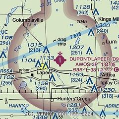
| Sectional chart |
|---|
|
| Airport distance calculator |
|---|
|
|
| Sunrise and sunset |
|---|
|
Times for 26-May-2026
| | Local
(UTC-4) | | Zulu
(UTC) |
|---|
| Morning civil twilight | | 05:27 | | 09:27 |
| Sunrise | | 06:01 | | 10:01 |
| Sunset | | 20:59 | | 00:59 |
| Evening civil twilight | | 21:33 | | 01:33 |
|
| Current date and time |
|---|
| Zulu (UTC) | 26-May-2026 13:39:38 |
|---|
| Local (UTC-4) | 26-May-2026 09:39:38 |
|---|
|
| METAR |
|---|
| KD95 | 261315Z AUTO 21006KT 10SM CLR 22/11 A3011 RMK AO2
|
|
| TAF |
|---|
KFNT
22nm W | 261120Z 2612/2712 20005KT P6SM SCT250 FM261400 24009KT P6SM BKN250 FM270400 VRB04KT P6SM BKN250
|
KPTK
25nm S | 261120Z 2612/2712 20003KT P6SM BKN250 FM261400 22007KT P6SM BKN250 FM270400 VRB04KT P6SM BKN250
|
|
| NOTAMs |
|---|
NOTAMs are issued by the DoD/FAA and will open in a separate window not controlled by AirNav.
|
|

