FAA INFORMATION EFFECTIVE 14 MAY 2026
Location
| FAA Identifier: | GNF |
| Lat/Long: | 33-49-56.8000N 089-47-53.4000W
33-49.946667N 089-47.890000W
33.8324444,-89.7981667
(estimated) |
| Elevation: | 207.9 ft. / 63.4 m (surveyed) |
| Variation: | 01E (1995) |
| From city: | 3 miles N of GRENADA, MS |
| Time zone: | UTC -5 (UTC -6 during Standard Time) |
| Zip code: | 38901 |
Airport Operations
| Airport use: | Open to the public |
| Activation date: | 02/1944 |
| Control tower: | no |
| ARTCC: | MEMPHIS CENTER |
| FSS: | GREENWOOD FLIGHT SERVICE STATION |
| NOTAMs facility: | GWO (NOTAM-D service available) |
| Attendance: | SUN 1300-1700, ALL MON-SAT ON CALL
662-230-3646.
FOR FUEL CALL 662-230-3646. |
| Wind indicator: | lighted |
| Segmented circle: | yes |
| Lights: | SS-SR |
| Beacon: | white-green (lighted land airport)
Operates sunset to sunrise. |
Airport Communications
| CTAF/UNICOM: | 122.8 |
| WX AWOS-3PT: | 118.025 (662-227-3407) |
- APCH/DEP SVC PRVDD BY MEMPHIS ARTCC (ZME) ON FREQS 128.5/279.55 (TUPELO RCAG).
Nearby radio navigation aids
| VOR radial/distance | | VOR name | | Freq | | Var |
|---|
| SQSr044/32.6 | | SIDON VORTAC | | 114.70 | | 03E |
Airport Services
| Fuel available: | 100LL JET-A |
| Parking: | tiedowns |
| Bottled oxygen: | NONE |
| Bulk oxygen: | NONE |
Runway Information
Runway 13/31
| Dimensions: | 7000 x 150 ft. / 2134 x 46 m |
| Surface: | asphalt, in fair condition |
| Weight bearing capacity: | | Single wheel: | 60.0 | | Double wheel: | 200.0 | | Double tandem: | 300.0 |
|
| Runway edge lights: | medium intensity |
| Operational restrictions: | 200 FT BY 150 FT ASPH OVRN AVBL. |
| RUNWAY 13 | | RUNWAY 31 |
| Latitude: | 33-50.485755N | | 33-49.716197N |
| Longitude: | 089-48.511778W | | 089-47.480995W |
| Elevation: | 207.6 ft. | | 197.8 ft. |
| Traffic pattern: | left | | left |
| Runway heading: | 131 magnetic, 132 true | | 311 magnetic, 312 true |
| Markings: | precision, in fair condition | | precision, in fair condition |
| Visual slope indicator: | 4-box VASI on left (3.00 degrees glide path) | | 4-box VASI on left (3.00 degrees glide path) |
| Approach lights: | MALSR: 1,400 foot medium intensity approach lighting system with runway alignment indicator lights | | |
| Touchdown point: | yes, no lights | | yes, no lights |
| Instrument approach: | ILS/DME | | |
| Obstructions: | none | | 76 ft. trees, 2350 ft. from runway, 27:1 slope to clear |
Runway 4/22
| Dimensions: | 4998 x 99 ft. / 1523 x 30 m |
| Surface: | asphalt, in poor condition
ASPH CRACKED & HAS DEPRESSIONS. |
| Weight bearing capacity: | | Single wheel: | 60.0 | | Double wheel: | 200.0 | | Double tandem: | 300.0 |
|
| Runway edge markings: | FADED. |
| RUNWAY 4 | | RUNWAY 22 |
| Latitude: | 33-49.476225N | | 33-49.985307N |
| Longitude: | 089-48.130575W | | 089-47.354032W |
| Elevation: | 192.9 ft. | | 201.3 ft. |
| Traffic pattern: | left | | left |
| Runway heading: | 051 magnetic, 052 true | | 231 magnetic, 232 true |
| Displaced threshold: | no | | 272 ft. |
| Markings: | basic, in poor condition | | basic, in poor condition |
| Touchdown point: | yes, no lights | | yes, no lights |
| Obstructions: | 59 ft. trees, 1350 ft. from runway, 19:1 slope to clear | | 15 ft. road, 200 ft. from runway, 225 ft. right of centerline
PAVED RD 200 FT FM RWY END 225 FT R & 167 FT L. |
Airport Ownership and Management from official FAA records
| Ownership: | Publicly-owned |
| Owner: | CITY OF GRENADA
PO BOX 310
GRENADA, MS 38902
Phone 662-226-8820 |
| Manager: | RANDY ADAMS
PO BOX 310
GRENADA, MS 38902
Phone 662-227-8402 |
Additional Remarks
| - | EXTSV AGRICULTURE OPS INVOF ARPT SR-SS MAR-OCT. |
| - | BIRDS & DEER INVOF ARPT. |
| - | AEROBATIC ACFT DALGT HRS; 7000 FT & BLW WITHIN 3 NM OF ARPT. |
| - | FOR CD CTC MEMPHIS ARTCC AT 901-368-8453/8449. |
| - | ILS DCMSND. |
Instrument Procedures
NOTE: All procedures below are presented as PDF files. If you need a reader for these files, you should download the free Adobe Reader.NOT FOR NAVIGATION. Please procure official charts for flight.
FAA instrument procedures published for use from 14 May 2026 at 0901Z to 11 June 2026 at 0900Z.
IAPs - Instrument Approach Procedures |
|---|
| RNAV (GPS) RWY 04 | |
download (198KB) |
| RNAV (GPS) RWY 13 | |
download (256KB) |
| RNAV (GPS) RWY 22 | |
download (196KB) |
| RNAV (GPS) RWY 31 | |
download (242KB) |
| NOTE: Special Alternate Minimums apply | |
download (165KB) |
| NOTE: Special Take-Off Minimums/Departure Procedures apply | |
download (116KB) |
Other nearby airports with instrument procedures:
5A6 - Winona-Montgomery County Airport (22 nm S)
KGWO - Greenwood-Leflore Airport (25 nm SW)
KPMU - Panola County Airport (32 nm N)
KMMS - Selfs Airport (34 nm NW)
KUOX - University-Oxford Airport (36 nm N)
|
|

Road maps at:
MapQuest
Bing
Google
| Aerial photo |
|---|
WARNING: Photo may not be current or correct
 Photo by Dan Campbell
Photo taken 07-Oct-2007
Photo by Dan Campbell
Photo taken 07-Oct-2007
Do you have a better or more recent aerial photo of Grenada Municipal Airport that you would like to share? If so, please send us your photo.
|
| Sectional chart |
|---|
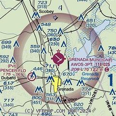
|
| Airport distance calculator |
|---|
|
|
| Sunrise and sunset |
|---|
|
Times for 20-May-2026
| | Local
(UTC-5) | | Zulu
(UTC) |
|---|
| Morning civil twilight | | 05:28 | | 10:28 |
| Sunrise | | 05:56 | | 10:56 |
| Sunset | | 19:56 | | 00:56 |
| Evening civil twilight | | 20:24 | | 01:24 |
|
| Current date and time |
|---|
| Zulu (UTC) | 20-May-2026 07:56:40 |
|---|
| Local (UTC-5) | 20-May-2026 02:56:40 |
|---|
|
| TAF |
|---|
KGWO
25nm SW | 200540Z 2006/2106 05005KT P6SM -SHRA SCT050 BKN110 FM200700 17003KT P6SM VCSH FEW015 SCT070 FM201000 00000KT 5SM BR VCSH BKN012 FM201600 00000KT P6SM -SHRA SCT015 PROB30 2019/2023 6SM -TSRA OVC035CB FM202300 36005KT P6SM OVC100
|
|
| NOTAMs |
|---|
NOTAMs are issued by the DoD/FAA and will open in a separate window not controlled by AirNav.
|
|

