FAA INFORMATION EFFECTIVE 14 MAY 2026
Location
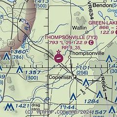
| FAA Identifier: | 7Y2 |
| Lat/Long: | 44-31-04.0606N 085-58-14.0442W
44-31.067677N 085-58.234070W
44.5177946,-85.9705678
(estimated) |
| Elevation: | 793 ft. / 241.7 m (surveyed) |
| Variation: | 04W (1985) |
| From city: | 2 miles W of THOMPSONVILLE, MI |
| Time zone: | UTC -4 (UTC -5 during Standard Time) |
| Zip code: | 49683 |
Airport Operations
| Airport use: | Open to the public |
| Activation date: | 08/1948 |
| Control tower: | no |
| ARTCC: | MINNEAPOLIS CENTER |
| FSS: | LANSING FLIGHT SERVICE STATION |
| NOTAMs facility: | LAN (NOTAM-D service available) |
| Attendance: | UNATNDD |
| Wind indicator: | lighted |
| Segmented circle: | yes |
| Lights: | ACTVT PAPI RWY 27; LIRL RWY 09/27 - 5 CLICKS CTAF (3 CLICKS OFF). |
| Beacon: | white-green (lighted land airport)
ARPT ROTG BCN ON SKI HILL, 450 FT ABV ARPT ELEV, 1.0 MI NW. Operates sunset to sunrise. |
Airport Communications
| CTAF: | 122.9 |
| WX AWOS-3P at FKS (12 nm NW): | 118.325 (231-352-7573) |
| WX AWOS-3PT at MBL (19 nm SW): | 118.825 (231-723-6073) |
Nearby radio navigation aids
| VOR radial/distance | | VOR name | | Freq | | Var |
|---|
| TVCr245/20.1 | | TRAVERSE CITY VOR/DME | | 114.60 | | 02W |
Airport Services
Runway Information
Runway 9/27
| Dimensions: | 2900 x 75 ft. / 884 x 23 m |
| Surface: | asphalt, in good condition |
| Weight bearing capacity: | |
| Runway edge lights: | low intensity |
| RUNWAY 9 | | RUNWAY 27 |
| Latitude: | 44-31.098333N | | 44-31.133333N |
| Longitude: | 085-58.693333W | | 085-58.027833W |
| Elevation: | 793.0 ft. | | 793.0 ft. |
| Traffic pattern: | right | | left |
| Displaced threshold: | 60 ft. | | no |
| Markings: | basic, in fair condition | | basic, in fair condition |
| Visual slope indicator: | | | 2-light PAPI on left (4.00 degrees glide path) |
| Obstructions: | 14 ft. road, 240 ft. from runway, 2:1 slope to clear
+4 FT FENCE, 185 FT DIST, L/R. | | none |
Runway 17/35
| Dimensions: | 2475 x 150 ft. / 754 x 46 m |
| Surface: | turf, in fair condition |
| Runway edge markings: | RWY & DTHR MKD WITH 3 FT YELLOW CONES. |
| Operational restrictions: | CLSD TO TSNT ACFT CTC AMGR FOR DTLS; CLSD NOV-MAR & WHEN SNOW COVD. NO SNOW REMOVAL. |
| RUNWAY 17 | | RUNWAY 35 |
| Latitude: | 44-31.211667N | | 44-30.810833N |
| Longitude: | 085-58.136667W | | 085-58.035000W |
| Elevation: | 793.0 ft. | | 793.0 ft. |
| Traffic pattern: | left | | right |
| Displaced threshold: | 1212 ft. | | 1085 ft. |
| Obstructions: | 69 ft. trees, 43 ft. from runway, 110 ft. left of centerline
CTLG OBSTN EXCEEDS A 45 DEG SLP. APCH SLP 18:1 TO DTHR OVR 76 FT TREES, 1440 FT DIST. | | 63 ft. trees, 18 ft. from runway
CTLG OBSTN EXCEEDS A 45 DEG SLP. APCH SLP 17:1 TO DTHR OVR 63 FT TREES, 1103 FT DIST. |
Airport Ownership and Management from official FAA records
| Ownership: | Publicly-owned |
| Owner: | VILLAGE OF THOMPSONVILLE
14714 LINCOLN AVE
THOMPSONVILLE, MI 49683-9109
Phone 231-378-2575 |
| Manager: | DAVE TERHAAR
13998 HONOR HWY
BEULAH, MI 49617-9762
Phone 616-403-3469
CELL. RES 231-378-2435. |
Additional Remarks
| - | +450 FT UNLGTD SKI HILL, 0.5 NM WEST OF ARPT. |
| - | ADMIN BLDG & RESTROOM ACES: 5-3-2-1. |
| - | FOR CD CTC MINNEAPOLIS ARTCC AT 651-463-5588. |
Instrument Procedures
There are no published instrument procedures at 7Y2.
Some nearby airports with instrument procedures:
KFKS - Frankfort Dow Memorial Field (12 nm NW)
KMBL - Manistee County/Blacker Airport (19 nm SW)
KTVC - Cherry Capital Airport (21 nm NE)
KCAD - Wexford County Airport (28 nm SE)
KLDM - Mason County Airport (38 nm SW)
|
|

Road maps at:
MapQuest
Bing
Google
| Aerial photo |
|---|
WARNING: Photo may not be current or correct
 Taken in July 2007
looking north
Taken in July 2007
looking north
Do you have a better or more recent aerial photo of Thompsonville Airport that you would like to share? If so, please send us your photo.
|
| Sectional chart |
|---|
|
| Airport distance calculator |
|---|
|
|
| Sunrise and sunset |
|---|
|
Times for 20-May-2026
| | Local
(UTC-4) | | Zulu
(UTC) |
|---|
| Morning civil twilight | | 05:38 | | 09:38 |
| Sunrise | | 06:12 | | 10:12 |
| Sunset | | 21:09 | | 01:09 |
| Evening civil twilight | | 21:43 | | 01:43 |
|
| Current date and time |
|---|
| Zulu (UTC) | 20-May-2026 13:17:21 |
|---|
| Local (UTC-4) | 20-May-2026 09:17:21 |
|---|
|
| METAR |
|---|
KFKS
12nm NW | 201256Z AUTO 36008G14KT 10SM CLR 08/04 A3026 RMK AO2
|
KMBL
19nm SW | 201256Z AUTO 35009KT 10SM CLR 11/05 A3025 RMK AO2 SLP247 T01060050 $
|
KTVC
22nm NE | 201253Z 02009KT 10SM SCT015 BKN023 BKN250 07/02 A3024 RMK AO2 SLP245 T00670022
|
|
| TAF |
|---|
KMBL
19nm SW | 201120Z 2012/2112 33006KT P6SM FEW250 FM201400 35009G17KT P6SM FEW250 FM210300 VRB03KT P6SM FEW250
|
KTVC
22nm NE | 201148Z 2012/2112 36005KT P6SM BKN025 BKN250 FM201400 35009G20KT P6SM FEW250 FM210100 VRB03KT P6SM FEW250
|
|
| NOTAMs |
|---|
NOTAMs are issued by the DoD/FAA and will open in a separate window not controlled by AirNav.
|
|

