FAA INFORMATION EFFECTIVE 14 MAY 2026
Location
| FAA Identifier: | 88NV |
| Lat/Long: | 40-45-42.6196N 119-12-38.6618W
40-45.710327N 119-12.644363W
40.7618388,-119.2107394
(estimated) |
| Elevation: | 3907.7 ft. / 1191.1 m (surveyed) |
| Variation: | 14E () |
| From city: | 9 miles NE of GERLACH, NV |
| Time zone: | UTC -7 (UTC -8 during Standard Time) |
| Zip code: | 89419 |
Airport Operations
| Airport use: | Private use. Permission required prior to landing |
| Activation date: | 07/2009 |
| Control tower: | no |
| ARTCC: | OAKLAND CENTER |
| FSS: | RENO FLIGHT SERVICE STATION |
| Attendance: | UNATNDD |
| Wind indicator: | yes |
| Segmented circle: | no |
Airport Services
Runway Information
Runway 5R/23L
| Dimensions: | 6000 x 75 ft. / 1829 x 23 m |
| Surface: | dirt, in fair condition |
| Runway edge lights: | non-standard |
| Runway edge markings: | UNLGTD CONES. |
| Operational restrictions: | RWY 23L CALM WIND RWY |
| RUNWAY 5R | | RUNWAY 23L |
| Latitude: | 40-45.663333N | | 40-46.068500N |
| Longitude: | 119-12.229667W | | 119-11.044500W |
| Elevation: | 3907.5 ft. | | 3907.7 ft. |
| Traffic pattern: | right | | left |
| Runway heading: | 052 magnetic, 066 true | | 232 magnetic, 246 true |
| Markings: | NSTD, in fair condition | | NSTD, in fair condition |
| Touchdown point: | yes, no lights | | yes, no lights |
Runway 5L/23R
| Dimensions: | 5500 x 75 ft. / 1676 x 23 m |
| Surface: | dirt, in fair condition |
| Runway edge lights: | non-standard |
| Runway edge markings: | UNLGTD CONES. |
| RUNWAY 5L | | RUNWAY 23R |
| Latitude: | 40-45.312333N | | 40-45.683167N |
| Longitude: | 119-13.800167W | | 119-12.713167W |
| Elevation: | 3906.1 ft. | | 3906.9 ft. |
| Traffic pattern: | left | | right |
| Runway heading: | 052 magnetic, 066 true | | 232 magnetic, 246 true |
| Markings: | NSTD, in fair condition | | NSTD, in fair condition |
| Touchdown point: | yes, no lights | | yes, no lights |
Runway 7/25
| Dimensions: | 4000 x 40 ft. / 1219 x 12 m |
| Surface: | dirt, in fair condition |
| Runway edge lights: | non-standard |
| RUNWAY 7 | | RUNWAY 25 |
| Latitude: | 40-45.738050N | | 40-45.800417N |
| Longitude: | 119-13.744833W | | 119-12.881900W |
| Elevation: | 3905.8 ft. | | 3906.5 ft. |
| Traffic pattern: | left | | left |
| Markings: | NSTD, in fair condition | | NSTD, in fair condition |
| Touchdown point: | yes, no lights | | yes, no lights |
Airport Ownership and Management from official FAA records
| Ownership: | Privately-owned |
| Owner: | US BUREAU OF LAND MANAGEMENT
PO BOX 319
GERLACH, NV 89412
Phone 775-557-2200
LEASED BY BLACK ROCK CITY LLC - 651-387-9044 |
| Manager: | LISA KIPFER
BURNINGMAN PROJECT, 660 ALABAMA STREET, 4TH FLOOR
SAN FRANCISCO, CA 94110
Phone 775-557-6027 |
Additional Remarks
| A30A-23R | PREFERRED DEP RWY. |
| - | PREREGISTRATION & PPR FOR USE. |
| - | UNICOM WLAV CURRENT CONDS. |
| - | SKYDIVING & TOUR OPS ACT ON & INVOF ARPT. |
| - | FOR CD CTC OAKLAND ARTCC AT 510-745-3380. |
Instrument Procedures
There are no published instrument procedures at 88NV.
Some nearby airports with instrument procedures:
KLOL - Derby Field Airport (51 nm SE)
KAHC - Amedee Army Airfield (52 nm SW)
KWMC - Winnemucca Municipal Airport (64 nm E)
KSVE - Susanville Municipal Airport (66 nm W)
KRTS - Reno/Stead Airport (72 nm SW)
|
|
| Aerial photo |
|---|
WARNING: Photo may not be current or correct
 Photo taken 01-Sep-2019
looking northeast.
Photo taken 01-Sep-2019
looking northeast.
Do you have a better or more recent aerial photo of Black Rock City Airport that you would like to share? If so, please send us your photo.
|
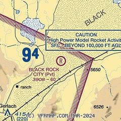
| Sectional chart |
|---|
|
| Airport distance calculator |
|---|
|
|
| Sunrise and sunset |
|---|
|
Times for 01-Jun-2026
| | Local
(UTC-7) | | Zulu
(UTC) |
|---|
| Morning civil twilight | | 04:56 | | 11:56 |
| Sunrise | | 05:29 | | 12:29 |
| Sunset | | 20:21 | | 03:21 |
| Evening civil twilight | | 20:53 | | 03:53 |
|
| Current date and time |
|---|
| Zulu (UTC) | 01-Jun-2026 21:44:27 |
|---|
| Local (UTC-7) | 01-Jun-2026 14:44:27 |
|---|
|
| NOTAMs |
|---|
NOTAMs are issued by the DoD/FAA and will open in a separate window not controlled by AirNav.
|
|

