FAA INFORMATION EFFECTIVE 14 MAY 2026
Location
| FAA Identifier: | 8V2 |
| Lat/Long: | 42-33-45.7160N 099-02-19.7170W
42-33.761933N 099-02.328617W
42.5626989,-99.0388103
(estimated) |
| Elevation: | 2131 ft. / 650 m (estimated) |
| Variation: | 06E (2010) |
| From city: | 3 miles NW of ATKINSON, NE |
| Time zone: | UTC -5 (UTC -6 during Standard Time) |
| Zip code: | 68713 |
Airport Operations
| Airport use: | Open to the public |
| Activation date: | 01/1949 |
| Control tower: | no |
| ARTCC: | MINNEAPOLIS CENTER |
| FSS: | COLUMBUS FLIGHT SERVICE STATION |
| NOTAMs facility: | OLU (NOTAM-D service available) |
| Attendance: | UNATNDD |
| Wind indicator: | lighted |
| Segmented circle: | yes |
| Lights: | ACTVT REIL RWY 11 & 29; PAPI RWY 11/29; MIRL RWY 11/29 PRESET MED INTST SS-SR, TO INCR INTST & ACTVT- CTAF. |
| Beacon: | white-green (lighted land airport)
Operates sunset to sunrise. |
Airport Communications
| CTAF: | 122.9 |
| WX AWOS-3 at ONL (17 nm E): | 121.125 (402-336-4834) |
- APCH/DEP SVC PRVDD BY MINNEAPOLIS ARTCC ON FREQS 128.0/257.95 (O'NEILL RCAG).
Nearby radio navigation aids
| VOR radial/distance | | VOR name | | Freq | | Var |
|---|
| ONLr280/16.5 | | O'NEILL VORTAC | | 113.90 | | 10E |
Airport Services
| Fuel available: | 100LL
100LL:FOR FUEL CALL (402) 925-5527 OR (402) 340-0388. |
| Parking: | tiedowns |
| Airframe service: | NONE |
| Powerplant service: | NONE |
| Bottled oxygen: | NONE |
| Bulk oxygen: | NONE |
Runway Information
Runway 11/29
| Dimensions: | 3900 x 60 ft. / 1189 x 18 m |
| Surface: | concrete, in good condition |
| Weight bearing capacity: | |
| Runway edge lights: | medium intensity |
| RUNWAY 11 | | RUNWAY 29 |
| Latitude: | 42-33.921635N | | 42-33.603865N |
| Longitude: | 099-02.814045W | | 099-02.059318W |
| Elevation: | 2131.3 ft. | | 2126.1 ft. |
| Traffic pattern: | left | | left |
| Runway heading: | 114 magnetic, 120 true | | 294 magnetic, 300 true |
| Markings: | nonprecision, in good condition | | nonprecision, in good condition |
| Visual slope indicator: | 2-light PAPI on left (3.00 degrees glide path) | | 2-light PAPI on left (3.00 degrees glide path) |
| Runway end identifier lights: | yes | | yes |
| Touchdown point: | yes, no lights | | yes, no lights |
Runway 5/23
| Dimensions: | 2970 x 100 ft. / 905 x 30 m
NARROWED TO 100', CENTERLINE STAYED THE SAME. |
| Surface: | turf, in fair condition |
| Runway edge markings: | NSTD MKGS RY 05/23 MARKED WITH YELLOW CONES. |
| RUNWAY 5 | | RUNWAY 23 |
| Latitude: | 42-33.637333N | | 42-33.884333N |
| Longitude: | 099-02.472167W | | 099-01.901267W |
| Elevation: | 2121.8 ft. | | 2127.4 ft. |
| Traffic pattern: | left | | left |
| Runway heading: | 054 magnetic, 060 true | | 234 magnetic, 240 true |
| Markings: | NSTD | | NSTD |
| Touchdown point: | yes, no lights | | yes, no lights |
Airport Ownership and Management from official FAA records
| Ownership: | Publicly-owned |
| Owner: | STUART ATKINSON AIRPORT AUTH
P.O. BOX 265
STUART, NE 68780-0265
Phone 402-340-0388 |
| Manager: | JACK FLANNERY
PO BOX 83
ATKINSON, NE 68713-0083
Phone 402-340-0388 |
Additional Remarks
| - | FOR CD CTC MINNEAPOLIS ARTCC AT 651-463-5588. |
Instrument Procedures
NOTE: All procedures below are presented as PDF files. If you need a reader for these files, you should download the free Adobe Reader.NOT FOR NAVIGATION. Please procure official charts for flight.
FAA instrument procedures published for use from 14 May 2026 at 0901Z to 11 June 2026 at 0900Z.
IAPs - Instrument Approach Procedures |
|---|
| RNAV (GPS) RWY 11 | |
download (215KB) |
| RNAV (GPS) RWY 29 | |
download (208KB) |
| NOTE: Special Take-Off Minimums/Departure Procedures apply | |
download (147KB) |
Other nearby airports with instrument procedures:
KONL - The O'Neill Municipal Airport-John L Baker Field (17 nm E)
KRBE - Rock County Airport (23 nm W)
KANW - Ainsworth Regional Airport (42 nm W)
9D1 - Gregory Municipal Airport/Flynn Field (43 nm N)
KAGZ - Wagner Municipal Airport (44 nm NE)
|
|

Road maps at:
MapQuest
Bing
Google
| Aerial photo |
|---|
WARNING: Photo may not be current or correct
 Photo taken 28-May-2005
Do you have a better or more recent aerial photo of Stuart-Atkinson Municipal Airport that you would like to share? If so, please send us your photo.
|
| Sectional chart |
|---|
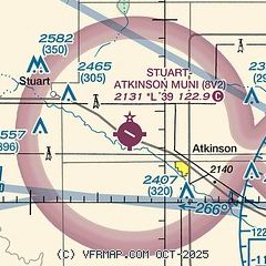
|
| Airport distance calculator |
|---|
|
|
| Sunrise and sunset |
|---|
|
Times for 03-Jun-2026
| | Local
(UTC-5) | | Zulu
(UTC) |
|---|
| Morning civil twilight | | 05:27 | | 10:27 |
| Sunrise | | 06:01 | | 11:01 |
| Sunset | | 21:07 | | 02:07 |
| Evening civil twilight | | 21:42 | | 02:42 |
|
| Current date and time |
|---|
| Zulu (UTC) | 03-Jun-2026 16:27:22 |
|---|
| Local (UTC-5) | 03-Jun-2026 11:27:22 |
|---|
|
| METAR |
|---|
KONL
17nm E | 031615Z AUTO 16011G15KT 10SM BKN055 OVC075 19/18 A3015 RMK AO2 T01940181
|
|
| NOTAMs |
|---|
NOTAMs are issued by the DoD/FAA and will open in a separate window not controlled by AirNav.
|
|

