FAA INFORMATION EFFECTIVE 27 NOVEMBER 2025
Location
| FAA Identifier: | AK28 |
| Lat/Long: | 64-48-50.5000N 147-55-06.8000W
64-48.841667N 147-55.113333W
64.8140278,-147.9185556
(estimated) |
| Elevation: | 427 ft. / 130 m (estimated) |
| Variation: | 27E (1990) |
| From city: | 5 miles SW of FAIRBANKS, AK |
| Time zone: | UTC -9 (UTC -8 during Daylight Saving Time) |
| Zip code: | 99709 |
Airport Operations
| Airport use: | Private use. Permission required prior to landing |
| Activation date: | 12/1991 |
| Control tower: | no |
| ARTCC: | ANCHORAGE CENTER |
| FSS: | FAIRBANKS FLIGHT SERVICE STATION [907-474-0788] |
| Attendance: | UNATTND |
| Wind indicator: | yes |
| Segmented circle: | no |
Airport Communications
| CTAF: | 118.3 |
| WX ASOS at FAI (1.6 nm E): | 124.4 (907-621-7609) |
Nearby radio navigation aids
| VOR radial/distance | | VOR name | | Freq | | Var |
|---|
| FAIr050/2.5 | | FAIRBANKS VORTAC | | 108.60 | | 21E |
| ENNr045/32.5 | | NENANA VORTAC | | 115.80 | | 21E |
| NDB name | | Hdg/Dist | | Freq | | Var | | ID |
|---|
| CHENA | | 245/10.9 | | 257 | | 17E | | CUN | -.-. ..- -. |
| ICE POOL | | 049/33.8 | | 525 | | 13E | | ICW | .. -.-. .-- |
Airport Services
| Fuel available: | 100LL
100LL:24 HR. CREDIT CARD PUMP MIDFIELD ON RUNWAY |
Runway Information
Runway 18/36
| Dimensions: | 4700 x 60 ft. / 1433 x 18 m |
| Surface: | gravel, in good condition |
| RUNWAY 18 | | RUNWAY 36 |
| Traffic pattern: | right | | left |
Runway 18W/36W
| Dimensions: | 4000 x 200 ft. / 1219 x 61 m |
| Surface: | water |
| RUNWAY 18W | | RUNWAY 36W |
| Traffic pattern: | right | | left |
Airport Ownership and Management from official FAA records
| Ownership: | Privately-owned |
| Owner: | CHENA MARINA FLOATPOND & RWY ASSOC
P O BOX 83658
FAIRBANKS, AK 99708
Phone 907-479-2141 |
| Manager: | DONALD D KIRK
P.O. BOX 80702
FAIRBANKS, AK 99708
Phone 907-479-2141 |
Additional Remarks
| - | TRANSIENTS NEED TO CTC ONE OF THE NUMEROUS FBO'S OR PROPERTY OWNERS FOR ARRANGEMENTS BEFORE PARKING. |
| - | FLOATPOND FOR USE BY MEMBERS ONLY. FLOAT POND IS UNATTENDED, ALL LANDINGS AT YOUR OWN RISK. |
| - | NUMEROUS AIR TAXI OPERATIONS AND AT TIMES HEAVY TFC ON FLOATPOND. |
| - | NO DESIGNATED TRANSIENT TIEDOWN AREA, ALL PROPERTY BORDERING FLOATPOND IS PRIVATELY OWNED. TRANSIENTS NEED TO CTC ONE OF THE NUMEROUS FBO'S OR PROPERTY OWNERS FOR ARRANGEMENTS BEFORE TIEDOWN/MOORING. |
| - | SUAIS - 125.3/126.3(1-800-758-8723). |
| - | USE AT OWN RISK. CHENA MARINA IS IN FAI CLASS D AIRSPACE, ALL ARRIVING/DEPARTING ACFT MUST CTC FAI TOWER (118 .3) PRIOR TO OPERATING IN THEIR AIRSPACE. |
| - | TFC PATTERN IS ON THE WEST SIDE OF RWYS, WITH CHENA RIDGE BEING THE WESTSIDE BOUNDARY. TPA IS 1000 FT MSL, AND IN NO CASE TO BE ABOVE 1200 FT MSL, TO ALLOW FOR SEPARATION WITH OTHER FAI TFC. |
| - | RWY CLOSELY BORDERED BY TREES, ACFT, AND FLOATPOND. OCCASIONAL VEHICLES, PEOPLE, AND DOGS ON RWY. |
| - | AIR TAXI OPERATIONS AND AT TIMES HEAVY TFC ON FIELD. BE AWARE ALL TFC MAY NOT BE IN SAME DIRECTION AS FAI. |
| - | HARD PACKED SNOW MAINTAINED ON RWY DURING WINTER MONTHS. WHEELED ACFT ADVISED TO CALL A LOCAL, ON SITE FBO, FOR CONDITIONS. |
| - | FLIGHT TRAINING WITH MULTIPLE TKOFS AND LANDINGS NOT ALLOWED. NO STUDENT PILOT SOLO FLIGHTS ALLOWED. |
| - | PLEASE CONSIDER OTHER ACFT WHEN DOING RUN-UPS, AS SUMMER MONTHS VERY DUSTY. NO DESIGNATED TRANSIENT PARKING AREA, ALL PROPERTY BORDERING RUNWAY IS PRIVATELY OWNED. |
Instrument Procedures
There are no published instrument procedures at AK28.
Some nearby airports with instrument procedures:
PAFA - Fairbanks International Airport (2 nm E)
PAFB - Ladd Army Airfield (8 nm E)
PAEI - Eielson Air Force Base (23 nm SE)
PANN - Nenana Municipal Airport (34 nm SW)
PAHV - Healy River Airport (63 nm SW)
|
|

Road maps at:
MapQuest
Bing
Google
| Aerial photo |
|---|
WARNING: Photo may not be current or correct
 Photo by Paul Reinders
Photo taken 02-Jun-2007
Photo by Paul Reinders
Photo taken 02-Jun-2007
Do you have a better or more recent aerial photo of Chena Marina Airport that you would like to share? If so, please send us your photo.
|
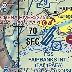
| Sectional chart |
|---|
|
| Airport distance calculator |
|---|
|
|
| Sunrise and sunset |
|---|
|
Times for 13-Dec-2025
| | Local
(UTC-9) | | Zulu
(UTC) |
|---|
| Morning civil twilight | | 09:27 | | 18:27 |
| Sunrise | | 10:50 | | 19:50 |
| Sunset | | 14:42 | | 23:42 |
| Evening civil twilight | | 16:05 | | 01:05 |
|
| Current date and time |
|---|
| Zulu (UTC) | 13-Dec-2025 16:39:45 |
|---|
| Local (UTC-9) | 13-Dec-2025 07:39:45 |
|---|
|
| METAR |
|---|
| PAFA | 131600Z 00000KT 10SM FEW003 M27/M28 A3039 RMK AO2 T12671278 VISNO NE $
|
PAFB
8nm E | 131555Z AUTO 00000KT 10SM CLR M27/M30 A3038 RMK AO2 SLP315 T12671299
|
|
| TAF |
|---|
| PAFA | 131138Z 1312/1418 25009KT P6SM FEW030 SCT100 FM132100 00000KT P6SM FEW010 FEW100 FM140900 00000KT 5SM BR SCT003 FM141200 00000KT P6SM SKC
|
PAFB
8nm E | 130040Z 1300/1405 05006KT 3200 -SN BR SCT006 BKN013 OVC025 650138 540204 QNH3019INS TEMPO 1223/1302 27010G15KT 1600 SN BR OVC006 BECMG 1302/1303 27012G18KT 4800 -SN BR SCT006 BKN022 OVC030 650228 510102 540303 QNH3015INS BECMG 1304/1305 27010G20KT 9999 NSW SCT015 OVC025 620258 520056 QNH3018INS BECMG 1309/1310 27010KT 9999 OVC035 620357 510056 QNH3029INS TXM17/1223Z TNM30/1318Z LAST NO AMDS AFT 1301 NEXT 1515
|
|
| NOTAMs |
|---|
NOTAMs are issued by the DoD/FAA and will open in a separate window not controlled by AirNav.
|
|

