FAA INFORMATION EFFECTIVE 19 FEBRUARY 2026
Location
| FAA Identifier: | AMG |
| Lat/Long: | 31-32-09.8080N 082-30-23.5920W
31-32.163467N 082-30.393200W
31.5360578,-82.5065533
(estimated) |
| Elevation: | 199.8 ft. / 60.9 m (surveyed) |
| Variation: | 06W (2020) |
| From city: | 3 miles W of ALMA, GA |
| Time zone: | UTC -5 (UTC -4 during Daylight Saving Time) |
| Zip code: | 31510 |
Airport Operations
| Airport use: | Open to the public |
| Activation date: | 05/1941 |
| Control tower: | no |
| ARTCC: | JACKSONVILLE CENTER |
| FSS: | MACON FLIGHT SERVICE STATION |
| NOTAMs facility: | AMG (NOTAM-D service available) |
| Attendance: | UNATNDD |
| Wind indicator: | lighted |
| Segmented circle: | yes |
| Lights: | ACTVT REIL RWY 16 & 34; PAPI RWY 16 & 34; MIRL RWY 16/34 - CTAF. |
| Beacon: | white-green (lighted land airport)
Operates sunset to sunrise. |
Airport Communications
| CTAF/UNICOM: | 122.7 |
| WX ASOS: | 118.325 (912-632-8738) |
| WX AWOS-3PT at BHC (12 nm NE): | 118.2 (912-705-5865) |
| WX AWOS-3 at AYS (18 nm S): | 118.575 (912-287-4466) |
| WX AWOS-3 at DQH (18 nm W): | 119.075 (912-383-7258) |
- APCH/DEP SVC PRVDD BY JACKSONVILLE ARTCC ON FREQS 127.575/269.025 (ALMA RCAG).
Nearby radio navigation aids
| VOR radial/distance | | VOR name | | Freq | | Var |
|---|
| AYSr009/16.2 | | WAYCROSS VORTAC | | 112.40 | | 00E |
| NDB name | | Hdg/Dist | | Freq | | Var | | ID |
|---|
| WIKET | | 341/13.8 | | 219 | | 05W | | AY | .- -.-- |
Airport Services
| Fuel available: | 100LL JET-A+ |
| Parking: | tiedowns |
| Airframe service: | MINOR |
| Powerplant service: | MINOR |
| Bottled oxygen: | NONE |
| Bulk oxygen: | NONE |
Runway Information
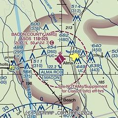
Runway 16/34
| Dimensions: | 5000 x 100 ft. / 1524 x 30 m |
| Surface: | asphalt, in excellent condition |
| Weight bearing capacity: | |
| Runway edge lights: | medium intensity |
| RUNWAY 16 | | RUNWAY 34 |
| Latitude: | 31-32.523705N | | 31-31.803237N |
| Longitude: | 082-30.627377W | | 082-30.159045W |
| Elevation: | 199.8 ft. | | 190.2 ft. |
| Traffic pattern: | left | | left |
| Runway heading: | 157 magnetic, 151 true | | 337 magnetic, 331 true |
| Markings: | nonprecision, in good condition | | nonprecision, in good condition |
| Visual slope indicator: | 2-light PAPI on left (3.00 degrees glide path) | | 2-light PAPI on left (3.00 degrees glide path)
PAPI RWY 34 UNUSBL 5 DEG LEFT OF RCL. |
| Runway end identifier lights: | yes | | yes |
| Touchdown point: | yes, no lights | | yes, no lights |
| Obstructions: | 24 ft. trees, 676 ft. from runway, 330 ft. left of centerline, 19:1 slope to clear | | 14 ft. trees, 438 ft. from runway, 17:1 slope to clear
6 FT TREES 155 FT RIGHT, FROM EOR TO 200 FT EOR. |
Airport Ownership and Management from official FAA records
| Ownership: | Publicly-owned |
| Owner: | BACON COUNTY
BACON COUNTY COURTHOUSE, 302 WEST 12TH STREET
ALMA, GA 31510
Phone 912-632-5214 |
| Manager: | CARL LEGGETT
P.O. BOX 356
ALMA, GA 31510
Phone 912-282-4887 |
Additional Remarks
| - | FOR CD IF UNA TO CTC ON FSS FREQ, CTC JACKSONVILLE ARTCC AT 904-845-1592. |
Instrument Procedures
NOTE: All procedures below are presented as PDF files. If you need a reader for these files, you should download the free Adobe Reader.NOT FOR NAVIGATION. Please procure official charts for flight.
FAA instrument procedures published for use from 19 February 2026 at 0901Z to 19 March 2026 at 0900Z.
IAPs - Instrument Approach Procedures |
|---|
| RNAV (GPS) RWY 16 | |
download (200KB) |
| RNAV (GPS) RWY 34 | |
download (202KB) |
| NOTE: Special Alternate Minimums apply | |
download (138KB) |
| NOTE: Special Take-Off Minimums/Departure Procedures apply | |
download (585KB) |
Other nearby airports with instrument procedures:
KBHC - Baxley Municipal Airport (12 nm NE)
KAYS - Waycross-Ware County Airport (18 nm S)
KDQH - Douglas Municipal Airport (18 nm W)
KAZE - Hazlehurst Airport (22 nm N)
KHOE - Homerville Airport (32 nm SW)
|
|

Road maps at:
MapQuest
Bing
Google
| Aerial photo |
|---|
WARNING: Photo may not be current or correct

Do you have a better or more recent aerial photo of Bacon County Airport that you would like to share? If so, please send us your photo.
|
| Sectional chart |
|---|
|
| Airport distance calculator |
|---|
|
|
| Sunrise and sunset |
|---|
|
Times for 09-Mar-2026
| | Local
(UTC-5) | | Zulu
(UTC) |
|---|
| Morning civil twilight | | 06:24 | | 11:24 |
| Sunrise | | 06:49 | | 11:49 |
| Sunset | | 18:33 | | 23:33 |
| Evening civil twilight | | 18:57 | | 23:57 |
|
| Current date and time |
|---|
| Zulu (UTC) | 09-Mar-2026 09:40:22 |
|---|
| Local (UTC-5) | 09-Mar-2026 04:40:22 |
|---|
|
| METAR |
|---|
| KAMG | 090902Z AUTO 23005KT 4SM BR OVC003 18/18 A3007 RMK AO2 T01830183
|
KAYS
18nm S | 090915Z AUTO 00000KT 10SM OVC003 19/18 A3008 RMK AO2 T01870179
|
KDQH
18nm W | 090915Z AUTO 00000KT 1 1/4SM BR SCT006 17/17 A3010 RMK AO2 T01720167
|
|
| TAF |
|---|
KVAD
49nm SW | 090800Z 0908/1014 25006KT 3200 BR OVC003 QNH3006INS TEMPO 0910/0913 0800 FG OVC001 BECMG 0912/0913 25006KT 4800 BR OVC005 QNH3008INS BECMG 0913/0914 25006KT 9999 NSW BKN010 QNH3012INS BECMG 0914/0915 25006KT 9999 SCT015 BKN200 QNH3015INS BECMG 0917/0918 25006KT 9999 BKN040 BKN200 QNH3006INS BECMG 0923/0924 22006KT 9999 SCT050 BKN150 QNH3008INS BECMG 1011/1012 22006KT 4800 BR OVC004 QNH3013INS TX28/0920Z TN18/0910Z
|
|
| NOTAMs |
|---|
NOTAMs are issued by the DoD/FAA and will open in a separate window not controlled by AirNav.
|
|


