FAA INFORMATION EFFECTIVE 16 APRIL 2026
Location
| FAA Identifier: | HOE |
| Lat/Long: | 31-03-24.8000N 082-46-31.0000W
31-03.413333N 082-46.516667W
31.0568889,-82.7752778
(estimated) |
| Elevation: | 186.7 ft. / 56.9 m (surveyed) |
| Variation: | 06W (2020) |
| From city: | 2 miles NW of HOMERVILLE, GA |
| Time zone: | UTC -4 (UTC -5 during Standard Time) |
| Zip code: | 31634 |
Airport Operations
| Airport use: | Open to the public |
| Activation date: | 07/1944 |
| Control tower: | no |
| ARTCC: | JACKSONVILLE CENTER |
| FSS: | MACON FLIGHT SERVICE STATION |
| NOTAMs facility: | MCN (NOTAM-D service available) |
| Attendance: | UNATNDD |
| Wind indicator: | lighted |
| Segmented circle: | yes |
| Lights: | ACTVT PAPI RY 14/32 & MIRL RY 14/32 - CTAF. |
| Beacon: | white-green (lighted land airport)
Operates sunset to sunrise. |
Airport Communications
| CTAF: | 122.9 |
| WX AWOS-3: | 118.725 (912-487-1253) |
| VALDOSTA APPROACH: | 126.6 ;EAST OF VAD 360-VAD 180 132.375 ;WEST OF VAD R-360 RADIAL |
| VALDOSTA DEPARTURE: | 126.6 ;EAST OF VAD 360-VAD 180 132.375 ;WEST OF VAD R-360 RADIAL |
| IC: | 126.6 ;EAST OF VAD 360-VAD 180 |
- APCH/DEP SVC PRVDD BY JACKSONVILLE ARTCC ON FREQS 133.7/323.3(VALDOSTA RCAG) WHEN VALDOSTA APCH CTL CLSD.
Nearby radio navigation aids
| VOR radial/distance | | VOR name | | Freq | | Var |
|---|
| AYSr221/17.0 | | WAYCROSS VORTAC | | 112.40 | | 00E |
| OTKr059/30.8 | | VALDOSTA VOR/DME | | 114.80 | | 02W |
Airport Services
| Parking: | tiedowns |
| Airframe service: | NONE |
| Powerplant service: | NONE |
| Bottled oxygen: | NONE |
| Bulk oxygen: | NONE |
Runway Information
Runway 14/32
| Dimensions: | 4999 x 75 ft. / 1524 x 23 m
75 FT WIDE ASPH OVERLAY; REMAINING 37 1/2 FT WIDTH ON EACH SIDE IS OLD ASPH WITH LOOSE GRAVEL. |
| Surface: | asphalt, in fair condition |
| Weight bearing capacity: | |
| Runway edge lights: | medium intensity |
| RUNWAY 14 | | RUNWAY 32 |
| Latitude: | 31-03.706573N | | 31-03.119613N |
| Longitude: | 082-46.852318W | | 082-46.179590W |
| Elevation: | 186.7 ft. | | 182.4 ft. |
| Traffic pattern: | left | | left |
| Runway heading: | 141 magnetic, 135 true | | 321 magnetic, 315 true |
| Markings: | nonprecision, in good condition | | nonprecision, in good condition |
| Visual slope indicator: | 2-light PAPI on left (3.00 degrees glide path) | | 2-light PAPI on left (3.00 degrees glide path) |
| Touchdown point: | yes, no lights | | yes, no lights |
| Obstructions: | 30 ft. trees, 320 ft. from runway, 267 ft. right of centerline, 4:1 slope to clear | | 43 ft. trees, 458 ft. from runway, 278 ft. left of centerline, 6:1 slope to clear |
Airport Ownership and Management from official FAA records
| Ownership: | Publicly-owned |
| Owner: | CITY OF HOMERVILLE
PO BOX 535
HOMERVILLE, GA 31634
Phone 912-487-2375 |
| Manager: | SAMANTHA RITTENHOUSE
PO BOX 535
HOMERVILLE, GA 31634
Phone 912-487-2375 |
Additional Remarks
| - | FOR CD CTC VALDOSTA APCH AT 229-257-2207, WHEN APCH CLSD CTC JACKSONVILLE ARTCC AT 904-845-1592. |
Instrument Procedures
NOTE: All procedures below are presented as PDF files. If you need a reader for these files, you should download the free Adobe Reader.NOT FOR NAVIGATION. Please procure official charts for flight.
FAA instrument procedures published for use from 16 April 2026 at 0901Z to 14 May 2026 at 0900Z.
IAPs - Instrument Approach Procedures |
|---|
| RNAV (GPS) RWY 14 | |
download (181KB) |
| RNAV (GPS) RWY 32 | |
download (201KB) |
| VOR/DME-A | |
download (162KB) |
| NOTE: Special Alternate Minimums apply | |
download (159KB) |
| NOTE: Special Take-Off Minimums/Departure Procedures apply | |
download (189KB) |
Other nearby airports with instrument procedures:
KVAD - Moody Air Force Base (22 nm W)
KAYS - Waycross-Ware County Airport (23 nm NE)
4J2 - Berrien County Airport (25 nm W)
KDQH - Douglas Municipal Airport (26 nm N)
KVLD - Valdosta Regional Airport (31 nm SW)
|
|

Road maps at:
MapQuest
Bing
Google
| Aerial photo |
|---|
WARNING: Photo may not be current or correct

Do you have a better or more recent aerial photo of Homerville Airport that you would like to share? If so, please send us your photo.
|
| Sectional chart |
|---|
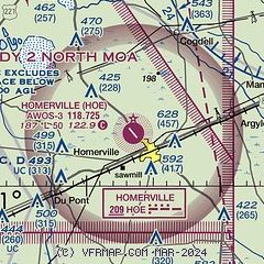
|
| Airport distance calculator |
|---|
|
|
| Sunrise and sunset |
|---|
|
Times for 27-Apr-2026
| | Local
(UTC-4) | | Zulu
(UTC) |
|---|
| Morning civil twilight | | 06:26 | | 10:26 |
| Sunrise | | 06:51 | | 10:51 |
| Sunset | | 20:06 | | 00:06 |
| Evening civil twilight | | 20:32 | | 00:32 |
|
| Current date and time |
|---|
| Zulu (UTC) | 28-Apr-2026 02:52:22 |
|---|
| Local (UTC-4) | 27-Apr-2026 22:52:22 |
|---|
|
| METAR |
|---|
| KHOE | 280235Z AUTO 09005KT 10SM CLR 17/12 A3018 RMK AO2 T01720127
|
|
| TAF |
|---|
KVAD
23nm W | 271730Z 2717/2822 06010G20KT 9999 OVC025 QNH3010INS BECMG 2717/2718 06010G15KT 9999 SCT040 QNH3003INS BECMG 2801/2802 10010G15KT 9999 SKC 510006 QNH3006INS BECMG 2807/2808 10003KT 8000 BR SCT007 510006 QNH3010INS BECMG 2812/2813 10003KT 9999 NSW SKC 510006 510606 QNH3015INS BECMG 2815/2816 12006KT 9999 FEW050 SCT250 QNH3003INS TX28/2720Z TN14/2810Z
|
|
| NOTAMs |
|---|
NOTAMs are issued by the DoD/FAA and will open in a separate window not controlled by AirNav.
|
|


