FAA INFORMATION EFFECTIVE 16 APRIL 2026
Location
| FAA Identifier: | CNW |
| Lat/Long: | 31-38-16.1000N 097-04-26.9000W
31-38.268333N 097-04.448333W
31.6378056,-97.0741389
(estimated) |
| Elevation: | 470.2 ft. / 143.3 m (surveyed) |
| Variation: | 04E (2015) |
| From city: | 8 miles NE of WACO, TX |
| Time zone: | UTC -5 (UTC -6 during Standard Time) |
| Zip code: | 76705 |
Airport Operations
| Airport use: | Open to the public |
| Activation date: | 05/1942 |
| Control tower: | yes |
| ARTCC: | FORT WORTH CENTER |
| FSS: | FORT WORTH FLIGHT SERVICE STATION |
| NOTAMs facility: | FTW (NOTAM-D service available) |
| Attendance: | MON-FRI 0600-1800 |
| Wind indicator: | lighted |
| Segmented circle: | yes |
| Lights: | WHEN ATCT CLSD MIRL RWY 17L/35R PRESET LOW INTST; TO INCR INTST & ACTVT MALSR RWY 17L & PAPI RWY 17L & 35R - 121.7. |
| Beacon: | white-green (lighted land airport)
Operates sunset to sunrise. |
Airport Communications
| CTAF: | 124.0 |
| UNICOM: | 122.95 |
| WX AWOS-3PT: | 134.225 (254-867-3880) |
| TSTC GROUND: | 121.7 [0700-2300] |
| TSTC TOWER: | 124.0 255.7 [0700-2300] |
| WACO APPROACH: | 127.65 |
| WACO DEPARTURE: | 126.125 |
| ASR: | 132.525 |
| WX ASOS at ACT (8 nm W): | PHONE 254-218-3267 |
| WX AWOS-3PT at PWG (15 nm SW): | 135.525 (254-848-4581) |
- APCH/DEP CTL SVC PRVDD BY FORT WORTH ARTCC (ZFW) ON FREQS 133.3/269.5 (WACO RCAG) WHEN WACO APCH CTL (ACT) CLSD.
Nearby radio navigation aids
| VOR radial/distance | | VOR name | | Freq | | Var |
|---|
| ACTr089/10.1 | | WACO VORTAC | | 115.30 | | 09E |
| NDB name | | Hdg/Dist | | Freq | | Var | | ID |
|---|
| ROBINSON | | 355/8.0 | | 400 | | 03E | | ROB | .-. --- -... |
Airport Services
| Fuel available: | 100LL JET-A |
| Parking: | tiedowns |
| Airframe service: | MINOR |
| Powerplant service: | MINOR |
Runway Information
Runway 17L/35R
| Dimensions: | 8600 x 150 ft. / 2621 x 46 m |
| Surface: | asphalt, in excellent condition |
| Weight bearing capacity: | | Single wheel: | 50.0 | | Double wheel: | 200.0 | | Double tandem: | 450.0 |
|
| Runway edge lights: | medium intensity |
| RUNWAY 17L | | RUNWAY 35R |
| Latitude: | 31-39.095798N | | 31-37.678707N |
| Longitude: | 097-04.428717W | | 097-04.357763W |
| Elevation: | 469.8 ft. | | 456.0 ft. |
| Traffic pattern: | left | | right |
| Runway heading: | 174 magnetic, 178 true | | 354 magnetic, 358 true |
| Markings: | precision, in good condition | | precision, in good condition |
| Visual slope indicator: | 4-light PAPI on right (3.00 degrees glide path) | | 4-light PAPI on left (3.00 degrees glide path) |
| Approach lights: | MALSR: 1,400 foot medium intensity approach lighting system with runway alignment indicator lights | | |
| Touchdown point: | yes, no lights | | yes, no lights |
| Instrument approach: | ILS | | |
| Obstructions: | 44 ft. trees, 1929 ft. from runway, 790 ft. left and right of centerline, 39:1 slope to clear | | 67 ft. trees, 2515 ft. from runway, 750 ft. left and right of centerline, 34:1 slope to clear |
Runway 17R/35L
| Dimensions: | 6291 x 75 ft. / 1917 x 23 m |
| Surface: | concrete, in good condition |
| Weight bearing capacity: | | Single wheel: | 25.0 | | Double wheel: | 76.0 | | Double tandem: | 140.0 |
|
| RUNWAY 17R | | RUNWAY 35L |
| Latitude: | 31-38.625593N | | 31-37.588945N |
| Longitude: | 097-04.550002W | | 097-04.497940W |
| Elevation: | 466.6 ft. | | 459.6 ft. |
| Traffic pattern: | right | | left |
| Runway heading: | 174 magnetic, 178 true | | 354 magnetic, 358 true |
| Markings: | nonprecision, in fair condition | | nonprecision, in fair condition |
| Touchdown point: | yes, no lights | | yes, no lights |
| Obstructions: | none | | 48 ft. trees, 1560 ft. from runway, 410 ft. left and right of centerline, 28:1 slope to clear |
Airport Ownership and Management from official FAA records
| Ownership: | Publicly-owned |
| Owner: | TEXAS STATE TECH COLLEGE
3801 CAMPUS DRIVE
WACO, TX 76705
Phone 254-799-3611 |
| Manager: | GORDON ROWELL
3801 CAMPUS DRIVE
WACO, TX 76705
Phone 254-867-2280 |
Additional Remarks
| A46-17R | 17R/35L GREEN CNTRLN REFLECTORS ALONG FULL LENGTH OF RWY. |
| A46-35L | GREEN CNTRLN REFLECTORS ALONG FULL LENGTH OF RWY. |
| - | EXTSV FLT TRNG IN CLASS D AIRSPACE SFC TO 3000 FT AGL. |
| - | APU AVBL FOR JET ACFT. |
| - | RWY 17R-35L NOT LGTD. MAY BE USED FOR TAXI AND HEL OPNS. |
| - | AMGR CELL 910-578-8509. |
Instrument Procedures
NOTE: All procedures below are presented as PDF files. If you need a reader for these files, you should download the free Adobe Reader.NOT FOR NAVIGATION. Please procure official charts for flight.
FAA instrument procedures published for use from 16 April 2026 at 0901Z to 14 May 2026 at 0900Z.
IAPs - Instrument Approach Procedures |
|---|
| ILS OR LOC RWY 17L | |
download (289KB) |
| RNAV (GPS) RWY 17L | |
download (227KB) |
| RNAV (GPS) RWY 35R | |
download (207KB) |
| NDB RWY 35R | |
download (199KB) |
| Radar Approach Procedures available | |
download (208KB) |
| NOTE: Special Alternate Minimums apply | |
download (118KB) |
| NOTE: Special Take-Off Minimums/Departure Procedures apply | |
download (313KB) |
Other nearby airports with instrument procedures:
KACT - Waco Regional Airport (8 nm W)
KPWG - Mc Gregor Executive Airport (15 nm SW)
T15 - Marlin Airport (21 nm SE)
KINJ - Hillsboro Municipal Airport (27 nm N)
KLXY - Mexia-Limestone County Airport (29 nm E)
|
|

Road maps at:
MapQuest
Bing
Google
| Aerial photo |
|---|
WARNING: Photo may not be current or correct
 Photo by J. Gary Hendricks
Photo taken 01-Aug-2010
looking south.
Photo by J. Gary Hendricks
Photo taken 01-Aug-2010
looking south.
Do you have a better or more recent aerial photo of TSTC Waco Airport that you would like to share? If so, please send us your photo.
|
| Sectional chart |
|---|
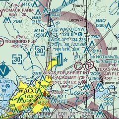
|
 Download PDF
of official airport diagram from the FAA
| Airport distance calculator |
|---|
|
|
| Sunrise and sunset |
|---|
|
Times for 29-Apr-2026
| | Local
(UTC-5) | | Zulu
(UTC) |
|---|
| Morning civil twilight | | 06:20 | | 11:20 |
| Sunrise | | 06:46 | | 11:46 |
| Sunset | | 20:06 | | 01:06 |
| Evening civil twilight | | 20:31 | | 01:31 |
|
| Current date and time |
|---|
| Zulu (UTC) | 29-Apr-2026 21:36:06 |
|---|
| Local (UTC-5) | 29-Apr-2026 16:36:06 |
|---|
|
| METAR |
|---|
| KCNW | 292055Z 01008KT 4SM BR OVC010 16/14 A2991
|
KACT
8nm W | 292051Z 34008KT 10SM OVC012 17/14 A2993 RMK AO2 LTG DSNT W AND NW PRESRR SLP130 T01670139 55008
|
KPWG
16nm SW | 292056Z AUTO 35005G14KT 10SM OVC009 16/16 A2994 RMK AO2 LTG DSNT N AND NW CIG 009V012 SLP132 T01610156 55008
|
|
| TAF |
|---|
KACT
8nm W | 291742Z 2918/3018 01010KT 3SM BR OVC007 TEMPO 2918/2920 2SM BR OVC003 FM292000 36009KT 5SM BR VCTS OVC015CB TEMPO 2921/2923 5SM -TSRA OVC015CB FM300000 01005KT 5SM BR OVC008 FM301100 05011KT 2SM BR VCSH OVC004
|
|
| NOTAMs |
|---|
NOTAMs are issued by the DoD/FAA and will open in a separate window not controlled by AirNav.
|
|


