FAA INFORMATION EFFECTIVE 19 MARCH 2026
Location
| FAA Identifier: | CNY |
| Lat/Long: | 38-45-27.4710N 109-45-12.4650W
38-45.457850N 109-45.207750W
38.7576308,-109.7534625
(estimated) |
| Elevation: | 4579.2 ft. / 1395.7 m (surveyed) |
| Variation: | 10E (2020) |
| From city: | 15 miles NW of MOAB, UT |
| Time zone: | UTC -6 (UTC -7 during Standard Time) |
| Zip code: | 84532 |
Airport Operations
| Airport use: | Open to the public |
| Activation date: | 08/1963 |
| Control tower: | no |
| ARTCC: | DENVER CENTER |
| FSS: | CEDAR CITY FLIGHT SERVICE STATION |
| NOTAMs facility: | CNY (NOTAM-D service available) |
| Attendance: | MAR-OCT 0800-1800, NOV-FEB 0900-1700 |
| Wind indicator: | lighted |
| Segmented circle: | yes |
| Lights: | ACTVT REIL RWY 03 & 21; MIRL RWY 03/21 - CTAF. PAPI RWY 03 & 21 ON CONSLY DURG DALGT HRS; ACTVT SS-SR - CTAF. |
| Beacon: | white-green (lighted land airport) |
| Landing fee: | yes |
| Fire and rescue: | ARFF index A |
Airport Communications
| CTAF/UNICOM: | 122.8 |
| WX ASOS: | 118.525 (435-259-8576) |
- APCH/DEP CTL SVC PRVDD BY DENVER ARTCC (ZDV) ON FREQS 134.5/327.8 (GRAND MESA/B/ RCAG).
- COMMUNICATIONS PRVDD BY CEDAR CITY RADIO ON FREQ 122.3 (MOAB RCO).
Nearby radio navigation aids
| VOR radial/distance | | VOR name | | Freq | | Var |
|---|
| OAB at field | | MOAB VOR/DME | | 109.80 | | 10E |
Airport Services
| Fuel available: | 100LL JET-A |
| Parking: | hangars and tiedowns |
| Airframe service: | MINOR |
| Powerplant service: | MINOR |
| Bulk oxygen: | HIGH/LOW |
Runway Information
Runway 3/21
| Dimensions: | 7360 x 100 ft. / 2243 x 30 m |
| Surface: | asphalt/grooved, in good condition |
| Weight bearing capacity: | |
| Runway edge lights: | medium intensity |
| RUNWAY 3 | | RUNWAY 21 |
| Latitude: | 38-44.815930N | | 38-45.746210N |
| Longitude: | 109-45.804933W | | 109-44.812012W |
| Elevation: | 4552.7 ft. | | 4557.9 ft. |
| Traffic pattern: | left | | right |
| Runway heading: | 030 magnetic, 040 true | | 210 magnetic, 220 true |
| Displaced threshold: | no | | 260 ft. |
| Declared distances: | TORA:7101 TODA:7361 ASDA:7101 LDA:7101 | | TORA:7361 TODA:7361 ASDA:7361 LDA:7101 |
| Markings: | nonprecision, in good condition | | nonprecision, in good condition |
| Visual slope indicator: | 4-light PAPI on left (3.35 degrees glide path) | | 4-light PAPI on left (3.00 degrees glide path)
PAPI DOES NOT PROVD OBST CLNC BYD 2.9 NM FM RWY THLD. |
| Runway end identifier lights: | yes | | yes |
| Touchdown point: | yes, no lights | | yes, no lights |
| Obstructions: | none | | 36 ft. pline, 912 ft. from runway, 464 ft. left of centerline, 19:1 slope to clear |
Runway 15/33
| Dimensions: | 2121 x 60 ft. / 646 x 18 m |
| Surface: | gravel, in good condition |
| Operational restrictions: | RWY 15/33 NOT AVBL FOR PART 121/PART 380 OPS WITH SKED PAX CARRYING OPS MORE THAN 9 PAX SEATS AND NON-SKED PAX CARRYING OPS MORE THAN 30 PAX SEATS. |
| RUNWAY 15 | | RUNWAY 33 |
| Latitude: | 38-46.232767N | | 38-45.909817N |
| Longitude: | 109-44.942975W | | 109-44.772850W |
| Elevation: | 4579.2 ft. | | 4563.5 ft. |
| Traffic pattern: | left | | left |
| Runway heading: | 148 magnetic, 158 true | | 328 magnetic, 338 true |
| Declared distances: | TORA:2000 TODA:2000 ASDA:2000 LDA:2000 | | TORA:2000 TODA:2000 ASDA:2000 LDA:2000 |
| Markings: | none, in poor condition | | none, in poor condition |
| Touchdown point: | yes, no lights | | yes, no lights |
Airport Ownership and Management from official FAA records
| Ownership: | Publicly-owned |
| Owner: | GRAND COUNTY
125 E. CENTER
MOAB, UT 84532
Phone (435) 259-1347 |
| Manager: | TAMMY HOWLAND
110 W. AVIATION WAY
MOAB, UT 84532
Phone 435-259-4120 |
Additional Remarks
| A39-03/21 | PCR VALUE: 327/F/D/X/T |
Instrument Procedures
NOTE: All procedures below are presented as PDF files. If you need a reader for these files, you should download the free Adobe Reader.NOT FOR NAVIGATION. Please procure official charts for flight.
FAA instrument procedures published for use from 19 March 2026 at 0901Z to 16 April 2026 at 0900Z.
IAPs - Instrument Approach Procedures |
|---|
| RNAV (GPS) RWY 03 **CHANGED** | |
download (241KB) |
| VOR-A **CHANGED** | |
download (187KB) |
| NOTE: Special Alternate Minimums apply | |
download (120KB) |
| NOTE: Special Take-Off Minimums/Departure Procedures apply | |
download (390KB) |
Other nearby airports with instrument procedures:
U34 - Green River Municipal Airport (25 nm NW)
U64 - Monticello Airport (53 nm S)
KGJT - Grand Junction Regional Airport (61 nm E)
KAIB - Hopkins Field Airport (64 nm SE)
69V - Huntington Municipal Airport (65 nm NW)
|
|

Road maps at:
MapQuest
Bing
Google
| Aerial photo |
|---|
WARNING: Photo may not be current or correct
 Photo by Max Grogan
Photo taken 07-Sep-2009
Photo by Max Grogan
Photo taken 07-Sep-2009
Do you have a better or more recent aerial photo of Canyonlands Regional Airport that you would like to share? If so, please send us your photo.
|
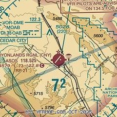
| Sectional chart |
|---|
|
| Airport distance calculator |
|---|
|
|
| Sunrise and sunset |
|---|
|
Times for 10-Apr-2026
| | Local
(UTC-6) | | Zulu
(UTC) |
|---|
| Morning civil twilight | | 06:24 | | 12:24 |
| Sunrise | | 06:51 | | 12:51 |
| Sunset | | 19:50 | | 01:50 |
| Evening civil twilight | | 20:17 | | 02:17 |
|
| Current date and time |
|---|
| Zulu (UTC) | 11-Apr-2026 01:27:18 |
|---|
| Local (UTC-6) | 10-Apr-2026 19:27:18 |
|---|
|
| METAR |
|---|
| KCNY | 110053Z AUTO 21013KT 9SM CLR 23/M07 A2988 RMK AO2 SLP078 T02281072
|
|
| TAF |
|---|
| KCNY | 101835Z 1019/1118 21015G23KT P6SM SCT110 BKN250 FM110300 22009KT P6SM SCT090 BKN250 FM110600 18007KT P6SM FEW140 SCT250 FM111700 19017KT P6SM SCT060 BKN090
|
|
| NOTAMs |
|---|
NOTAMs are issued by the DoD/FAA and will open in a separate window not controlled by AirNav.
|
|


