FAA INFORMATION EFFECTIVE 16 APRIL 2026
Location
| FAA Identifier: | DLG |
| Lat/Long: | 59-02-40.8000N 158-30-19.8000W
59-02.680000N 158-30.330000W
59.0446667,-158.5055000
(estimated) |
| Elevation: | 82 ft. / 25.0 m (surveyed) |
| Variation: | 11E (2025) |
| From city: | 2 miles W of DILLINGHAM, AK |
| Time zone: | UTC -8 (UTC -9 during Standard Time) |
| Zip code: | 99576 |
Airport Operations
| Airport use: | Open to the public |
| Activation date: | 11/1950 |
| Control tower: | no |
| ARTCC: | ANCHORAGE CENTER |
| FSS: | DILLINGHAM FLIGHT SERVICE STATION (on field) [907-842-5275] |
| Alternate FSS: | ENA KENAI FLIGHT SERVICE STATION [1-866-864-1737] |
| NOTAMs facility: | DLG (NOTAM-D service available) |
| Attendance: | 0700-1730
AFT HR ARPT/MAINT SVC, WILDLIFE CTL, SN REMOVAL, COND RPRTG PPR - AMGR. |
| Wind indicator: | yes |
| Segmented circle: | yes |
| Lights: | WHEN DLG FSS CLSD ACTVT ODALS RWY 19; PAPI RWY 01; VASI RWY 19; HIRL RWY 01/19 - CTAF. |
| Beacon: | white-green (lighted land airport)
ON TWR AT ARFF BLDG; OPS UNMNT WHEN DLG FSS CLSD. Operates sunset to sunrise. |
| Fire and rescue: | ARFF index B |
| Airline operations: | CLSD TO ACR OPS MORE THAN 30 PAX SEATS EXC PPR IN WRITING - AMGR BOX 250 DILLINGHAM, AK 99576. |
Airport Communications
| CTAF: | 123.6 |
| WX AWOS-3P: | 125.0 (907-842-2137) |
| WX AWOS-3P at CLP (13 nm S): | 121.45 (907-868-7311) |
| WX AWOS-3P at MBA (14 nm SW): | 120.625 (907-621-7983) |
- APCH/DEP SVC PRVDD BY ANCHORAGE ARTCC ON FREQS 132.75/282.35 (DILLINGHAM RCAG).
- DLG AFIS ON FREQUENCY 125.0. OPERATES SAME HRS AS DLG FSS, 0745-2145; OT CTC KENAI FSS.
- COMMUNICATIONS PRVDD BY DILLINGHAM FSS ON FREQ 123.6 (CTAF).
Nearby radio navigation aids
| VOR radial/distance | | VOR name | | Freq | | Var |
|---|
| DLGr010/3.4 | | DILLINGHAM VOR/DME | | 116.40 | | 15E |
Airport Services
| Fuel available: | 100LL JET-A |
| Parking: | tiedowns |
| Airframe service: | MINOR |
| Powerplant service: | MINOR |
Runway Information
Runway 1/19
| Dimensions: | 6400 x 150 ft. / 1951 x 46 m |
| Surface: | asphalt/grooved, in good condition |
| Weight bearing capacity: | | Single wheel: | 120.0 | | Double wheel: | 219.0 | | Double tandem: | 324.0 |
|
| Runway edge lights: | high intensity
LGTS 30 IN HIGH. |
| RUNWAY 1 | | RUNWAY 19 |
| Latitude: | 59-02.210227N | | 59-03.150647N |
| Longitude: | 158-30.785508W | | 158-29.875933W |
| Elevation: | 74.6 ft. | | 65.0 ft. |
| Traffic pattern: | left | | right |
| Runway heading: | 015 magnetic, 026 true | | 195 magnetic, 206 true |
| Declared distances: | TORA:6400 TODA:6400 ASDA:6400 LDA:6400 | | TORA:6400 TODA:6400 ASDA:6400 LDA:6400 |
| Markings: | nonprecision, in good condition | | nonprecision, in good condition |
| Visual slope indicator: | 4-light PAPI on left (3.00 degrees glide path) | | 4-box VASI on left (3.00 degrees glide path) |
| Approach lights: | | | ODALS: omnidirectional approach lighting system |
| Runway end identifier lights: | | | yes |
| Touchdown point: | yes, no lights | | yes, no lights |
| Instrument approach: | MLS | | LOC/DME |
| Obstructions: | none | | 79 ft. trees, 1789 ft. from runway, 273 ft. right of centerline, 20:1 slope to clear |
Airport Ownership and Management from official FAA records
| Ownership: | Publicly-owned |
| Owner: | ALASKA DOT&PF CENTRAL REGION
P O BOX 196900
ANCHORAGE, AK 99519-6900
Phone 907-269-0555 |
| Manager: | KEVIN HARDIN
BOX 250
DILLINGHAM, AK 99576
Phone 907-842-5511 |
Additional Remarks
| A39-01/19 | PCR VALUE: 600/F/C/X/T |
| - | FUEL - 907-842-1234/2400; AFT HR - 907-843-1590/907-252-7625. |
| - | LOCK WHEELED TURNS NA. |
| - | AWOS SW WIND READG UNRELBL. |
| - | TSA REGULATED ARPT; SEE 49 CFR 1542. GATES & DOORS MUST BE SECURED ALL TIMES. TSNT OR UNFAMILIAR PILOTS INFO - AMGR. |
| - | INCRD BIRD ACT SPRING & FALL. |
| - | PPR FOR HAZ RPRTG RWY, TWY OR RAMP SNOW CTL. |
| - | RWY SAFETY AREA S 3600 FT X 300 FT; N 3289 FT X 200 FT. |
| - | TWY, RAMP OR RSA TKOF OR LDG NA. |
| - | ARFF EQUIP AVBL DURG ACR ACT ONLY. |
| - | PAEW ON RWY PSBL ANY TIME. |
| - | TSNT PRKG MKD WITH GREEN CONES. |
| - | WX CAMERA AVBL ON INTERNET AT HTTPS://WEATHERCAMS.FAA.GOV/. |
| - | ARPT SAND LRGR GRADATION THAN FAA RCMDD/SEE AC150/5200-30. |
Instrument Procedures
NOTE: All procedures below are presented as PDF files. If you need a reader for these files, you should download the free Adobe Reader.NOT FOR NAVIGATION. Please procure official charts for flight.
FAA instrument procedures published for use from 16 April 2026 at 0901Z to 14 May 2026 at 0900Z.
IAPs - Instrument Approach Procedures |
|---|
| RNAV (RNP) Y RWY 01 | |
download (244KB) |
| RNAV (RNP) Y RWY 19 | |
download (283KB) |
| RNAV (GPS) Z RWY 01 | |
download (278KB) |
| RNAV (GPS) Z RWY 19 | |
download (246KB) |
| LOC RWY 19 | |
download (334KB) |
| VOR RWY 01 | |
download (297KB) |
| NOTE: Special Alternate Minimums apply | |
download (173KB) |
| NOTE: Special Take-Off Minimums/Departure Procedures apply | |
download (397KB) |
Other nearby airports with instrument procedures:
PFCL - Clarks Point Airport (13 nm S)
PAMB - Manokotak Airport (14 nm SW)
PANW - New Stuyahok Airport (42 nm NE)
PFWS - South Naknek Nr 2 Airport (51 nm SE)
PAJZ - Koliganek Airport (56 nm NE)
|
|

Road maps at:
MapQuest
Bing
Google
| Aerial photo |
|---|
WARNING: Photo may not be current or correct
 Photo by LL
Photo taken 21-Jun-2013
looking south.
Photo by LL
Photo taken 21-Jun-2013
looking south.
Do you have a better or more recent aerial photo of Dillingham Airport that you would like to share? If so, please send us your photo.
|
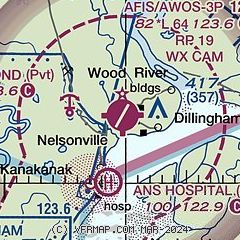
| Sectional chart |
|---|
|
| Airport distance calculator |
|---|
|
|
| Sunrise and sunset |
|---|
|
Times for 18-Apr-2026
| | Local
(UTC-8) | | Zulu
(UTC) |
|---|
| Morning civil twilight | | 06:26 | | 14:26 |
| Sunrise | | 07:12 | | 15:12 |
| Sunset | | 21:55 | | 05:55 |
| Evening civil twilight | | 22:40 | | 06:40 |
|
| Current date and time |
|---|
| Zulu (UTC) | 18-Apr-2026 17:54:18 |
|---|
| Local (UTC-8) | 18-Apr-2026 09:54:18 |
|---|
|
| METAR |
|---|
| PADL | 181709Z 20007KT 3SM BR OVC004 M04/M04 A3002 RMK AO2 $
|
PFCL
13nm S | 181656Z AUTO 18008KT 5SM -SN BR OVC004 M03/M03 A3003 RMK AO2 SLP161 P0000 T10331033 FZRANO
|
PAMB
17nm W | 181735Z AUTO 18005KT 2SM -SN BR OVC003 M03/M03 A3002 RMK AO2 VIS 1 1/4V3 P0000 FZRANO
|
|
| TAF |
|---|
| PADL | 181127Z 1812/1912 20007KT 6SM BR BKN003 TEMPO 1812/1816 1SM BR OVC002 FM181800 16006KT P6SM SCT003 BKN015 FM182100 14008KT P6SM VCSH SCT015 BKN030 FM190000 13010KT 5SM -RASN BR SCT007 BKN015 FM190600 13015KT 3SM -RASN BR BKN007
|
|
| NOTAMs |
|---|
NOTAMs are issued by the DoD/FAA and will open in a separate window not controlled by AirNav.
|
|

