FAA INFORMATION EFFECTIVE 17 APRIL 2025
Location
| FAA Identifier: | DNN |
| Lat/Long: | 34-43-22.5800N 084-52-12.8690W
34-43.376333N 084-52.214483W
34.7229389,-84.8702414
(estimated) |
| Elevation: | 709 ft. / 216.1 m (surveyed) |
| Variation: | 03W (2000) |
| From city: | 6 miles SE of DALTON, GA |
| Time zone: | UTC -4 (UTC -5 during Standard Time) |
| Zip code: | 30721 |
Airport Operations
| Airport use: | Open to the public |
| Activation date: | 12/1944 |
| Control tower: | no |
| ARTCC: | ATLANTA CENTER |
| FSS: | MACON FLIGHT SERVICE STATION |
| NOTAMs facility: | DNN (NOTAM-D service available) |
| Attendance: | SUN 1300-1700, ALL MON-SAT 0800-1700
OTHER HOURS BY REQUEST, CLOSED MAJOR HOLIDAYS. |
| Wind indicator: | lighted |
| Segmented circle: | yes |
| Lights: | MALSR RWY 14 OPR DUSK-DAWN WHEN THE VIS IS LESS THAN 3 MILES AND/OR THE CEILING IS LESS THAN 1000 FT, OTR TIMES - CTAF. HIRL RWY 14/32 OPR DUSK-DAWN, OTR TIMES - CTAF. |
| Beacon: | white-green (lighted land airport)
Operates sunset to sunrise. |
Airport Communications
| CTAF/UNICOM: | 122.975 |
| WX AWOS-3PT: | 127.65 (706-278-7010) |
| CHATTANOOGA APPROACH: | 125.1 |
| CHATTANOOGA DEPARTURE: | 125.1 |
| CLEARANCE DELIVERY: | 120.25 |
| WX AWOS-3PT at CZL (16 nm S): | 119.975 (706-578-1205) |
| WX AWOS-3 at 49A (18 nm E): | 118.075 (706 276-4513) |
- APCH/DEP SVC PRVDD BY ATLANTA ARTCC ON FREQS 124.5/270.325 (GADSDEN RCAG) WHEN CHATTANOOGA APCH CTL CLSD.
Nearby radio navigation aids
| VOR radial/distance | | VOR name | | Freq | | Var |
|---|
| RMGr019/35.8 | | ROME VORTAC | | 115.40 | | 01E |
| NDB name | | Hdg/Dist | | Freq | | Var | | ID |
|---|
| DAISY | | 154/30.1 | | 341 | | 02W | | CQN | -.-. --.- -. |
Airport Services
| Fuel available: | 100LL JET-A+ |
| Parking: | hangars and tiedowns |
| Airframe service: | MAJOR |
| Powerplant service: | MAJOR |
| Bottled oxygen: | NONE |
| Bulk oxygen: | NONE |
Runway Information
Runway 14/32
| Dimensions: | 5496 x 100 ft. / 1675 x 30 m |
| Surface: | asphalt, in good condition |
| Weight bearing capacity: | | Single wheel: | 30.0 | | Double wheel: | 42.0 | | Double tandem: | 80.0 |
|
| Runway edge lights: | high intensity |
| RUNWAY 14 | | RUNWAY 32 |
| Latitude: | 34-43.710105N | | 34-43.042535N |
| Longitude: | 084-52.585473W | | 084-51.843530W |
| Elevation: | 708.0 ft. | | 691.5 ft. |
| Traffic pattern: | left | | left |
| Runway heading: | 140 magnetic, 137 true | | 320 magnetic, 317 true |
| Markings: | precision, in fair condition | | precision, in fair condition |
| Visual slope indicator: | 4-light PAPI on left (3.00 degrees glide path)
RY 14 PAPI AND ILS GLIDEPATH NOT COINCIDENT. | | 4-light PAPI on left (3.05 degrees glide path)
RY 32 PAPI UNUSBL BYD 5 DEGREES RIGHT OF RY CNTRLN. |
| Approach lights: | MALSR: 1,400 foot medium intensity approach lighting system with runway alignment indicator lights | | |
| Touchdown point: | yes, no lights | | yes, no lights |
| Instrument approach: | ILS | | |
| Obstructions: | 83 ft. trees, 1198 ft. from runway, 600 ft. right of centerline, 12:1 slope to clear | | 199 ft. trees, 3780 ft. from runway, 774 ft. right of centerline, 18:1 slope to clear |
Airport Ownership and Management from official FAA records
| Ownership: | Publicly-owned |
| Owner: | CITY OF DALTON
PO BOX 1205
DALTON, GA 30720
Phone 706-259-2200 |
| Manager: | ANDREW WIERSMA
4483 AIRPORT ROAD, PO BOX 1205
DALTON, GA 30721
Phone 706-259-2200 |
Additional Remarks
| - | DEER AND WILDLIFE ON OR INVOF ARPT. |
| - | FOR CD CTC CHATTANOOGA APCH AT 423-855-6478, WHEN APCH CLSD CTC ATLANTA ARTCC AT 770-210-7692. |
Instrument Procedures
NOTE: All procedures below are presented as PDF files. If you need a reader for these files, you should download the free Adobe Reader.NOT FOR NAVIGATION. Please procure official charts for flight.
FAA instrument procedures published for use from 17 April 2025 at 0901Z to 15 May 2025 at 0900z.
IAPs - Instrument Approach Procedures |
|---|
| ILS OR LOC RWY 14 | |
download (229KB) |
| RNAV (GPS) RWY 14 | |
download (251KB) |
| RNAV (GPS) RWY 32 | |
download (219KB) |
| NOTE: Special Alternate Minimums apply | |
download (160KB) |
| NOTE: Special Take-Off Minimums/Departure Procedures apply | |
download (344KB) |
Other nearby airports with instrument procedures:
KCZL - Tom B David Field Airport (16 nm S)
49A - Gilmer County Airport (18 nm E)
9A5 - Barwick Lafayette Airport (21 nm W)
KCHA - Lovell Field Airport (25 nm NW)
KJZP - Pickens County Airport (26 nm SE)
|
|

Road maps at:
MapQuest
Bing
Google
| Aerial photo |
|---|
WARNING: Photo may not be current or correct
 Photo by Tony Armour
Photo taken 15-Apr-2017
looking southeast.
Photo by Tony Armour
Photo taken 15-Apr-2017
looking southeast.
Do you have a better or more recent aerial photo of Dalton Municipal Airport that you would like to share? If so, please send us your photo.
|
| Sectional chart |
|---|
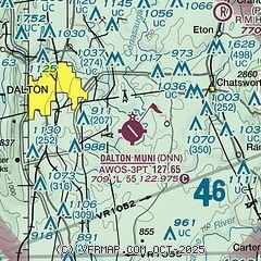
|
| Airport distance calculator |
|---|
|
|
| Sunrise and sunset |
|---|
|
Times for 04-May-2025
| | Local
(UTC-4) | | Zulu
(UTC) |
|---|
| Morning civil twilight | | 06:20 | | 10:20 |
| Sunrise | | 06:47 | | 10:47 |
| Sunset | | 20:26 | | 00:26 |
| Evening civil twilight | | 20:53 | | 00:53 |
|
| Current date and time |
|---|
| Zulu (UTC) | 04-May-2025 11:10:20 |
|---|
| Local (UTC-4) | 04-May-2025 07:10:20 |
|---|
|
| METAR |
|---|
KDNN
12nm W | 041055Z AUTO 00000KT 1 3/4SM BR OVC003 11/11 A2985 RMK AO2 T01130113
|
KCZL
16nm S | 041055Z AUTO 00000KT 10SM BKN007 OVC012 13/13 A2986 RMK AO2
|
K49A
18nm E | 041055Z AUTO 00000KT 5SM BR SCT017 10/10 A2987 RMK AO2
|
K9A5
21nm W | 041055Z AUTO 00000KT 1/4SM FG OVC001 10/10 A2987 RMK AO2 T01010101
|
|
| TAF |
|---|
KCHA
25nm NW | 040539Z 0406/0506 27005KT P6SM BKN020 FM041400 25005KT P6SM SCT025 FM041600 26008KT P6SM BKN040 FM041900 26008KT P6SM VCSH BKN040 FM050000 28004KT P6SM BKN035
|
|
| NOTAMs |
|---|
NOTAMs are issued by the DoD/FAA and will open in a separate window not controlled by AirNav.
|
|


