FAA INFORMATION EFFECTIVE 30 OCTOBER 2025
Location
| FAA Identifier: | DVL |
| Lat/Long: | 48-06-59.7270N 098-54-35.9570W
48-06.995450N 098-54.599283W
48.1165908,-98.9099881
(estimated) |
| Elevation: | 1469.4 ft. / 447.9 m (surveyed) |
| Variation: | 07E (2000) |
| From city: | 2 miles W of DEVILS LAKE, ND |
| Time zone: | UTC -6 (UTC -5 during Daylight Saving Time) |
| Zip code: | 58301 |
Airport Operations
| Airport use: | Open to the public |
| Control tower: | no |
| ARTCC: | MINNEAPOLIS CENTER |
| FSS: | GRAND FORKS FLIGHT SERVICE STATION |
| NOTAMs facility: | DVL (NOTAM-D service available) |
| Attendance: | 0700-1800
FOR ATNDT AFT HRS CALL 701-520-0229. |
| Wind indicator: | lighted |
| Segmented circle: | yes |
| Lights: | ACTVT OR INCR INTST MALSR RWY 31; REIL RWY 03, 13, & 21; PAPI RWY 13/31; HIRL RWY 13/31, MIRL RWY 03/21 - CTAF. |
| Beacon: | white-green (lighted land airport)
Operates sunset to sunrise. |
| Fire and rescue: | ARFF index A |
| Airline operations: | 48 HRS PPR FOR UNSKED ACFT OPS WITH MORE THAN 30 PSGRS CALL AMGR 701-662-5833.
SKED AIR CARRIER OPNS INVOLVING ACFT WITH MORE THAN 9 PSGRS ARE NOT AUTH IN EXCESS OF 15 MINS BFR OR AFT SKED ARR/DEP TIMES WO PRIOR COORD WTH ARPT MGR TO ENSURE THAT ARFF IS AVBL. |
Airport Communications
| CTAF/UNICOM: | 122.8 |
| WX AWOS-3PT: | 125.875 (701-662-7214) |
- COMMUNICATIONS PRVDD BY GRAND FORKS RADIO ON FREQ 122.3 (DEVILS LAKE RCO).
- APCH/DEP SVC PRVDD BY MINNEAPOLIS ARTCC (ZMP) ON FREQ 124.2/270.3 (WOODWORTH RCAG).
Airport Services
| Fuel available: | 100LL JET-A
A:FUEL AVBL IREG HRS CALL 701-520-0229; SELF SVC AVGAS AVBL H24. |
| Parking: | hangars and tiedowns |
| Airframe service: | MAJOR |
| Powerplant service: | MAJOR |
| Bottled oxygen: | NONE |
| Bulk oxygen: | NONE |
Runway Information
Runway 13/31
| Dimensions: | 6400 x 100 ft. / 1951 x 30 m |
| Surface: | asphalt/grooved, in good condition |
| Weight bearing capacity: | | Single wheel: | 75.0 | | Double wheel: | 130.0 | | Double tandem: | 190.0 |
|
| Runway edge lights: | high intensity |
| RUNWAY 13 | | RUNWAY 31 |
| Latitude: | 48-07.448102N | | 48-06.665050N |
| Longitude: | 098-55.185545W | | 098-54.135087W |
| Elevation: | 1469.4 ft. | | 1443.3 ft. |
| Traffic pattern: | left | | left |
| Runway heading: | 131 magnetic, 138 true | | 311 magnetic, 318 true |
| Declared distances: | TORA:6401 TODA:6401 ASDA:6401 LDA:6401 | | TORA:6401 TODA:6401 ASDA:6401 LDA:6401 |
| Markings: | nonprecision, in good condition | | precision, in good condition |
| Visual slope indicator: | 4-light PAPI on left (3.00 degrees glide path) | | 4-light PAPI on left (3.00 degrees glide path) |
| Approach lights: | | | MALSR: 1,400 foot medium intensity approach lighting system with runway alignment indicator lights |
| Runway end identifier lights: | yes | | |
| Touchdown point: | yes, no lights | | yes, no lights |
| Instrument approach: | | | ILS |
| Obstructions: | none | | 29 ft. bldg, 1400 ft. from runway, 650 ft. left of centerline, 41:1 slope to clear |
Runway 3/21
| Dimensions: | 4314 x 75 ft. / 1315 x 23 m |
| Surface: | asphalt, in good condition |
| Weight bearing capacity: | |
| Runway edge lights: | medium intensity |
| Operational restrictions: | RWY 03/21 NOT AVBL FOR PART 121/PART 380 OPS WITH SKED PAX CARRYING OPS MORE THAN 9 PAX SEATS AND NON-SKED PAX CARRYING OPS MORE THAN 30 PAX SEATS. |
| RUNWAY 3 | | RUNWAY 21 |
| Latitude: | 48-06.654127N | | 48-07.155292N |
| Longitude: | 098-54.883818W | | 098-54.133798W |
| Elevation: | 1449.9 ft. | | 1441.0 ft. |
| Traffic pattern: | left | | left |
| Runway heading: | 038 magnetic, 045 true | | 218 magnetic, 225 true |
| Declared distances: | TORA:4314 TODA:4314 ASDA:4314 LDA:4314 | | TORA:4314 TODA:4314 ASDA:4314 LDA:4314 |
| Markings: | nonprecision, in good condition | | nonprecision, in good condition |
| Visual slope indicator: | 2-light PAPI on left (3.00 degrees glide path) | | 2-light PAPI on left (3.00 degrees glide path) |
| Runway end identifier lights: | yes | | yes |
| Touchdown point: | yes, no lights | | yes, no lights |
| Obstructions: | 35 ft. road, 1119 ft. from runway, 384 ft. left of centerline, 26:1 slope to clear | | 38 ft. tree, 1523 ft. from runway, 131 ft. right of centerline, 40:1 slope to clear |
Airport Ownership and Management from official FAA records
| Ownership: | Publicly-owned |
| Owner: | DEVILS LAKE AIRPORT AUTHORITY
106 NATIONAL GUARD ST NW
DEVILS LAKE, ND 58301-8993
Phone 701-662-5833 |
| Manager: | SCOTT CRUSE
106 NATIONAL GUARD ST NW
DEVILS LAKE, ND 58301-8993
Phone 701-662-5833 |
Additional Remarks
| A39-13/31 | PCR VALUE: 337/F/D/X/T |
| A39-03/21 | PCR VALUE: 245/F/D/X/T |
| - | NUMEROUS WATERFOWL & OTHER BIRDS; DEER & JACK RABBITS ON & INVOF ARPT. |
| - | FOR CD IF UNA TO CTC ON FSS FREQ, CTC MINNEAPOLIS ARTCC AT 651-463-5588. |
Instrument Procedures
NOTE: All procedures below are presented as PDF files. If you need a reader for these files, you should download the free Adobe Reader.NOT FOR NAVIGATION. Please procure official charts for flight.
FAA instrument procedures published for use from 30 October 2025 at 0901Z to 27 November 2025 at 0900Z.
IAPs - Instrument Approach Procedures |
|---|
| ILS OR LOC RWY 31 | |
download (271KB) |
| RNAV (GPS) RWY 03 | |
download (253KB) |
| RNAV (GPS) RWY 13 | |
download (251KB) |
| RNAV (GPS) RWY 21 **CHANGED** | |
download (264KB) |
| RNAV (GPS) RWY 31 | |
download (257KB) |
| NOTE: Special Alternate Minimums apply | |
download (174KB) |
| NOTE: Special Take-Off Minimums/Departure Procedures apply | |
download (164KB) |
Other nearby airports with instrument procedures:
5L0 - Lakota Municipal Airport (24 nm E)
9D7 - Cando Municipal Airport (25 nm NW)
46D - Carrington Municipal Airport (41 nm S)
D55 - Robertson Field Airport (43 nm NE)
5H4 - Harvey Municipal Airport (45 nm SW)
|
|

Road maps at:
MapQuest
Bing
Google
| Aerial photo |
|---|
WARNING: Photo may not be current or correct

Do you have a better or more recent aerial photo of Devils Lake Regional Airport that you would like to share? If so, please send us your photo.
|
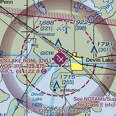
| Sectional chart |
|---|
|
| Airport distance calculator |
|---|
|
|
| Sunrise and sunset |
|---|
|
Times for 11-Nov-2025
| | Local
(UTC-6) | | Zulu
(UTC) |
|---|
| Morning civil twilight | | 07:04 | | 13:04 |
| Sunrise | | 07:37 | | 13:37 |
| Sunset | | 17:02 | | 23:02 |
| Evening civil twilight | | 17:36 | | 23:36 |
|
| Current date and time |
|---|
| Zulu (UTC) | 12-Nov-2025 00:40:10 |
|---|
| Local (UTC-6) | 11-Nov-2025 18:40:10 |
|---|
|
| METAR |
|---|
| KDVL | 112356Z AUTO 28011KT 10SM CLR 04/M06 A2980 RMK AO2 SLP111 T00441056 10089 20044 53022
|
|
| TAF |
|---|
| KDVL | 111911Z 1119/1218 30023G28KT P6SM FEW100 FM112200 30017G25KT P6SM FEW250 FM112300 30018KT P6SM FEW250 FM120600 28013KT P6SM SCT250
|
|
| NOTAMs |
|---|
NOTAMs are issued by the DoD/FAA and will open in a separate window not controlled by AirNav.
|
|

