FAA INFORMATION EFFECTIVE 14 MAY 2026
Location
| FAA Identifier: | E41 |
| Lat/Long: | 31-11-55.0490N 101-28-30.8820W
31-11.917483N 101-28.514700W
31.1986247,-101.4752450
(estimated) |
| Elevation: | 2705.7 ft. / 824.7 m (surveyed) |
| Variation: | 08E (2000) |
| From city: | 1 mile W of BIG LAKE, TX |
| Time zone: | UTC -5 (UTC -6 during Standard Time) |
| Zip code: | 76932 |
Airport Operations
| Airport use: | Open to the public |
| Activation date: | 09/1946 |
| Control tower: | no |
| ARTCC: | FORT WORTH CENTER |
| FSS: | SAN ANGELO FLIGHT SERVICE STATION |
| NOTAMs facility: | SJT (NOTAM-D service available) |
| Attendance: | UNATNDD |
| Wind indicator: | lighted |
| Segmented circle: | yes |
| Lights: | ACTVT PAPI RWY 16 & 34; MIRL RWY 16/34 - CTAF. |
| Beacon: | white-green (lighted land airport)
Operates sunset to sunrise. |
Airport Communications
| CTAF: | 122.9 |
| WX AWOS-3PT: | 118.4 (325-884-2770) |
- APCH/DEP CTL SVC PRVDD BY FORT WORTH ARTCC (ZFW) ON FREQS 126.15/322.55 (SAN ANGELO RCAG).
Airport Services
| Fuel available: | 100LL
100LL:FOR FUEL CALL 325-277-1551 |
| Parking: | hangars and tiedowns |
| Airframe service: | NONE |
| Powerplant service: | NONE |
| Bottled oxygen: | NONE |
| Bulk oxygen: | NONE |
Runway Information
Runway 16/34
| Dimensions: | 5035 x 50 ft. / 1535 x 15 m |
| Surface: | asphalt, in good condition
LOOSE STONES ON THE RWY. |
| Weight bearing capacity: | |
| Runway edge lights: | medium intensity |
| RUNWAY 16 | | RUNWAY 34 |
| Latitude: | 31-12.420305N | | 31-11.604207N |
| Longitude: | 101-28.458647W | | 101-28.279830W |
| Elevation: | 2695.6 ft. | | 2699.6 ft. |
| Traffic pattern: | right | | left |
| Runway heading: | 161 magnetic, 169 true | | 341 magnetic, 349 true |
| Displaced threshold: | 1005 ft. | | no |
| Markings: | nonprecision, in good condition | | nonprecision, in good condition |
| Visual slope indicator: | 2-light PAPI on left (3.00 degrees glide path) | | 2-light PAPI on left (3.50 degrees glide path) |
| Touchdown point: | yes, no lights | | yes, no lights |
| Obstructions: | none | | 44 ft. pole, 764 ft. from runway, 165 ft. left and right of centerline, 12:1 slope to clear |
Runway 9/27
| Dimensions: | 4001 x 60 ft. / 1220 x 18 m |
| Surface: | asphalt, in poor condition
SFC SEAL SPALLING. |
| RUNWAY 9 | | RUNWAY 27 |
| Latitude: | 31-11.851613N | | 31-11.744807N |
| Longitude: | 101-29.076532W | | 101-28.318988W |
| Elevation: | 2684.6 ft. | | 2698.9 ft. |
| Traffic pattern: | left | | right |
| Runway heading: | 091 magnetic, 099 true | | 271 magnetic, 279 true |
| Markings: | basic, in good condition | | basic, in good condition |
| Touchdown point: | yes, no lights | | yes, no lights |
| Obstructions: | none | | 61 ft. pole, 1606 ft. from runway, 58 ft. left of centerline, 23:1 slope to clear |
Airport Ownership and Management from official FAA records
| Ownership: | Publicly-owned |
| Owner: | REAGAN COUNTY
COURTHOUSE
BIG LAKE, TX 76932
Phone 325-884-2665 |
| Manager: | HEATH HOLT
P. O BOX 100
BIG LAKE, TX 76932
Phone 325-650-1314
COUNTY JUDGE. |
Additional Remarks
| - | FOR CD CTC FORT WORTH ARTCC AT 817-858-7584. |
Instrument Procedures
NOTE: All procedures below are presented as PDF files. If you need a reader for these files, you should download the free Adobe Reader.NOT FOR NAVIGATION. Please procure official charts for flight.
FAA instrument procedures published for use from 14 May 2026 at 0901Z to 11 June 2026 at 0900Z.
IAPs - Instrument Approach Procedures |
|---|
| RNAV (GPS) RWY 16 | |
download (203KB) |
| NOTE: Special Alternate Minimums apply | |
download (120KB) |
| NOTE: Special Take-Off Minimums/Departure Procedures apply | |
download (297KB) |
Other nearby airports with instrument procedures:
KOZA - Ozona Municipal Airport (31 nm SE)
KSJT - San Angelo Regional Airport/Mathis Field (51 nm E)
KSOA - Sonora Municipal Airport (56 nm SE)
KMAF - Midland International Air and Space Port Airport (58 nm NW)
KMDD - Midland Airpark (60 nm NW)
|
|

Road maps at:
MapQuest
Bing
Google
| Aerial photo |
|---|
WARNING: Photo may not be current or correct
 Photo courtesy of Bill Gunn, TxDOT Aviation Division
Photo taken 10-Nov-2005
Photo courtesy of Bill Gunn, TxDOT Aviation Division
Photo taken 10-Nov-2005
Do you have a better or more recent aerial photo of Reagan County Airport that you would like to share? If so, please send us your photo.
|
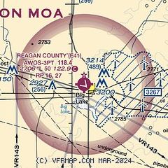
| Sectional chart |
|---|
|
| Airport distance calculator |
|---|
|
|
| Sunrise and sunset |
|---|
|
Times for 26-May-2026
| | Local
(UTC-5) | | Zulu
(UTC) |
|---|
| Morning civil twilight | | 06:18 | | 11:18 |
| Sunrise | | 06:45 | | 11:45 |
| Sunset | | 20:40 | | 01:40 |
| Evening civil twilight | | 21:08 | | 02:08 |
|
| Current date and time |
|---|
| Zulu (UTC) | 26-May-2026 12:22:42 |
|---|
| Local (UTC-5) | 26-May-2026 07:22:42 |
|---|
|
| METAR |
|---|
| KE41 | 261155Z AUTO 12012KT 10SM CLR 19/16 A2987 RMK AO2 LTG DSNT W THRU E T01860163 10201 20186
|
|
| NOTAMs |
|---|
NOTAMs are issued by the DoD/FAA and will open in a separate window not controlled by AirNav.
|
|


