FAA INFORMATION EFFECTIVE 14 MAY 2026
Location
| FAA Identifier: | MDD |
| Lat/Long: | 32-02-11.6536N 102-06-05.4992W
32-02.194227N 102-06.091653W
32.0365704,-102.1015276
(estimated) |
| Elevation: | 2805.4 ft. / 855.1 m (surveyed) |
| Variation: | 07E (2010) |
| From city: | 3 miles N of MIDLAND, TX |
| Time zone: | UTC -5 (UTC -6 during Standard Time) |
| Zip code: | 79705 |
Airport Operations
| Airport use: | Open to the public |
| Activation date: | 02/1943 |
| Control tower: | no |
| ARTCC: | FORT WORTH CENTER |
| FSS: | SAN ANGELO FLIGHT SERVICE STATION |
| NOTAMs facility: | MDD (NOTAM-D service available) |
| Attendance: | M-F 0600-2000, ALL S-S 0700-2000 |
| Wind indicator: | lighted |
| Segmented circle: | yes |
| Lights: | MIRL RWYS 07/25 & 16/34 PRESET LOW INTST; TO INCR INTST & ACTVT VASI RWY 25; PAPI RWYS 07, 16 & 34 - CTAF. |
| Beacon: | white-green (lighted land airport)
Operates sunset to sunrise. |
Airport Communications
| CTAF/UNICOM: | 122.7 |
| WX AWOS-3: | 118.125 (432-687-4605) |
| MIDLAND APPROACH: | 124.6 |
| MIDLAND DEPARTURE: | 124.6 |
| CLEARANCE DELIVERY: | 121.8 |
| WX ASOS at MAF (8 nm SW): | PHONE 432-201-2813 |
| WX ASOS at ODO (16 nm SW): | 119.275 (432-363-9719) |
- APCH/DEP SVC PRVDD BY FORT WORTH ARTCC (ZFW) ON FREQS 133.1/298.95 (MIDLAND RCAG) WHEN MIDLAND APCH CLSD.
Nearby radio navigation aids
| VOR radial/distance | | VOR name | | Freq | | Var |
|---|
| MAFr059/4.8 | | MIDLAND VORTAC | | 112.60 | | 11E |
| BGSr225/37.7 | | BIG SPRING VORTAC | | 117.20 | | 11E |
| NDB name | | Hdg/Dist | | Freq | | Var | | ID |
|---|
| FARLY | | 067/11.7 | | 326 | | 09E | | MA | -- .- |
Airport Services
| Fuel available: | 100LL JET-A
100LL:FOR FUEL AFT HRS CALL 432-685-7000. |
| Parking: | hangars and tiedowns |
| Airframe service: | MAJOR |
| Powerplant service: | MAJOR |
| Bottled oxygen: | HIGH |
| Bulk oxygen: | HIGH |
Runway Information
Runway 7/25
| Dimensions: | 5571 x 75 ft. / 1698 x 23 m |
| Surface: | asphalt/rubberized friction seal coat, in good condition |
| Weight bearing capacity: | |
| Runway edge lights: | medium intensity |
| RUNWAY 7 | | RUNWAY 25 |
| Latitude: | 32-02.217167N | | 32-02.455488N |
| Longitude: | 102-06.635667W | | 102-05.593967W |
| Elevation: | 2803.4 ft. | | 2789.9 ft. |
| Traffic pattern: | left | | right |
| Runway heading: | 068 magnetic, 075 true | | 248 magnetic, 255 true |
| Displaced threshold: | 550 ft. | | no |
| Declared distances: | TORA:5571 TODA:5571 ASDA:5571 LDA:5022 | | |
| Markings: | basic, in good condition | | nonprecision, in good condition |
| Visual slope indicator: | 2-light PAPI on left (3.00 degrees glide path) | | 4-box VASI on left (3.00 degrees glide path) |
| Touchdown point: | yes, no lights | | yes, no lights |
| Obstructions: | 33 ft. pole, 705 ft. from runway, 15:1 slope to clear
APCH SLOPE AT DSPLCD THR 38:1. | | 53 ft. pole, 2010 ft. from runway, 480 ft. right of centerline, 34:1 slope to clear |
Runway 16/34
| Dimensions: | 3977 x 75 ft. / 1212 x 23 m |
| Surface: | asphalt, in fair condition |
| Weight bearing capacity: | |
| Runway edge lights: | medium intensity |
| RUNWAY 16 | | RUNWAY 34 |
| Latitude: | 32-02.311843N | | 32-01.678497N |
| Longitude: | 102-06.159253W | | 102-05.959157W |
| Elevation: | 2799.8 ft. | | 2796.6 ft. |
| Traffic pattern: | left | | right |
| Runway heading: | 158 magnetic, 165 true | | 338 magnetic, 345 true |
| Markings: | basic, in good condition | | nonprecision, in good condition |
| Visual slope indicator: | 2-light PAPI on left (3.00 degrees glide path) | | 2-light PAPI on left (3.00 degrees glide path) |
| Touchdown point: | yes, no lights | | yes, no lights |
| Obstructions: | 15 ft. road, 495 ft. from runway, 19:1 slope to clear | | 38 ft. trees, 840 ft. from runway, 219 ft. right of centerline, 16:1 slope to clear |
Airport Ownership and Management from official FAA records
| Ownership: | Publicly-owned |
| Owner: | CITY OF MIDLAND
PO BOX 60305 A.T.S.
MIDLAND, TX 79711
Phone 432-560-2200 |
| Manager: | JUSTINE RUFF
PO BOX 60305
MIDLAND, TX 79711
Phone 432-560-2200
EXT 3001 |
Additional Remarks
| - | BIRDS INVOF ARPT (SEASONAL). |
| - | FOR CD WHEN 121.8 IS OTS CTC MIDLAND APCH AT 432-563-2123. WHEN APCH CLSD CTC FORT WORTH ARTCC AT 817-858-7584. |
| - | OPRS ON NON-PAVED SFCS ARE PROHIBITED WITHOUT 24 HR PPR. |
Instrument Procedures
NOTE: All procedures below are presented as PDF files. If you need a reader for these files, you should download the free Adobe Reader.NOT FOR NAVIGATION. Please procure official charts for flight.
FAA instrument procedures published for use from 14 May 2026 at 0901Z to 11 June 2026 at 0900Z.
IAPs - Instrument Approach Procedures |
|---|
| RNAV (GPS) RWY 25 | |
download (268KB) |
| RNAV (GPS) RWY 34 | |
download (234KB) |
| VOR RWY 25 | |
download (197KB) |
| VOR-A | |
download (172KB) |
| NOTE: Special Alternate Minimums apply | |
download (117KB) |
| NOTE: Special Take-Off Minimums/Departure Procedures apply | |
download (290KB) |
Other nearby airports with instrument procedures:
KMAF - Midland International Air and Space Port Airport (8 nm SW)
KODO - Odessa Airport-Schlemeyer Field (16 nm SW)
E11 - Andrews County Airport (28 nm NW)
KBPG - Big Spring/Mc Mahon-Wrinkle Airport (31 nm E)
KLUV - Lamesa Municipal Airport (44 nm N)
|
|

Road maps at:
MapQuest
Bing
Google
| Aerial photo |
|---|
WARNING: Photo may not be current or correct
 Photo by Gary Chambers
Photo taken 11-Jan-2005
Photo by Gary Chambers
Photo taken 11-Jan-2005
Do you have a better or more recent aerial photo of Midland Airpark that you would like to share? If so, please send us your photo.
|
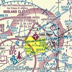
| Sectional chart |
|---|
|
| Airport distance calculator |
|---|
|
|
| Sunrise and sunset |
|---|
|
Times for 08-Jun-2026
| | Local
(UTC-5) | | Zulu
(UTC) |
|---|
| Morning civil twilight | | 06:15 | | 11:15 |
| Sunrise | | 06:43 | | 11:43 |
| Sunset | | 20:52 | | 01:52 |
| Evening civil twilight | | 21:20 | | 02:20 |
|
| Current date and time |
|---|
| Zulu (UTC) | 08-Jun-2026 13:26:13 |
|---|
| Local (UTC-5) | 08-Jun-2026 08:26:13 |
|---|
|
| METAR |
|---|
| KMDD | 081255Z AUTO 18016G20KT 7SM SCT011 23/20 A2991 RMK AO2 T02340203
|
KMAF
7nm SW | 081308Z 17020G27KT 5SM HZ BKN011 23/21 A2990 RMK AO2 PK WND 16027/1307 T02330206 $
|
KODO
17nm SW | 081304Z AUTO 17014KT 5SM BR FEW009 23/21 A2991 RMK AO2 T02280206
|
|
| TAF |
|---|
KMAF
7nm SW | 081120Z 0812/0912 18011KT P6SM FEW250 FM081600 17013G23KT P6SM FEW250
|
|
| NOTAMs |
|---|
NOTAMs are issued by the DoD/FAA and will open in a separate window not controlled by AirNav.
|
|


