FAA INFORMATION EFFECTIVE 19 MARCH 2026
Location
| FAA Identifier: | E57 |
| Lat/Long: | 32-58-28.7742N 102-50-42.3464W
32-58.479570N 102-50.705773W
32.9746595,-102.8450962
(estimated) |
| Elevation: | 3575 ft. / 1090 m (estimated) |
| Variation: | 09E (1985) |
| From city: | 1 mile NW of DENVER CITY, TX |
| Time zone: | UTC -5 (UTC -6 during Standard Time) |
| Zip code: | 79323 |
Airport Operations
| Airport use: | Open to the public |
| Activation date: | 06/1942 |
| Control tower: | no |
| ARTCC: | FORT WORTH CENTER |
| FSS: | FORT WORTH FLIGHT SERVICE STATION |
| NOTAMs facility: | FTW (NOTAM-D service available) |
| Attendance: | IREG |
| Wind indicator: | lighted |
| Segmented circle: | yes |
| Lights: | SS-SR |
| Beacon: | white-green (lighted land airport)
Operates sunset to sunrise. |
Airport Communications
| CTAF/UNICOM: | 122.8 |
| WX AWOS-3PT: | 118.275 (806-592-3681) |
Nearby radio navigation aids
| VOR radial/distance | | VOR name | | Freq | | Var |
|---|
| HOBr036/29.4 | | HOBBS VORTAC | | 111.00 | | 11E |
Airport Services
| Fuel available: | 100LL JET-A
100LL:SELF-SERVE. |
| Parking: | tiedowns |
| Airframe service: | NONE |
| Powerplant service: | NONE |
| Bottled oxygen: | NONE |
| Bulk oxygen: | NONE |
Runway Information
Runway 4/22
| Dimensions: | 5780 x 50 ft. / 1762 x 15 m |
| Surface: | asphalt, in excellent condition |
| Weight bearing capacity: | |
| Runway edge lights: | medium intensity |
| RUNWAY 4 | | RUNWAY 22 |
| Latitude: | 32-58.067667N | | 32-58.734333N |
| Longitude: | 102-51.165167W | | 102-50.356833W |
| Elevation: | 3572.0 ft. | | 3571.0 ft. |
| Traffic pattern: | left | | right |
| Runway heading: | 037 magnetic, 046 true | | 217 magnetic, 226 true |
| Displaced threshold: | 350 ft. | | 155 ft. |
| Markings: | basic, in good condition | | basic, in good condition |
| Visual slope indicator: | 2-light PAPI on left (4.50 degrees glide path) | | 2-light PAPI on left (4.00 degrees glide path) |
| Obstructions: | 13 ft. road, 200 ft. from runway, 125 ft. left and right of centerline
4 FT FENCE 0-145 FT DSTC, 125 FT L/R, 13 FT RD, 0-200 FT DSTC. | | 6 ft. fence, 201 ft. from runway, 95 ft. left of centerline
4 FT FENCE, 0-145 FT DSTC, 125 FT L/R. |
Runway 8/26
| Dimensions: | 3960 x 45 ft. / 1207 x 14 m |
| Surface: | asphalt, in excellent condition |
| Weight bearing capacity: | |
| RUNWAY 8 | | RUNWAY 26 |
| Latitude: | 32-58.589500N | | 32-58.599000N |
| Longitude: | 102-51.012500W | | 102-50.237833W |
| Elevation: | 3575.0 ft. | | 3569.0 ft. |
| Traffic pattern: | left | | right |
| Runway heading: | 080 magnetic, 089 true | | 260 magnetic, 269 true |
| Displaced threshold: | 179 ft. | | 526 ft. |
| Markings: | basic, in good condition | | basic, in good condition |
| Obstructions: | 31 ft. pline, 586 ft. from runway, 165 ft. left and right of centerline, 12:1 slope to clear
4 FT FENCE 145 FT DSTC, 125 FT L/R. | | 35 ft. pline, marked, 200 ft. from runway, 52 ft. right of centerline
35 FT PLINE 54 FT DSTC, 84 FT RIGHT. |
Airport Ownership and Management from official FAA records
| Ownership: | Privately-owned |
| Owner: | EXXON CORP, U.S.A.
EXXON BLDG, PO BOX 2180
HOUSTON, TX 77001
Phone 713-656-3636
PROPERTY LEASED BY CITY AND COUNTY. |
| Manager: | STAN DAVID
PO BOX 1539
DENVER CITY, TX 79323
Phone 806-592-5426
CITY/AMGR. |
Additional Remarks
| - | RWY 26, ENTRANCE RD & 20 FT HNGRS, INSIDE PRIM SFC. |
| - | LGTD DRILLING RIGS ON & INVOF ARPT. |
| - | FOR CD CTC FORT WORTH ARTCC AT 817-858-7584. |
Instrument Procedures
There are no published instrument procedures at E57.
Some nearby airports with instrument procedures:
F98 - Yoakum County Airport (15 nm N)
KGNC - Gaines County Airport (20 nm SE)
KHOB - Lea County Regional Airport (25 nm SW)
E06 - Lea County/Zip Franklin Memorial Airport (28 nm W)
KBFE - Terry County Airport (35 nm E)
|
|

Road maps at:
MapQuest
Bing
Google
| Aerial photo |
|---|
WARNING: Photo may not be current or correct
 Photo by Wayman Bell
Taken in October 2006
Photo by Wayman Bell
Taken in October 2006
Do you have a better or more recent aerial photo of Denver City Airport that you would like to share? If so, please send us your photo.
|
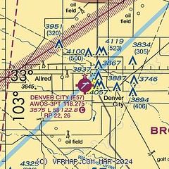
| Sectional chart |
|---|
|
| Airport distance calculator |
|---|
|
|
| Sunrise and sunset |
|---|
|
Times for 12-Apr-2026
| | Local
(UTC-5) | | Zulu
(UTC) |
|---|
| Morning civil twilight | | 07:01 | | 12:01 |
| Sunrise | | 07:26 | | 12:26 |
| Sunset | | 20:18 | | 01:18 |
| Evening civil twilight | | 20:44 | | 01:44 |
|
| Current date and time |
|---|
| Zulu (UTC) | 12-Apr-2026 21:51:37 |
|---|
| Local (UTC-5) | 12-Apr-2026 16:51:37 |
|---|
|
| METAR |
|---|
KGNC
20nm SE | 122135Z AUTO 22014G20KT 10SM SCT110 29/02 A2998 RMK AO2 T02900019
|
KHOB
26nm SW | 122050Z 24014G25KT 10SM SCT100 BKN120 27/01 A2998
|
|
| TAF |
|---|
KHOB
26nm SW | 121720Z 1218/1318 22015G22KT P6SM SCT200 FM130100 21008KT P6SM SCT250
|
|
| NOTAMs |
|---|
NOTAMs are issued by the DoD/FAA and will open in a separate window not controlled by AirNav.
|
|


