FAA INFORMATION EFFECTIVE 14 MAY 2026
Location
| FAA Identifier: | F44 |
| Lat/Long: | 32-09-49.8520N 095-49-42.0710W
32-09.830867N 095-49.701183W
32.1638478,-95.8283531
(estimated) |
| Elevation: | 444.1 ft. / 135.4 m (surveyed) |
| Variation: | 02E (2020) |
| From city: | 3 miles SE of ATHENS, TX |
| Time zone: | UTC -5 (UTC -6 during Standard Time) |
| Zip code: | 75751 |
Airport Operations
| Airport use: | Open to the public |
| Activation date: | 02/1958 |
| Control tower: | no |
| ARTCC: | FORT WORTH CENTER |
| FSS: | FORT WORTH FLIGHT SERVICE STATION |
| NOTAMs facility: | FTW (NOTAM-D service available) |
| Attendance: | 0800-DUSK |
| Wind indicator: | lighted |
| Segmented circle: | yes |
| Lights: | SS-SR |
| Beacon: | white-green (lighted land airport)
Operates sunset to sunrise. |
Airport Communications
| CTAF/UNICOM: | 123.0 |
| WX AWOS-3PT: | 119.6 (903-670-1247) |
- APCH/DEP SVC PRVDD BY FORT WORTH ARTCC (ZFW) ON FREQS 135.25/279.65 (TYLER RCAG).
Nearby radio navigation aids
| VOR radial/distance | | VOR name | | Freq | | Var |
|---|
| FZTr283/16.0 | | FRANKSTON VOR/DME | | 111.40 | | 06E |
| CQYr088/19.8 | | CEDAR CREEK VORTAC | | 114.80 | | 06E |
| TYRr236/24.4 | | TYLER VOR/DME | | 114.20 | | 06E |
| NDB name | | Hdg/Dist | | Freq | | Var | | ID |
|---|
| CROSSROADS | | 045/8.9 | | 215 | | 02E | | CSZ | -.-. ... --.. |
| PYRAMID | | 040/26.1 | | 418 | | 06E | | PYF | .--. -.-- ..-. |
Airport Services
| Fuel available: | 100LL JET-A |
| Parking: | hangars and tiedowns |
| Airframe service: | MAJOR |
| Powerplant service: | MAJOR |
| Bottled oxygen: | HIGH/LOW |
| Bulk oxygen: | NONE |
Runway Information
Runway 18/36
| Dimensions: | 3988 x 60 ft. / 1216 x 18 m |
| Surface: | asphalt, in good condition |
| Weight bearing capacity: | |
| Runway edge lights: | medium intensity |
| RUNWAY 18 | | RUNWAY 36 |
| Latitude: | 32-10.160480N | | 32-09.502748N |
| Longitude: | 095-49.702743W | | 095-49.700232W |
| Elevation: | 438.3 ft. | | 436.9 ft. |
| Traffic pattern: | left | | right |
| Runway heading: | 178 magnetic, 180 true | | 358 magnetic, 360 true |
| Markings: | nonprecision, in fair condition | | nonprecision, in fair condition |
| Visual slope indicator: | 2-light PAPI on left (3.00 degrees glide path) | | 2-light PAPI on left (4.00 degrees glide path) |
| Touchdown point: | yes, no lights | | yes, no lights |
| Obstructions: | 66 ft. trees, 985 ft. from runway, 160 ft. left of centerline, 11:1 slope to clear
11 FT ROAD 160 FT DSTC, 235 FT L. | | 55 ft. trees, 700 ft. from runway, 305 ft. left and right of centerline, 9:1 slope to clear
12-25 FT TREES ON FENCELINE 0-200 FT DSTC, 247 R. |
Airport Ownership and Management from official FAA records
| Ownership: | Publicly-owned |
| Owner: | CITY OF ATHENS
508 E. TYLER
ATHENS, TX 75751
Phone 903-675-5131 |
| Manager: | SHANNON EASLEY
508 E. TYLER
ATHENS, TX 75751
Phone 903-675-8036
PUBLIC WORKS DIRECTOR. |
Additional Remarks
| - | FERAL HOGS ON AND INVOF ARPT. |
| - | FOR CD CTC FORT WORTH ARTCC AT 817-858-7584. |
Instrument Procedures
NOTE: All procedures below are presented as PDF files. If you need a reader for these files, you should download the free Adobe Reader.NOT FOR NAVIGATION. Please procure official charts for flight.
FAA instrument procedures published for use from 14 May 2026 at 0901Z to 11 June 2026 at 0900Z.
IAPs - Instrument Approach Procedures |
|---|
| RNAV (GPS) RWY 18 | |
download (199KB) |
| RNAV (GPS) RWY 36 | |
download (194KB) |
| NOTE: Special Alternate Minimums apply | |
download (37KB) |
| NOTE: Special Take-Off Minimums/Departure Procedures apply | |
download (297KB) |
Other nearby airports with instrument procedures:
KPSN - Palestine Municipal Airport (24 nm S)
KTYR - Tyler Pounds Regional Airport (24 nm NE)
KCRS - C David Campbell Field-Corsicana Municipal Airport (30 nm W)
KJSO - Cherokee County Airport (36 nm SE)
KJDD - Wood County Airport/Collins Field (39 nm NE)
|
|

Road maps at:
MapQuest
Bing
Google
| Aerial photo |
|---|
WARNING: Photo may not be current or correct

Do you have a better or more recent aerial photo of Athens Municipal Airport that you would like to share? If so, please send us your photo.
|
| Sectional chart |
|---|
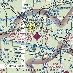
|
CAUTION: Diagram may not be current

| Airport distance calculator |
|---|
|
|
| Sunrise and sunset |
|---|
|
Times for 06-Jun-2026
| | Local
(UTC-5) | | Zulu
(UTC) |
|---|
| Morning civil twilight | | 05:49 | | 10:49 |
| Sunrise | | 06:18 | | 11:18 |
| Sunset | | 20:26 | | 01:26 |
| Evening civil twilight | | 20:54 | | 01:54 |
|
| Current date and time |
|---|
| Zulu (UTC) | 06-Jun-2026 17:13:25 |
|---|
| Local (UTC-5) | 06-Jun-2026 12:13:25 |
|---|
|
| METAR |
|---|
| KF44 | 061655Z AUTO 00000KT 10SM OVC013 25/21 A2989 RMK AO2
|
|
| TAF |
|---|
KTYR
25nm NE | 061333Z 0614/0712 14004KT P6SM VCSH BKN010 OVC150 FM061600 17007KT P6SM VCTS BKN015CB OVC080 TEMPO 0616/0620 3SM TSRA BR BKN015CB OVC050 FM070300 15006KT P6SM BKN025 FM070800 18008KT P6SM OVC012 AMD NOT SKED
|
|
| NOTAMs |
|---|
NOTAMs are issued by the DoD/FAA and will open in a separate window not controlled by AirNav.
|
|


