FAA INFORMATION EFFECTIVE 09 JULY 2026
Location
| FAA Identifier: | PSN |
| Lat/Long: | 31-46-46.9000N 095-42-22.7000W
31-46.781667N 095-42.378333W
31.7796944,-95.7063056
(estimated) |
| Elevation: | 422.6 ft. / 128.8 m (surveyed) |
| Variation: | 04E (2005) |
| From city: | 4 miles NW of PALESTINE, TX |
| Time zone: | UTC -5 (UTC -6 during Standard Time) |
| Zip code: | 75801 |
Airport Operations
| Airport use: | Open to the public |
| Activation date: | 11/1942 |
| Control tower: | no |
| ARTCC: | FORT WORTH CENTER |
| FSS: | FORT WORTH FLIGHT SERVICE STATION |
| NOTAMs facility: | PSN (NOTAM-D service available) |
| Attendance: | 0800-1700
FOR SVC AFT HRS CALL 903-724-2225. CALL-IN FEE. |
| Wind indicator: | lighted |
| Segmented circle: | yes |
| Lights: | MIRL RWY 18/36 PRESET LOW INTST DUSK-DAWN; TO INCR INTST ACTVT - CTAF. |
| Beacon: | white-green (lighted land airport)
Operates sunset to sunrise. |
Airport Communications
| CTAF/UNICOM: | 122.7 |
| WX AWOS-3PT: | 118.025 (903-729-3641) |
- APCH/DEP SVC PRVDD BY FORT WORTH ARTCC (ZFW) ON FREQS 135.25/279.65 (TYLER RCAG).
Nearby radio navigation aids
| VOR radial/distance | | VOR name | | Freq | | Var |
|---|
| FZTr201/19.8 | | FRANKSTON VOR/DME | | 111.40 | | 06E |
| CQYr127/35.7 | | CEDAR CREEK VORTAC | | 114.80 | | 06E |
| TYRr198/37.8 | | TYLER VOR/DME | | 114.20 | | 06E |
| NDB name | | Hdg/Dist | | Freq | | Var | | ID |
|---|
| CROSSROADS | | 141/21.3 | | 215 | | 02E | | CSZ | -.-. ... --.. |
| PYRAMID | | 095/25.5 | | 418 | | 06E | | PYF | .--. -.-- ..-. |
Airport Services
| Fuel available: | 100LL JET-A |
| Parking: | hangars and tiedowns |
| Bottled oxygen: | NONE |
| Bulk oxygen: | NONE |
Runway Information
Runway 18/36
| Dimensions: | 5005 x 100 ft. / 1526 x 30 m |
| Surface: | asphalt, in excellent condition |
| Weight bearing capacity: | | Single wheel: | 45.0 | | Double wheel: | 70.0 | | Double tandem: | 135.0 |
|
| Runway edge lights: | medium intensity |
| RUNWAY 18 | | RUNWAY 36 |
| Latitude: | 31-47.322702N | | 31-46.497233N |
| Longitude: | 095-42.375833W | | 095-42.384615W |
| Elevation: | 413.0 ft. | | 409.5 ft. |
| Traffic pattern: | left | | left |
| Runway heading: | 177 magnetic, 181 true | | 357 magnetic, 001 true |
| Markings: | nonprecision, in good condition | | nonprecision, in good condition |
| Visual slope indicator: | 4-light PAPI on left (3.00 degrees glide path) | | 4-light PAPI on left (3.00 degrees glide path) |
| Runway end identifier lights: | | | yes
REIL OTS INDEFLY. |
| Touchdown point: | yes, no lights | | yes, no lights |
| Obstructions: | 50 ft. tree, 750 ft. from runway, 276 ft. right of centerline, 11:1 slope to clear | | 32 ft. trees, 672 ft. from runway, 155 ft. right of centerline, 14:1 slope to clear
10 BRUSH 90 FT DSTC, 245 R. |
Runway 9/27
| Dimensions: | 4002 x 75 ft. / 1220 x 23 m |
| Surface: | asphalt, in fair condition |
| Weight bearing capacity: | | Single wheel: | 45.0 | | Double wheel: | 70.0 | | Double tandem: | 135.0 |
|
| Runway edge lights: | medium intensity |
| RUNWAY 9 | | RUNWAY 27 |
| Latitude: | 31-46.624400N | | 31-46.618032N |
| Longitude: | 095-42.762512W | | 095-41.989840W |
| Elevation: | 422.5 ft. | | 387.8 ft. |
| Traffic pattern: | left | | left |
| Runway heading: | 087 magnetic, 091 true | | 267 magnetic, 271 true |
| Markings: | nonprecision, in fair condition | | nonprecision, in fair condition |
| Touchdown point: | yes, no lights | | yes, no lights |
| Obstructions: | 56 ft. trees, 856 ft. from runway, 11:1 slope to clear
15 FT BRUSH 160 FT DSTC, 234 R. | | 35 ft. trees, 201 ft. from runway, 200 ft. left and right of centerline, 1:1 slope to clear
25 FT TREES 120-200 FT DSTC, 249 FT L/R |
Airport Ownership and Management from official FAA records
| Ownership: | Publicly-owned |
| Owner: | CITY OF PALESTINE
504 N QUEEN
PALESTINE, TX 75801
Phone 903-731-8423 |
| Manager: | TERESA HERRERA
504 N. QUEEN
PALESTINE, TX 75801
Phone 903-731-8415
CITY/ARPT MGR |
Additional Remarks
| - | FOR CD CTC FORT WORTH ARTCC AT 817-858-7584. |
| - | RWY 09/27 CLSD DAILY SS-SR, PERM. |
Instrument Procedures
NOTE: All procedures below are presented as PDF files. If you need a reader for these files, you should download the free Adobe Reader.NOT FOR NAVIGATION. Please procure official charts for flight.
FAA instrument procedures published for use from 09 July 2026 at 0901Z to 06 August 2026 at 0900Z.
IAPs - Instrument Approach Procedures |
|---|
| RNAV (GPS) RWY 18 | |
download (216KB) |
| RNAV (GPS) RWY 36 | |
download (213KB) |
| NOTE: Special Alternate Minimums apply | |
download (125KB) |
| NOTE: Special Take-Off Minimums/Departure Procedures apply | |
download (229KB) |
Other nearby airports with instrument procedures:
F44 - Athens Municipal Airport (24 nm N)
KJSO - Cherokee County Airport (25 nm E)
KDKR - Houston County Airport (32 nm SE)
KTYR - Tyler Pounds Regional Airport (38 nm NE)
KCRS - C David Campbell Field-Corsicana Municipal Airport (38 nm NW)
|
|

Road maps at:
MapQuest
Bing
Google
| Aerial photo |
|---|
WARNING: Photo may not be current or correct
 Photo by Mike Buoy
Taken in August 2012
looking north.
Photo by Mike Buoy
Taken in August 2012
looking north.
Do you have a better or more recent aerial photo of Palestine Municipal Airport that you would like to share? If so, please send us your photo.
|
| Sectional chart |
|---|
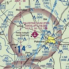
|
| Airport distance calculator |
|---|
|
|
| Sunrise and sunset |
|---|
|
Times for 13-Jul-2026
| | Local
(UTC-5) | | Zulu
(UTC) |
|---|
| Morning civil twilight | | 06:00 | | 11:00 |
| Sunrise | | 06:28 | | 11:28 |
| Sunset | | 20:29 | | 01:29 |
| Evening civil twilight | | 20:57 | | 01:57 |
|
| Current date and time |
|---|
| Zulu (UTC) | 13-Jul-2026 23:31:38 |
|---|
| Local (UTC-5) | 13-Jul-2026 18:31:38 |
|---|
|
| METAR |
|---|
| KPSN | 132315Z AUTO 12007KT 10SM BKN016 28/24 A3007 RMK AO2
|
|
| TAF |
|---|
KTYR
39nm NE | 131935Z 1320/1418 02003KT P6SM BKN007 BKN030 BKN100 TEMPO 1320/1321 SCT004 OVC030 FM132100 VRB06KT P6SM VCSH BKN035 BKN200 FM140600 VRB03KT P6SM BKN040 BKN150 BKN250 FM141200 00000KT 2SM BR BKN007 FM141500 31003KT P6SM BKN015
|
|
| NOTAMs |
|---|
NOTAMs are issued by the DoD/FAA and will open in a separate window not controlled by AirNav.
|
|

