FAA INFORMATION EFFECTIVE 11 JUNE 2026
Location
| FAA Identifier: | F85 |
| Lat/Long: | 33-43-52.8008N 102-44-06.2928W
33-43.880013N 102-44.104880W
33.7313336,-102.7350813
(estimated) |
| Elevation: | 3747.2 ft. / 1142.1 m (surveyed) |
| Variation: | 09E (1985) |
| From city: | 2 miles E of MORTON, TX |
| Time zone: | UTC -5 (UTC -6 during Standard Time) |
| Zip code: | 79346 |
Airport Operations
| Airport use: | Open to the public |
| Activation date: | 02/1970 |
| Control tower: | no |
| ARTCC: | FORT WORTH CENTER |
| FSS: | FORT WORTH FLIGHT SERVICE STATION |
| NOTAMs facility: | FTW (NOTAM-D service available) |
| Attendance: | UNATNDD |
| Wind indicator: | lighted |
| Segmented circle: | yes |
| Lights: | SS-SR |
| Beacon: | white-green (lighted land airport)
Operates sunset to sunrise. |
Airport Communications
Airport Services
| Parking: | tiedowns |
| Bottled oxygen: | NONE |
| Bulk oxygen: | NONE |
Runway Information
Runway 4/22
| Dimensions: | 2710 x 60 ft. / 826 x 18 m |
| Surface: | asphalt, in fair condition |
| Weight bearing capacity: | |
| Runway edge lights: | medium intensity |
| RUNWAY 4 | | RUNWAY 22 |
| Latitude: | 33-43.739500N | | 33-44.026000N |
| Longitude: | 102-44.404667W | | 102-43.994333W |
| Elevation: | 3743.3 ft. | | 3747.2 ft. |
| Traffic pattern: | left | | left |
| Runway heading: | 041 magnetic, 050 true | | 221 magnetic, 230 true |
| Displaced threshold: | 160 ft. | | no |
| Markings: | basic, in fair condition | | basic, in fair condition |
| Visual slope indicator: | | | 2-box VASI on left (3.00 degrees glide path) |
| Obstructions: | 15 ft. road, 201 ft. from runway, 60 ft. left of centerline
15 FT RD, 116 FT DSTC, 135 FT L. | | 15 ft. road, 420 ft. from runway, 14:1 slope to clear |
Runway 17/35
| Dimensions: | 1775 x 39 ft. / 541 x 12 m |
| Surface: | asphalt, in poor condition
EXTSV CRACKING, VEGETATION GROWING THROUGH. |
| Weight bearing capacity: | |
| Operational restrictions: | RWY CLSD NGT. |
| RUNWAY 17 | | RUNWAY 35 |
| Latitude: | 33-44.022167N | | 33-43.729500N |
| Longitude: | 102-43.957667W | | 102-43.963167W |
| Elevation: | 3746.7 ft. | | 3740.2 ft. |
| Traffic pattern: | left | | left |
| Runway heading: | 172 magnetic, 181 true | | 352 magnetic, 001 true |
| Markings: | basic, in good condition | | basic, in good condition |
| Obstructions: | none | | 15 ft. road, 300 ft. from runway, 6:1 slope to clear |
Airport Ownership and Management from official FAA records
| Ownership: | Publicly-owned |
| Owner: | COCHRAN COUNTY
COCHRAN CO COURTHOUSE, 101 MAIN ST
MORTON, TX 79346
Phone 806-266-5508 |
| Manager: | PAT HENRY
COCHRAN CO COURTHOUSE ROOM 105
101 MAIN ST, TX 79346
Phone 806-266-5508
COUNTY JUDGE. EMERG CTC 806-266-5700. |
Additional Remarks
| - | 4171 FT MSL, 399 FT AGL TWR, 1.5 NM SW. |
| - | FOR CD CTC FORT WORTH ARTCC AT 817-858-7584. |
| - | RWY 4/22 MIRL OTS INDFLY. |
Instrument Procedures
There are no published instrument procedures at F85.
Some nearby airports with instrument procedures:
KLIU - Littlefield Taylor Brown Municipal Airport (21 nm NE)
KLLN - Levelland Municipal Airport (21 nm SE)
2T1 - Muleshoe Municipal Airport (28 nm N)
F98 - Yoakum County Airport (31 nm S)
KPRZ - Portales Municipal Airport (42 nm NW)
|
|

Road maps at:
MapQuest
Bing
Google
| Aerial photo |
|---|

|
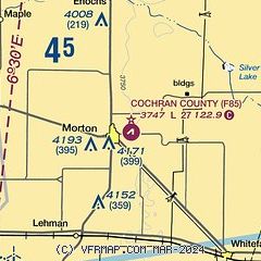
| Sectional chart |
|---|
|
| Airport distance calculator |
|---|
|
|
| Sunrise and sunset |
|---|
|
Times for 11-Jun-2026
| | Local
(UTC-5) | | Zulu
(UTC) |
|---|
| Morning civil twilight | | 06:12 | | 11:12 |
| Sunrise | | 06:41 | | 11:41 |
| Sunset | | 21:00 | | 02:00 |
| Evening civil twilight | | 21:29 | | 02:29 |
|
| Current date and time |
|---|
| Zulu (UTC) | 12-Jun-2026 00:30:49 |
|---|
| Local (UTC-5) | 11-Jun-2026 19:30:49 |
|---|
|
| METAR |
|---|
KLLN
21nm SE | 120015Z AUTO 03023G33KT 6SM VCTS RA HZ FEW037 SCT055 BKN075 27/18 A2988 RMK AO2
|
|
| TAF |
|---|
KLBB
46nm E | 111720Z 1118/1218 22011KT P6SM SCT250 FM112200 VRB15KT P6SM VCTS BKN100CB FM120200 07015G25KT P6SM BKN100 FM121300 08011KT P6SM BKN020
|
KCVS
48nm NW | 111800Z 1118/1224 02015G25KT 9999 FEW300 520009 QNH2985INS BECMG 1119/1120 05020G30KT 9999 FEW300 520009 QNH2989INS BECMG 1205/1206 09015G25KT 9999 FEW015 520009 QNH2996INS BECMG 1210/1211 08012G22KT 9999 BKN015 QNH2999INS BECMG 1215/1216 17010G20KT 9999 FEW080 QNH3004INS BECMG 1223/1224 16015G25KT 9999 VCTS BKN080CB QNH2999INS TX38/1121Z TN19/1212Z
|
|
| NOTAMs |
|---|
NOTAMs are issued by the DoD/FAA and will open in a separate window not controlled by AirNav.
|
|


