FAA INFORMATION EFFECTIVE 09 JULY 2026
Location
| FAA Identifier: | LLN |
| Lat/Long: | 33-33-09.1000N 102-22-21.1000W
33-33.151667N 102-22.351667W
33.5525278,-102.3725278
(estimated) |
| Elevation: | 3514.1 ft. / 1071.1 m (surveyed) |
| Variation: | 09E (1995) |
| From city: | 2 miles S of LEVELLAND, TX |
| Time zone: | UTC -5 (UTC -6 during Standard Time) |
| Zip code: | 79336 |
Airport Operations
| Airport use: | Open to the public |
| Activation date: | 05/1945 |
| Control tower: | no |
| ARTCC: | FORT WORTH CENTER |
| FSS: | FORT WORTH FLIGHT SERVICE STATION |
| NOTAMs facility: | FTW (NOTAM-D service available) |
| Attendance: | MON-FRI 0800-1600 |
| Wind indicator: | lighted |
| Segmented circle: | yes |
| Lights: | MIRL RWY 17/35 PRESET LOW INTST; TO INCR INTST ACTVT - CTAF. |
| Beacon: | white-green (lighted land airport)
Operates sunset to sunrise. |
Airport Communications
| CTAF/UNICOM: | 122.8 |
| WX AWOS-3PT: | 121.125 (806-897-4770) |
| LUBBOCK APPROACH: | 119.2 119.9 |
| LUBBOCK DEPARTURE: | 119.2 119.9 |
Nearby radio navigation aids
| VOR radial/distance | | VOR name | | Freq | | Var |
|---|
| LBBr237/24.7 | | LUBBOCK VORTAC | | 109.20 | | 11E |
Airport Services
| Fuel available: | 100LL JET-A
100LL:FUEL SELF-SVC. |
| Parking: | tiedowns |
| Airframe service: | MAJOR |
| Powerplant service: | MAJOR |
Runway Information
Runway 17/35
| Dimensions: | 6110 x 75 ft. / 1862 x 23 m |
| Surface: | asphalt, in good condition |
| Weight bearing capacity: | |
| Runway edge lights: | medium intensity |
| RUNWAY 17 | | RUNWAY 35 |
| Latitude: | 33-33.491920N | | 33-32.485095N |
| Longitude: | 102-22.347720W | | 102-22.380337W |
| Elevation: | 3504.7 ft. | | 3509.7 ft. |
| Traffic pattern: | left | | right |
| Runway heading: | 173 magnetic, 182 true | | 353 magnetic, 002 true |
| Markings: | nonprecision, in good condition | | nonprecision, in good condition |
| Visual slope indicator: | 4-light PAPI on left (3.00 degrees glide path) | | 4-light PAPI on left (3.00 degrees glide path) |
| Runway end identifier lights: | | | yes |
| Touchdown point: | yes, no lights | | yes, no lights |
| Obstructions: | 48 ft. tree, 1345 ft. from runway, 285 ft. left of centerline, 23:1 slope to clear | | none |
Runway 8/26
| Dimensions: | 2072 x 55 ft. / 632 x 17 m |
| Surface: | asphalt, in good condition |
| RUNWAY 8 | | RUNWAY 26 |
| Latitude: | 33-33.640545N | | 33-33.631070N |
| Longitude: | 102-22.519508W | | 102-22.112032W |
| Elevation: | 3509.5 ft. | | 3504.3 ft. |
| Traffic pattern: | right | | left |
| Runway heading: | 083 magnetic, 092 true | | 263 magnetic, 272 true |
| Touchdown point: | yes, no lights | | yes, no lights |
| Obstructions: | 15 ft. road, 604 ft. from runway, 165 ft. left and right of centerline, 26:1 slope to clear
PRIVATE RD. | | 10 ft. road, 202 ft. from runway, 127 ft. left and right of centerline
4 FT FENCE, 185 FT DSTC, 125 FT L/R. |
Airport Ownership and Management from official FAA records
| Ownership: | Publicly-owned |
| Owner: | LEVELLAND CITY & HOCKLEY CO
PO BOX 1010
LEVELLAND, TX 79336
Phone 806-470-8768 |
| Manager: | RICHARD HARVEY
P.O. BOX 1624
LEVELLAND, TX 79336
Phone 806-470-8768 |
Additional Remarks
| - | FOR CD CTC FORT WORTH ARTCC AT 817-858-7584. |
| - | ACFT NOT VISIBLE FROM OPPOSITE RWY END. |
Instrument Procedures
NOTE: All procedures below are presented as PDF files. If you need a reader for these files, you should download the free Adobe Reader.NOT FOR NAVIGATION. Please procure official charts for flight.
FAA instrument procedures published for use from 09 July 2026 at 0901Z to 06 August 2026 at 0900Z.
IAPs - Instrument Approach Procedures |
|---|
| RNAV (GPS) RWY 17 | |
download (211KB) |
| RNAV (GPS) RWY 35 | |
download (199KB) |
| NOTE: Special Take-Off Minimums/Departure Procedures apply | |
download (297KB) |
Other nearby airports with instrument procedures:
KLIU - Littlefield Taylor Brown Municipal Airport (22 nm N)
KBFE - Terry County Airport (24 nm S)
F82 - Lubbock Executive Airpark (28 nm E)
KLBB - Lubbock Preston Smith International Airport (28 nm E)
F98 - Yoakum County Airport (31 nm SW)
|
|

Road maps at:
MapQuest
Bing
Google
| Aerial photo |
|---|
WARNING: Photo may not be current or correct
 Photo taken 23-Sep-2009
Do you have a better or more recent aerial photo of Levelland Municipal Airport that you would like to share? If so, please send us your photo.
|
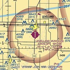
| Sectional chart |
|---|
|
| Airport distance calculator |
|---|
|
|
| Sunrise and sunset |
|---|
|
Times for 28-Jul-2026
| | Local
(UTC-5) | | Zulu
(UTC) |
|---|
| Morning civil twilight | | 06:33 | | 11:33 |
| Sunrise | | 07:00 | | 12:00 |
| Sunset | | 20:52 | | 01:52 |
| Evening civil twilight | | 21:19 | | 02:19 |
|
| Current date and time |
|---|
| Zulu (UTC) | 28-Jul-2026 15:22:01 |
|---|
| Local (UTC-5) | 28-Jul-2026 10:22:01 |
|---|
|
| METAR |
|---|
| KLLN | 281455Z AUTO 15007KT 9SM CLR 27/15 A3003 RMK AO2
|
|
| TAF |
|---|
KLBB
29nm E | 281120Z 2812/2912 20010KT P6SM FEW120 FM290000 16014KT P6SM FEW250
|
|
| NOTAMs |
|---|
NOTAMs are issued by the DoD/FAA and will open in a separate window not controlled by AirNav.
|
|


