FAA INFORMATION EFFECTIVE 27 NOVEMBER 2025
Location
| FAA Identifier: | GRI |
| Lat/Long: | 40-58-03.1530N 098-18-34.7000W
40-58.052550N 098-18.578333W
40.9675425,-98.3096389
(estimated) |
| Elevation: | 1847.1 ft. / 563 m (estimated) |
| Variation: | 07E (1995) |
| From city: | 3 miles NE of GRAND ISLAND, NE |
| Time zone: | UTC -6 (UTC -5 during Daylight Saving Time) |
| Zip code: | 68801 |
Airport Operations
| Airport use: | Open to the public |
| Activation date: | 04/1940 |
| Control tower: | yes |
| ARTCC: | MINNEAPOLIS CENTER |
| FSS: | COLUMBUS FLIGHT SERVICE STATION |
| NOTAMs facility: | GRI (NOTAM-D service available) |
| Attendance: | CONTINUOUS |
| Wind indicator: | lighted |
| Segmented circle: | no |
| Lights: | ACTVT PAPI RWY 31 & 35 - CTAF. WHEN TWR CLSD ACTVT MALS RWY 13 & 17; MALSR RWY 35; REIL RWY 31; PAPI RWY 13 & 17; MIRL RWY 13/31; HIRL RWY 17/35 - CTAF. |
| Beacon: | white-green (lighted land airport)
Operates sunset to sunrise. |
| Fire and rescue: | ARFF index B |
| Airline operations: | PPR 24 HRS FOR UNSKED ACR OPNS WITH MORE THAN 30 PSGR SEATS CALL AMGR (308) 385-5170. INDEX C LEVEL ARFF IS AVBL UPON REQUEST. ACR OPNS OVER 9 PSGR SEATS NOT AUTHORIZED IN EXCESS OF 15 MINS BEFORE OR AFT SKED ARR/DEP TIMES EXCEPT WITH PRIOR COORDINATION WITH AMGR. |
Airport Communications
| CTAF: | 118.2 |
| UNICOM: | 122.95 |
| ATIS: | 127.4 |
| WX ASOS: | PHONE 308-314-0825 |
| GRAND ISLAND GROUND: | 121.9 259.3 [0700-2000] |
| GRAND ISLAND TOWER: | 118.2 259.3 [0700-2000] |
| CLEARANCE DELIVERY: | 121.9 |
| ARNG OPS: | 140.5 242.4 38.3 |
| WX AWOS-3 at AUH (15 nm E): | 121.225 (402-694-5472) |
- APCH/DEP SVC PRVDD BY MINNEAPOLIS ARTCC ON FREQS 119.4/278.8 (HASTINGS RCAG).
- CLEARANCE DELIVERY PRVDD BY MINNEAPOLIS ARTCC ON FREQ 126.05 (GRAND ISLAND RCAG) WHEN GRI ATCT CLSD.
Nearby radio navigation aids
| VOR radial/distance | | VOR name | | Freq | | Var |
|---|
| GRIr160/1.0 | | GRAND ISLAND VOR/DME | | 116.55 | | 07E |
| EARr060/(34.7) | | KEARNEY VOR | | 111.20 | | 05E |
| NDB name | | Hdg/Dist | | Freq | | Var | | ID |
|---|
| YORK | | 272/31.7 | | 257 | | 06E | | JYR | .--- -.-- .-. |
Airport Services
| Fuel available: | 100LL JET-A |
| Parking: | hangars and tiedowns |
| Airframe service: | MAJOR |
| Powerplant service: | MAJOR |
| Bottled oxygen: | NONE |
| Bulk oxygen: | HIGH/LOW |
Runway Information
Runway 17/35
| Dimensions: | 7002 x 150 ft. / 2134 x 46 m |
| Surface: | concrete/grooved, in excellent condition |
| Weight bearing capacity: | | PCN 35 /R/B/W/U | | Single wheel: | 75.0 | | Double wheel: | 110.0 | | Double tandem: | 185.0 |
|
| Runway edge lights: | high intensity |
| RUNWAY 17 | | RUNWAY 35 |
| Latitude: | 40-58.630450N | | 40-57.477467N |
| Longitude: | 098-18.886283W | | 098-18.894283W |
| Elevation: | 1843.7 ft. | | 1846.7 ft. |
| Traffic pattern: | left | | left |
| Runway heading: | 173 magnetic, 180 true | | 353 magnetic, 000 true |
| Declared distances: | TORA:7002 TODA:7002 ASDA:7002 LDA:7002 | | TORA:7002 TODA:7002 ASDA:7002 LDA:7002 |
| Markings: | nonprecision, in good condition | | precision, in good condition |
| Visual slope indicator: | 4-light PAPI on left (3.00 degrees glide path) | | 4-light PAPI on left (2.60 degrees glide path)
PAPI RESTRICTED BYD 6 DEG RIGHT OF CNTRL. |
| RVR equipment: | rollout | | touchdown |
| Approach lights: | MALS: 1,400 foot medium intensity approach lighting system | | MALSR: 1,400 foot medium intensity approach lighting system with runway alignment indicator lights |
| Touchdown point: | yes, no lights | | yes, no lights |
| Instrument approach: | | | ILS |
Runway 13/31
| Dimensions: | 6608 x 100 ft. / 2014 x 30 m |
| Surface: | concrete, in excellent condition |
| Weight bearing capacity: | | PCN 15 /R/C/W/T | | Single wheel: | 45.0 | | Double wheel: | 59.0 |
|
| Runway edge lights: | medium intensity |
| RUNWAY 13 | | RUNWAY 31 |
| Latitude: | 40-58.702000N | | 40-57.928333N |
| Longitude: | 098-18.703167W | | 098-17.693500W |
| Elevation: | 1840.0 ft. | | 1843.0 ft. |
| Traffic pattern: | left | | left |
| Runway heading: | 128 magnetic, 135 true | | 308 magnetic, 315 true |
| Declared distances: | TORA:6608 TODA:6608 ASDA:6608 LDA:6608 | | TORA:6608 TODA:6608 ASDA:6608 LDA:6608 |
| Markings: | nonprecision, in good condition | | nonprecision, in good condition |
| Visual slope indicator: | 4-light PAPI on left (3.00 degrees glide path) | | 4-light PAPI on left (3.00 degrees glide path) |
| Approach lights: | MALS: 1,400 foot medium intensity approach lighting system | | |
| Runway end identifier lights: | | | yes |
| Touchdown point: | yes, no lights | | yes, no lights |
Airport Ownership and Management from official FAA records
| Ownership: | Publicly-owned |
| Owner: | HALL COUNTY ARPT AUTH
3579 SKY PARK ROAD
GRAND ISLAND, NE 68801
Phone 308-385-5170 |
| Manager: | MR. MICHAEL OLSON, A.A.E.
3855 SKY PARK ROAD
GRAND ISLAND, NE 68801
Phone 308-385-5170
OR 308-385-5172. |
Additional Remarks
| - | COMPRESSED NITROGEN FOR STRUT INFLATION AVBL. |
| - | INBOUND ACFT CTC OPS 10 MIN PRIOR TO LNDG. |
| - | ARNG: OPR 0730-1600++MON-FRI; OCNL WKEND. PPR TO PRK ARNG RAMP. DSN 279-8691, C402-309-8691. |
| - | MIGRATORY WATERFOWL ON & INVOF ARPT. |
| - | TWY DELTA EXIT OFF RY 17/35 CLSD TO LARGE ACFT DUE TO INADEQUATE TURNING RADIUS. |
Instrument Procedures
NOTE: All procedures below are presented as PDF files. If you need a reader for these files, you should download the free Adobe Reader.NOT FOR NAVIGATION. Please procure official charts for flight.
FAA instrument procedures published for use from 27 November 2025 at 0901Z to 25 December 2025 at 0900Z.
IAPs - Instrument Approach Procedures |
|---|
| ILS OR LOC RWY 35 **CHANGED** | |
download (244KB) |
| RNAV (GPS) RWY 13 **CHANGED** | |
download (207KB) |
| RNAV (GPS) RWY 17 **CHANGED** | |
download (251KB) |
| RNAV (GPS) RWY 31 **CHANGED** | |
download (204KB) |
| RNAV (GPS) RWY 35 **CHANGED** | |
download (277KB) |
| LOC/DME BC RWY 17 **CHANGED** | |
download (209KB) |
| VOR/DME RWY 31 **CHANGED** | |
download (193KB) |
| VOR/DME RWY 35 **CHANGED** | |
download (209KB) |
| VOR RWY 13 **CHANGED** | |
download (190KB) |
| VOR RWY 17 **CHANGED** | |
download (182KB) |
| NOTE: Special Alternate Minimums apply | |
download (140KB) |
| NOTE: Special Take-Off Minimums/Departure Procedures apply | |
download (147KB) |
Other nearby airports with instrument procedures:
07K - Central City Municipal Airport/Larry Reineke Field (15 nm NE)
KAUH - Aurora Municipal Airport/Al Potter Field (15 nm E)
08K - Harvard State Airport (22 nm SE)
KHSI - Hastings Municipal Airport (22 nm S)
KJYR - York Municipal Airport (31 nm E)
|
|

Road maps at:
MapQuest
Bing
Google
| Aerial photo |
|---|
WARNING: Photo may not be current or correct

Do you have a better or more recent aerial photo of Central Nebraska Regional Airport that you would like to share? If so, please send us your photo.
|
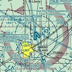
| Sectional chart |
|---|
|
 Download PDF
of official airport diagram from the FAA
| Airport distance calculator |
|---|
|
|
| Sunrise and sunset |
|---|
|
Times for 07-Dec-2025
| | Local
(UTC-6) | | Zulu
(UTC) |
|---|
| Morning civil twilight | | 07:15 | | 13:15 |
| Sunrise | | 07:46 | | 13:46 |
| Sunset | | 17:04 | | 23:04 |
| Evening civil twilight | | 17:35 | | 23:35 |
|
| Current date and time |
|---|
| Zulu (UTC) | 07-Dec-2025 11:34:20 |
|---|
| Local (UTC-6) | 07-Dec-2025 05:34:20 |
|---|
|
| METAR |
|---|
| KGRI | 071053Z AUTO 02009KT 10SM OVC008 M03/M05 A3014 RMK AO2 CIG 005V010 SLP225 T10331050 $
|
KAUH
15nm E | 071115Z AUTO 01009KT 10SM OVC005 M03/M03 A3013 RMK AO2 T10301035
|
|
| TAF |
|---|
| KGRI | 070904Z 0709/0806 01012KT P6SM OVC012 TEMPO 0709/0712 OVC009 FM071400 02008KT P6SM OVC015 FM071700 03005KT P6SM BKN025 OVC100 PROB30 0719/0724 6SM -SN OVC020 FM080100 VRB05KT P6SM SCT040
|
|
| NOTAMs |
|---|
NOTAMs are issued by the DoD/FAA and will open in a separate window not controlled by AirNav.
|
|


