FAA INFORMATION EFFECTIVE 12 JUNE 2025
Location
| FAA Identifier: | HPN |
| Lat/Long: | 41-04-01.0310N 073-42-27.2380W
41-04.017183N 073-42.453967W
41.0669531,-73.7075661
(estimated) |
| Elevation: | 439 ft. / 133.8 m (surveyed) |
| Variation: | 13W (2020) |
| From city: | 3 miles NE of WHITE PLAINS, NY |
| Time zone: | UTC -4 (UTC -5 during Standard Time) |
| Zip code: | 10604 |
Airport Operations
| Airport use: | Open to the public |
| Activation date: | 11/1943 |
| Control tower: | yes |
| ARTCC: | NEW YORK CENTER |
| FSS: | NEW YORK FLIGHT SERVICE STATION |
| NOTAMs facility: | HPN (NOTAM-D service available) |
| Attendance: | CONTINUOUS |
| Wind indicator: | lighted |
| Segmented circle: | no |
| Lights: | WHEN ATCT CLSD ACTVT MALSR RWY 16; REIL RWY 11 & 34; TDZ LGTS RWY 16; CNTRLN LGTS RWY 16/34; HIRL RWY 16/34; MIRL RWY 11/29; TWY LGTS - CTAF. |
| Beacon: | white-green (lighted land airport)
Operates sunset to sunrise. |
| Landing fee: | yes |
| Fire and rescue: | ARFF index B |
| International operations: | customs landing rights airport |
Airport Communications
| CTAF: | 118.575 |
| UNICOM: | 122.95 |
| WX ASOS: | PHONE 914-288-0216 |
| WESTCHESTER GROUND: | 121.825 284.65 [0600-2300] |
| WESTCHESTER TOWER: | 118.575 284.65 [0600-2300] |
| NEW YORK APPROACH: | 120.8 ;2300-0700 126.4 ;0700-2300 124.65 |
| NEW YORK DEPARTURE: | 120.55 |
| CLEARANCE DELIVERY: | 126.4 ;WHEN HPN TWR CLSD 127.25 |
| BOUNO STAR: | 124.075 133.1 |
| D-ATIS: | 133.8 |
| EMERG: | 121.5 243.0 |
| NOBBI STAR: | 120.8 |
| RICED STAR: | 120.8 124.075 125.975 126.4 |
| VALRE STAR: | 120.8 126.4 |
| WX ASOS at LGA (19 nm SW): | PHONE 929-229-1994 |
- (ATIS DESCRIPTION) ATIS CAN ALSO BE RECD AIRBORNE VIA CMK VOR FREQ 116.6 (CARMEL).
Nearby radio navigation aids
| VOR radial/distance | | VOR name | | Freq | | Var |
|---|
| CMKr216/14.0 | | CARMEL VOR/DME | | 116.60 | | 12W |
| LGAr035/18.5 | | LA GUARDIA VOR/DME | | 113.10 | | 12W |
| TEBr062/20.7 | | TETERBORO VOR/DME | | 108.40 | | 11W |
| DPKr324/24.7 | | DEER PARK VOR/DME | | 117.70 | | 12W |
| JFKr018/26.2 | | KENNEDY VOR/DME | | 115.90 | | 12W |
| BDRr270/27.0 | | BRIDGEPORT VOR/DME | | 108.80 | | 12W |
| CRIr028/28.6 | | CANARSIE VOR/DME | | 112.30 | | 11W |
| IGNr184/36.3 | | KINGSTON VOR/DME | | 117.60 | | 12W |
| SAXr101/37.6 | | SPARTA VORTAC | | 115.70 | | 11W |
| NDB name | | Hdg/Dist | | Freq | | Var | | ID |
|---|
| STANWYCK | | 163/31.6 | | 261 | | 12W | | SKU | ... -.- ..- |
Airport Services
| Fuel available: | 100LL JET-A |
| Parking: | hangars and tiedowns |
| Airframe service: | MAJOR |
| Powerplant service: | MAJOR |
| Bottled oxygen: | HIGH/LOW |
| Bulk oxygen: | HIGH/LOW |
Runway Information
Runway 16/34
| Dimensions: | 6549 x 150 ft. / 1996 x 46 m |
| Surface: | asphalt/grooved, in good condition |
| Weight bearing capacity: | |
| Runway edge lights: | high intensity |
| RUNWAY 16 | | RUNWAY 34 |
| Latitude: | 41-04.533187N | | 41-03.600050N |
| Longitude: | 073-42.798335W | | 073-42.084142W |
| Elevation: | 439.0 ft. | | 379.8 ft. |
| Traffic pattern: | left | | left |
| Runway heading: | 163 magnetic, 150 true | | 343 magnetic, 330 true |
| Declared distances: | TORA:6549 TODA:6549 ASDA:6549 LDA:6549 | | TORA:6549 TODA:6549 ASDA:6549 LDA:6549 |
| Markings: | precision, in good condition | | precision, in good condition |
| Visual slope indicator: | 4-light PAPI on left (3.00 degrees glide path) | | 4-light PAPI on left (3.00 degrees glide path) |
| RVR equipment: | touchdown | | rollout |
| Approach lights: | MALSR: 1,400 foot medium intensity approach lighting system with runway alignment indicator lights | | |
| Runway end identifier lights: | | | yes |
| Centerline lights: | yes | | yes |
| Touchdown point: | yes, lighted | | yes, no lights |
| Instrument approach: | ILS/DME | | ILS/DME |
| Obstructions: | none | | 87 ft. bldg, lighted, 3460 ft. from runway, 600 ft. right of centerline, 37:1 slope to clear |
Runway 11/29
| Dimensions: | 4451 x 150 ft. / 1357 x 46 m |
| Surface: | asphalt/grooved, in fair condition |
| Weight bearing capacity: | | PCN 28 /F/B/X/U | | Single wheel: | 70.0 | | Double wheel: | 120.0 | | Double tandem: | 120.0 |
|
| Runway edge lights: | medium intensity |
| Runway edge markings: | RWY 11 AIMING POINT MARKINGS. |
| RUNWAY 11 | | RUNWAY 29 |
| Latitude: | 41-04.023118N | | 41-03.865678N |
| Longitude: | 073-42.945630W | | 073-41.999887W |
| Elevation: | 397.2 ft. | | 387.7 ft. |
| Traffic pattern: | left | | left |
| Runway heading: | 115 magnetic, 102 true | | 295 magnetic, 282 true |
| Displaced threshold: | no | | 1292 ft. |
| Declared distances: | TORA:4451 TODA:4451 ASDA:4451 LDA:4451 | | TORA:4451 TODA:4451 ASDA:4451 LDA:3159 |
| Markings: | basic, in good condition | | basic, in good condition |
| Visual slope indicator: | 4-light PAPI on left (3.00 degrees glide path) | | |
| Runway end identifier lights: | yes | | |
| Touchdown point: | yes, no lights | | yes, no lights |
| Obstructions: | none | | 71 ft. trees, 527 ft. from runway, 15 ft. right of centerline, 4:1 slope to clear
APCH RATIO 25:1 TO DSPLCD THR. |
Airport Ownership and Management from official FAA records
| Ownership: | Publicly-owned |
| Owner: | COUNTY OF WESTCHESTER
COUNTY OFFICE BLDG
WHITE PLAINS, NY 10604
Phone 914-995-2900 |
| Manager: | APRIL GASPARRI
240 AIRPORT ROAD SUITE 202
WHITE PLAINS, NY 10604
Phone 914-995-4887 |
Additional Remarks
| A39-16/34 | PCR VALUE: 537/F/B/W/T |
| - | NOISE ABATEMENT PROC IN EFCT CTC ARPT MGMT 914-995-4861. |
| - | EQUIP AND MTRLS STAGED ADJ TO SOUTHERN EDGE OF HNGR 6 RAMP. |
| - | FOUR DSGND HEL RTES IN USE FOR NOISE ABATEMENT. |
| - | ATC CLNC RQRD FOR PUSHBACK ONTO MOV AREAS. |
| - | MOWING WITHIN SAFETY AREAS OF ALL RWYS AND TWYS MAY THRU NOV. |
| - | BIRDS & OTHER WILDLIFE ON & INVOF ARPT. |
| - | SN REMOVAL EQUIP OPRG ON ALL ACFT MOV AREAS NOV THRU APR. |
| - | RWY 29 CLSD TO LDG ACFT MORE THAN 12500 LBS. |
| - | HNGR D3 RAMP ADJ TO ACTV PAX LOADING AREA AT MAIN TRML RAMP, ACFT REQSTD USE MNM THRUST AND AVOID EXCESS PWR AND JET BLAST. |
| - | FOR CD WHEN ATCT CLSD CTC NEW YORK APCH ON 126.4, IF UNA CALL 516-683-2849. |
| - | RWY 11/29 CLSD TO SKED ACR OPS WITH MORE THAN 9 PAX SEATS AND NON SKED ACR OPS WITH MORE THAN 30 PAX SEATS EXC FOR TAX. |
| - | RWY 11/29 DLY CLOSURES FOR STAGING AND/OR PRKG OF SKED ACR. |
| - | LIGHTER THAN AIR AIRCRAFT RSTRD FM OPNS AT ARPT. |
| - | FAR 139 ARFF INDEX C IS RSTRD TO MAX. ACFT LEN OF 130 FT WHEN OPERG AT MAIN TERMINAL, GATES 1 THRU 6. |
| - | ACFT OPRG WITH MGTOW OVR 120000 LBS MUST HAVE PRIOR PERMISSION. CTC ARPT OPNS FOR PPR LINK, CALL 914-995-4850. ALL APVD ACFT MUST CTC ARPT OPNS ON UNICOM WITH ACTUAL TKOF & LDG WTS. |
Instrument Procedures
NOTE: All procedures below are presented as PDF files. If you need a reader for these files, you should download the free Adobe Reader.NOT FOR NAVIGATION. Please procure official charts for flight.
FAA instrument procedures published for use from 12 June 2025 at 0901Z to 10 July 2025 at 0900z.
STARs - Standard Terminal Arrivals |
|---|
| BOUNO FIVE | |
download (259KB) |
| NOBBI FIVE | |
2 pages:
[1] [2] (356KB) |
| RICED FOUR | |
download (155KB) |
| VALRE FIVE | |
download (227KB) |
IAPs - Instrument Approach Procedures |
|---|
| ILS OR LOC RWY 16 | |
download (268KB) |
| ILS OR LOC RWY 34 | |
download (257KB) |
| ILS RWY 16 (SA CAT I - II) | |
download (268KB) |
| RNAV (RNP) Z RWY 16 | |
download (266KB) |
| RNAV (RNP) Z RWY 34 | |
download (238KB) |
| RNAV (GPS) Y RWY 16 | |
download (268KB) |
| RNAV (GPS) Y RWY 34 | |
download (267KB) |
| SOUND VISUAL RWY 34 | |
download (209KB) |
| NOTE: Special Alternate Minimums apply | |
download (129KB) |
Departure Procedures |
|---|
| PROP ONE | |
2 pages:
[1] [2] (314KB) |
| WESTCHESTER EIGHT | |
2 pages:
[1] [2] (485KB) |
| NOTE: Special Take-Off Minimums/Departure Procedures apply | |
download (283KB) |
Other nearby airports with instrument procedures:
KLGA - LaGuardia Airport (19 nm SW)
KTEB - Teterboro Airport (21 nm SW)
KDXR - Danbury Municipal Airport (21 nm NE)
6N5 - East 34th Street Heliport (23 nm SW)
KJRA - West 30th St Heliport (23 nm SW)
|
|

Road maps at:
MapQuest
Bing
Google
| Aerial photo |
|---|
WARNING: Photo may not be current or correct
 Photo by Zachariah Bates
Photo taken 16-Feb-2019
looking northwest.
Photo by Zachariah Bates
Photo taken 16-Feb-2019
looking northwest.
Do you have a better or more recent aerial photo of Westchester County Airport that you would like to share? If so, please send us your photo.
|
| Sectional chart |
|---|
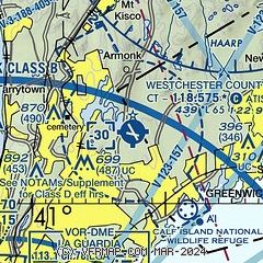
|
CAUTION: Diagram may not be current
 Download PDF
of official airport diagram from the FAA
| Airport distance calculator |
|---|
|
|
| Sunrise and sunset |
|---|
|
Times for 30-Jun-2025
| | Local
(UTC-4) | | Zulu
(UTC) |
|---|
| Morning civil twilight | | 04:53 | | 08:53 |
| Sunrise | | 05:27 | | 09:27 |
| Sunset | | 20:30 | | 00:30 |
| Evening civil twilight | | 21:04 | | 01:04 |
|
| Current date and time |
|---|
| Zulu (UTC) | 30-Jun-2025 21:44:51 |
|---|
| Local (UTC-4) | 30-Jun-2025 17:44:51 |
|---|
|
| METAR |
|---|
| KHPN | 302056Z 14008KT 10SM CLR 31/20 A2995 RMK AO2 SLP137 T03060200 55011
|
KLGA
19nm SW | 302051Z 16016G21KT 10SM SCT055 BKN190 BKN250 30/19 A2994 RMK AO2 SLP139 CB DSNT SW T03000194 55004 $
|
KTEB
20nm SW | 302051Z 18014G19KT 10SM CLR 32/19 A2993 RMK AO2 SLP134 T03220189 55007
|
|
| TAF |
|---|
| KHPN | 301951Z 3020/0118 15006KT P6SM FEW050 SCT250 FM010100 VRB03KT P6SM BKN120 FM010400 VRB03KT 4SM -SHRA BR BKN035 PROB30 0104/0108 3SM TSRA BR BKN025CB FM010800 VRB03KT 6SM BR SCT035 BKN120 FM011200 25007KT P6SM SCT040 BKN120 AMD NOT SKED
|
KLGA
19nm SW | 301951Z 3020/0124 16010KT P6SM SCT050 SCT150 SCT250 FM010000 16007KT P6SM BKN120 FM010400 20005KT 4SM -SHRA BR BKN040 PROB30 0104/0108 3SM TSRA BR BKN030CB FM010800 21005KT 6SM BR SCT040 BKN120 FM011200 23008KT P6SM SCT040 BKN120 FM011800 23012KT P6SM SCT040 BKN120 PROB30 0118/0124 3SM TSRA BR BKN030CB
|
KTEB
20nm SW | 301740Z 3018/0124 18005KT P6SM SCT150 BKN250 FM302000 17008KT P6SM FEW045 SCT150 BKN250 FM010100 19004KT P6SM BKN120 FM010400 21004KT 4SM -SHRA BR BKN040 PROB30 0104/0108 3SM TSRA BR BKN030CB FM010800 21004KT 6SM BR SCT040 BKN120 FM011300 23009KT P6SM SCT040 BKN120 FM011700 24010KT P6SM SCT040 BKN120 PROB30 0118/0124 3SM TSRA BR BKN030CB
|
|
| NOTAMs |
|---|
NOTAMs are issued by the DoD/FAA and will open in a separate window not controlled by AirNav.
|
|
FBO, Fuel Providers, and Aircraft Ground Support |
|---|
| | 
Business Name | |
Contact | |
Services / Description | |
Fuel Prices | |
Comments | |
|---|
 |
|
ASRI 132.00
914-682-7770
[web site]
[email] |
|
A short drive from Manhattan, White Plains boasts a thriving economy and scenic vistas. Considered to be a bedroom community for the greater New York City metropolis, White Plains is also a major corporate destination in its own right. Whatever your ultimate destination, Signature-White Plains can help make the arrangements.
Prior permission required from the airport for aircraft over 120,000 lbs MTOW, which the FBO can assist in obtaining.

|
|
 | | 100LL | Jet A | | FS | | $9.15 | | $7.98 | | Updated 28-Jun-2025 |
|
|

write
|
|
 |
|
ASRI 129.60
914-761-3000
[web site]
[email] |
|
Atlantic Aviation is your premier aviation service provider with more than 100 locations in North America, including Hawaii and the Caribbean. We provide standard ground services you'd expect, with a detailed focus on ensuring an unforgettable customer experience.


|
|
| | 100LL | Jet A | | FS | | $7.85 | | $7.98 | | Updated 30-Jun-2025 |
|
|
write
|
|
| Atlantic Aviation (West) |
|
914-328-9800
[web site]
[email] |
|
Aviation fuel, Aircraft parking (ramp or tiedown), Hangars, Catering, Rental cars, Courtesy transportation, ...
|
|
| independent | | 100LL | Jet A | | FS | | $7.85 | | $7.98 | | Updated 30-Jun-2025 |
|
|
1 read write
|
|
| Signature Aviation (west) |
|
914-428-3730
[web site]
[email] |
|
Aviation fuel, Oxygen service, Aircraft parking (ramp or tiedown), Hangars, Passenger terminal and lounge, Aircraft charters, Aircraft sales / leasing / brokerage, ...
|
|
| independent | | 100LL | Jet A | | FS | | $9.15 | | $7.98 | | Updated 28-Jun-2025 |
|
|
write
|
|
|
|
|
914-946-0100
[web site]
[email]

|
|
Aviation fuel, Aircraft parking (ramp or tiedown), Hangars, Passenger terminal and lounge, Aircraft maintenance, Aircraft interiors, Aviation accessories, ...


|
|
 | | 100LL | Jet A | | FS | | $8.06 | | $9.53 | | Updated 24-Jun-2025 |
|
|
1 read write
|
|

|
| |
Aviation Businesses, Services, and Facilities |
|---|
| |
Business Name | |
Contact | |
Services / Description | |
Distance | |
Comments | |
|---|
 |
|
914-461-2336
631-777-7772
[web site]
[email] |
|
Flight training, Aircraft rental, Pilot supplies


|
|
on airport |
|
write
|
|
 |
|
914-469-8187
[web site]
[email] |
|
24/7 On-Call Rapid AOG Mobile Aircraft Maintenance Teams
Westchester County Airport (HPN), 85 Tower Rd White Plains, NY
Veteran owned company providing aircraft maintenance.
|
|
on airport |
|
write
|
|
|
|
|
914-397-1444
[web site]
[email] |
|
Cirrus Platinum Flight Training and Authorized Service Center offering flight training, aircraft rental, maintenance, aircraft management, pilot services, pilot shop, and charter

|
|
on airport |
|
write
|
|
| Westchester Flying Club |
|
203-463-5116
[web site]
[email] |
|
Flight training, Flying club
|
|
on airport |
|
write
|
|
| |
Would you like to see your business listed on this page? |
|---|
| | If your business provides an interesting product or service to pilots, flight crews, aircraft, or users of the Westchester County Airport, you should consider listing it here. To start the listing process, click on the button below

|


