FAA INFORMATION EFFECTIVE 22 JANUARY 2026
Location
| FAA Identifier: | JCT |
| Lat/Long: | 30-30-40.0000N 099-45-46.4000W
30-30.666667N 099-45.773333W
30.5111111,-99.7628889
(estimated) |
| Elevation: | 1753.6 ft. / 534.5 m (surveyed) |
| Variation: | 08E (1980) |
| From city: | 1 mile NE of JUNCTION, TX |
| Time zone: | UTC -6 (UTC -5 during Daylight Saving Time) |
| Zip code: | 76849 |
Airport Operations
| Airport use: | Open to the public |
| Activation date: | 03/1978 |
| Control tower: | no |
| ARTCC: | HOUSTON CENTER |
| FSS: | SAN ANGELO FLIGHT SERVICE STATION |
| NOTAMs facility: | JCT (NOTAM-D service available) |
| Attendance: | CONTINUOUS |
| Wind indicator: | lighted |
| Segmented circle: | yes |
| Lights: | DUSK-DAWN. MIRL RWY 17/35 PRESET LOW INTST; TO INCR INTST ACTVT - CTAF. |
| Beacon: | white-green (lighted land airport)
Operates sunset to sunrise. |
Airport Communications
| CTAF/UNICOM: | 122.8 |
| WX ASOS: | 119.275 (325-244-2722) |
- APCH/DEP CTL SVC PRVDD BY HOUSTON ARTCC (ZHU) ON FREQS 125.75/346.4 (ROCK SPRINGS RCAG).
Nearby radio navigation aids
| VOR radial/distance | | VOR name | | Freq | | Var |
|---|
| JCTr144/5.9 | | JUNCTION VORTAC | | 116.00 | | 08E |
Airport Services
| Fuel available: | 100LL JET-A+ |
| Parking: | tiedowns |
| Airframe service: | MAJOR |
| Powerplant service: | MAJOR |
| Bottled oxygen: | NONE |
| Bulk oxygen: | NONE |
Runway Information
Runway 17/35
| Dimensions: | 5004 x 75 ft. / 1525 x 23 m |
| Surface: | asphalt, in fair condition |
| Weight bearing capacity: | |
| Runway edge lights: | medium intensity |
| RUNWAY 17 | | RUNWAY 35 |
| Latitude: | 30-31.062217N | | 30-30.236910N |
| Longitude: | 099-45.863160W | | 099-45.868710W |
| Elevation: | 1753.6 ft. | | 1703.2 ft. |
| Traffic pattern: | left | | left |
| Runway heading: | 172 magnetic, 180 true | | 352 magnetic, 000 true |
| Markings: | nonprecision, in fair condition | | nonprecision, in fair condition |
| Visual slope indicator: | 4-light PAPI on left (3.50 degrees glide path)
UNUSBL BYD 5DEG LEFT OF CL. | | 4-light PAPI on left (3.00 degrees glide path) |
| Touchdown point: | yes, no lights | | yes, no lights |
| Obstructions: | 200 ft. hill, 4400 ft. from runway, 21:1 slope to clear | | 45 ft. trees, 1730 ft. from runway, 34:1 slope to clear |
Runway 8/26
| Dimensions: | 2255 x 130 ft. / 687 x 40 m |
| Surface: | turf, in fair condition |
| Runway edge markings: | RWY 08 & RWY 26 THRS MKD WITH WHITE TIRES. |
| RUNWAY 8 | | RUNWAY 26 |
| Latitude: | 30-30.711793N | | 30-30.697783N |
| Longitude: | 099-45.780407W | | 099-45.351095W |
| Elevation: | 1721.4 ft. | | 1698.5 ft. |
| Traffic pattern: | left | | left |
| Runway heading: | 084 magnetic, 092 true | | 264 magnetic, 272 true |
| Touchdown point: | yes, no lights | | yes, no lights |
| Obstructions: | none | | 34 ft. trees, 500 ft. from runway, 130 ft. right of centerline, 14:1 slope to clear |
Airport Ownership and Management from official FAA records
| Ownership: | Publicly-owned |
| Owner: | KIMBLE COUNTY
KIMBLE COUNTY COURTHOUSE, 501 MAIN
JUNCTION, TX 76849
Phone 325-446-2724 |
| Manager: | DALLAS ANDRUS
635 AIRPORT ROAD, 501 MAIN
JUNCTION, TX 76849
Phone 325-446-2820 |
Additional Remarks
| - | FQT MIL TRNG FLTS CONDUCTING LOW APCHS TO ARPT. |
| - | FOR CD CTC HOUSTON ARTCC AT 281-230-5622. |
Instrument Procedures
NOTE: All procedures below are presented as PDF files. If you need a reader for these files, you should download the free Adobe Reader.NOT FOR NAVIGATION. Please procure official charts for flight.
FAA instrument procedures published for use from 22 January 2026 at 0901Z to 19 February 2026 at 0900z.
IAPs - Instrument Approach Procedures |
|---|
| RNAV (GPS) RWY 17 | |
download (165KB) |
| VOR-A | |
download (145KB) |
| NOTE: Special Take-Off Minimums/Departure Procedures apply | |
download (105KB) |
Other nearby airports with instrument procedures:
T92 - Mason County Airport (33 nm NE)
KECU - Edwards County Airport (40 nm SW)
KSOA - Sonora Municipal Airport (46 nm W)
KBBD - Curtis Field Airport (46 nm NE)
T82 - Gillespie County Airport (47 nm E)
|
|

Road maps at:
MapQuest
Bing
Google
| Aerial photo |
|---|
WARNING: Photo may not be current or correct

Do you have a better or more recent aerial photo of Kimble County Airport that you would like to share? If so, please send us your photo.
|
| Sectional chart |
|---|
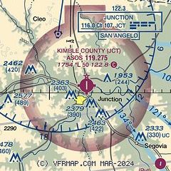
|
| Airport distance calculator |
|---|
|
|
| Sunrise and sunset |
|---|
|
Times for 24-Jan-2026
| | Local
(UTC-6) | | Zulu
(UTC) |
|---|
| Morning civil twilight | | 07:10 | | 13:10 |
| Sunrise | | 07:35 | | 13:35 |
| Sunset | | 18:07 | | 00:07 |
| Evening civil twilight | | 18:33 | | 00:33 |
|
| Current date and time |
|---|
| Zulu (UTC) | 24-Jan-2026 19:26:04 |
|---|
| Local (UTC-6) | 24-Jan-2026 13:26:04 |
|---|
|
| METAR |
|---|
| KJCT | 241901Z AUTO 02010KT 2 1/2SM BR OVC007 M06/M06 A3010 RMK AO2 I1000 T10561061 $
|
|
| TAF |
|---|
| KJCT | 241731Z 2418/2518 01013KT 2SM -FZDZ BR OVC007 TEMPO 2418/2422 1SM -FZDZ BR OVC004 FM242200 02012KT 5SM -FZRA BR OVC007 FM250600 02010KT 2SM -FZRAPL BR OVC004
|
|
| NOTAMs |
|---|
NOTAMs are issued by the DoD/FAA and will open in a separate window not controlled by AirNav.
|
|

