FAA INFORMATION EFFECTIVE 16 APRIL 2026
Location
| FAA Identifier: | JFZ |
| Lat/Long: | 37-03-49.4870N 081-47-53.7570W
37-03.824783N 081-47.895950W
37.0637464,-81.7982658
(estimated) |
| Elevation: | 2653.1 ft. / 808.7 m (surveyed) |
| Variation: | 06W (1995) |
| From city: | 2 miles S of RICHLANDS, VA |
| Time zone: | UTC -4 (UTC -5 during Standard Time) |
| Zip code: | 24609 |
Airport Operations
| Airport use: | Open to the public |
| Activation date: | 11/1991 |
| Control tower: | no |
| ARTCC: | ATLANTA CENTER |
| FSS: | LEESBURG FLIGHT SERVICE STATION |
| NOTAMs facility: | JFZ (NOTAM-D service available) |
| Attendance: | MON-SAT 0830-1630
UNATNDD NEW YEARS, THANKSGIVING, & CHRISTMAS.
FOR SUN SVC, CALL APRT DURG RGLR BUS HRS TO ARNG. AFT HRS NRS LISTED ON DOOR. |
| Wind indicator: | lighted |
| Segmented circle: | yes |
| Lights: | MIRL RWY 07/25 PRESET LOW INTST. TO INCREASE INTST & ACTVT REIL RWYS 07 & 25; PAPI RWY 07 & 25 - CTAF. |
| Beacon: | white-green (lighted land airport)
Operates sunset to sunrise. |
Airport Communications
| CTAF/UNICOM: | 123.05 |
| WX AWOS-3: | 118.075 (276-596-9927) |
- APCH/DEP SVC PRVDD BY ATLANTA ARTCC (ZTL) ON FREQS 127.85/269.3 (GLADE SPRINGS RCAG).
Nearby radio navigation aids
| VOR radial/distance | | VOR name | | Freq | | Var |
|---|
| GZGr045/19.7 | | GLADE SPRING VOR/DME | | 115.55 | | 02W |
| BLFr246/32.3 | | BLUEFIELD VOR/DME | | 115.05 | | 03W |
Airport Services
| Fuel available: | 100LL JET-A+ |
| Parking: | tiedowns |
Runway Information
Runway 7/25
| Dimensions: | 4299 x 75 ft. / 1310 x 23 m |
| Surface: | asphalt, in good condition |
| Weight bearing capacity: | | Single wheel: | 12.5 | | Double wheel: | 18.0 |
|
| Runway edge lights: | medium intensity |
| RUNWAY 7 | | RUNWAY 25 |
| Latitude: | 37-03.678617N | | 37-03.970920N |
| Longitude: | 081-48.298492W | | 081-47.493395W |
| Elevation: | 2652.8 ft. | | 2653.1 ft. |
| Traffic pattern: | left | | left |
| Runway heading: | 072 magnetic, 066 true | | 252 magnetic, 246 true |
| Markings: | nonprecision, in good condition | | nonprecision, in good condition |
| Visual slope indicator: | 2-light PAPI on left (3.50 degrees glide path) | | 2-light PAPI on left (3.50 degrees glide path) |
| Runway end identifier lights: | yes | | yes |
| Touchdown point: | yes, no lights | | yes, no lights |
| Instrument approach: | | | LOC/DME |
| Obstructions: | 8 ft. trees, 204 ft. from runway, 132 ft. left of centerline
BRUSH 113 FT L OF CNTRLN AND OVER EMBANKMENT ADJ TO RWY. | | 17 ft. tree, 227 ft. from runway, 131 ft. left of centerline, 1:1 slope to clear |
Airport Ownership and Management from official FAA records
| Ownership: | Publicly-owned |
| Owner: | TAZEWELL CO AIRPORT AUTHORITY
2200 AIRPORT ROAD
CEDAR BLUFF, VA 24609
Phone 276-963-4509 |
| Manager: | JAMES FRENCH
2200 AIRPORT ROAD
CEDAR BLUFF, VA 24609
Phone 276-963-4509 |
Additional Remarks
| - | GCO AVBL ON FREQ 135.075 THRU ZTL CLEARANCE DELIVERY AND DCA RADIO - INOP. |
| - | FOR CD IF UNA VIA GCO CTC ATLANTA ARTCC AT 770-210-7692. |
Instrument Procedures
NOTE: All procedures below are presented as PDF files. If you need a reader for these files, you should download the free Adobe Reader.NOT FOR NAVIGATION. Please procure official charts for flight.
FAA instrument procedures published for use from 16 April 2026 at 0901Z to 14 May 2026 at 0900Z.
IAPs - Instrument Approach Procedures |
|---|
| RNAV (GPS) RWY 07 | |
download (218KB) |
| RNAV (GPS) RWY 25 | |
download (256KB) |
| LOC/DME RWY 25 | |
download (257KB) |
| NOTE: Special Alternate Minimums apply | |
download (22KB) |
| NOTE: Special Take-Off Minimums/Departure Procedures apply | |
download (140KB) |
Other nearby airports with instrument procedures:
KMKJ - Mountain Empire Airport (24 nm SE)
KVJI - Virginia Highlands Airport (25 nm SW)
KBLF - Mercer County Airport (31 nm NE)
I16 - Kee Field Airport (34 nm N)
KLNP - Lonesome Pine Airport (35 nm W)
|
|

Road maps at:
MapQuest
Bing
Google
| Aerial photo |
|---|
WARNING: Photo may not be current or correct
 Photo courtesy of Dominion Aerial Photography, LLC dominionaerialphotography.com
Photo taken 01-Jun-2013
looking north-northwest.
Photo courtesy of Dominion Aerial Photography, LLC dominionaerialphotography.com
Photo taken 01-Jun-2013
looking north-northwest.
Do you have a better or more recent aerial photo of Tazewell County Airport that you would like to share? If so, please send us your photo.
|
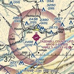
| Sectional chart |
|---|
|
| Airport distance calculator |
|---|
|
|
| Sunrise and sunset |
|---|
|
Times for 03-May-2026
| | Local
(UTC-4) | | Zulu
(UTC) |
|---|
| Morning civil twilight | | 06:03 | | 10:03 |
| Sunrise | | 06:32 | | 10:32 |
| Sunset | | 20:17 | | 00:17 |
| Evening civil twilight | | 20:45 | | 00:45 |
|
| Current date and time |
|---|
| Zulu (UTC) | 03-May-2026 21:25:13 |
|---|
| Local (UTC-4) | 03-May-2026 17:25:13 |
|---|
|
| METAR |
|---|
| KJFZ | 032055Z AUTO 23003KT 10SM CLR 13/M05 A3004 RMK AO2 T01311047
|
|
| TAF |
|---|
KBLF
32nm NE | 031720Z 0318/0418 29006KT P6SM SKC FM040000 VRB03KT P6SM FEW250 FM041300 24007KT P6SM SCT100
|
|
| NOTAMs |
|---|
NOTAMs are issued by the DoD/FAA and will open in a separate window not controlled by AirNav.
|
|

