FAA INFORMATION EFFECTIVE 14 MAY 2026
Location
| FAA Identifier: | AFO |
| Lat/Long: | 42-42-31.5740N 110-56-31.8160W
42-42.526233N 110-56.530267W
42.7087706,-110.9421711
(estimated) |
| Elevation: | 6220.9 ft. / 1896.1 m (surveyed) |
| Variation: | 14E (2000) |
| From city: | 1 mile SW of AFTON, WY |
| Time zone: | UTC -6 (UTC -7 during Standard Time) |
| Zip code: | 83110 |
Airport Operations
| Airport use: | Open to the public |
| Activation date: | 07/1942 |
| Control tower: | no |
| ARTCC: | SALT LAKE CITY CENTER |
| FSS: | CASPER FLIGHT SERVICE STATION |
| NOTAMs facility: | CPR (NOTAM-D service available) |
| Attendance: | MON-FRI 0700-1600, MAY-SEPT SAT 0800-1200 |
| Wind indicator: | lighted |
| Segmented circle: | yes |
| Lights: | ACTVT REIL RWY 16 & 34; MIRL RWY 16/34 - CTAF. PAPI RWY 16 & 34 OPR CONSLY. |
| Beacon: | white-green (lighted land airport)
Operates sunset to sunrise. |
| Landing fee: | yes |
Airport Communications
| CTAF/UNICOM: | 122.8 |
| WX AWOS-3PT: | 119.025 (307-885-2654) |
- APCH/DEP CTL SVC PRVDD BY SALT LAKE ARTCC (ZLC) ON FREQS 128.35/239.25 (BLACKFOOT RCAG).
- COMMUNICATIONS PRVDD BY CASPER RADIO ON FREQ 122.3 (BIG PINEY RCO).
Nearby radio navigation aids
| VOR radial/distance | | VOR name | | Freq | | Var |
|---|
| BPIr272/37.6 | | BIG PINEY VOR/DME | | 116.50 | | 10E |
Airport Services
| Fuel available: | 100LL JET-A
100LL:AVBL H24 SELF SVC VIA CREDIT CARD. FULL SERVICE AVBL WITH CALL OUT 307-885-7030.
A:FUEL 24 HR CREDIT CARD SVC; FULL SVC JET AVBL WITH CALLOUT 307-8881485. |
| Parking: | hangars and tiedowns |
| Airframe service: | MAJOR |
| Powerplant service: | MAJOR |
| Bottled oxygen: | NONE |
| Bulk oxygen: | LOW |
Runway Information
Runway 16/34
| Dimensions: | 7025 x 75 ft. / 2141 x 23 m |
| Surface: | asphalt, in good condition |
| Weight bearing capacity: | |
| Runway edge lights: | medium intensity |
| RUNWAY 16 | | RUNWAY 34 |
| Latitude: | 42-43.104315N | | 42-41.948148N |
| Longitude: | 110-56.528250W | | 110-56.532295W |
| Elevation: | 6187.7 ft. | | 6220.9 ft. |
| Traffic pattern: | right | | left |
| Runway heading: | 166 magnetic, 180 true | | 346 magnetic, 000 true |
| Markings: | nonprecision, in fair condition | | nonprecision, in fair condition |
| Visual slope indicator: | 4-light PAPI on left (3.50 degrees glide path) | | 4-light PAPI on left (3.50 degrees glide path)
RWY 34 PAPI DOES NOT PRVD OBST CLNC BYD 5.0 NM FM THR, UNUSBL BYD 5.0 NM. |
| Runway end identifier lights: | yes | | yes |
| Touchdown point: | yes, no lights | | yes, no lights |
| Obstructions: | 51 ft. pole, 1290 ft. from runway, 278 ft. left of centerline, 21:1 slope to clear | | 90 ft. tree, 2014 ft. from runway, 185 ft. right of centerline, 19:1 slope to clear |
Airport Ownership and Management from official FAA records
| Ownership: | Publicly-owned |
| Owner: | TOWN OF AFTON
BOX 1181
AFTON, WY 83110
Phone (307) 885-9831
ALSO LINCOLN COUNTY-307-877-2004. |
| Manager: | HEATH LAWSON
BOX 1181
AFTON, WY 83110
Phone 307-885-3245 |
Additional Remarks
| - | SNBNKS 4 FT TO 7 FT ALG RWYS & TXYS EDGES FM NOV-APR WITH SLICK SPOTS ALL SFCS. |
| - | COLD TEMPERATURE AIRPORT. ALTITUDE CORRECTION REQUIRED AT OR BELOW -18C. |
| - | FOR CD CTC SALT LAKE ARTCC AT 801-320-2568. |
| - | WILDLIFE ON & INVOF ARPT. |
Instrument Procedures
NOTE: All procedures below are presented as PDF files. If you need a reader for these files, you should download the free Adobe Reader.NOT FOR NAVIGATION. Please procure official charts for flight.
FAA instrument procedures published for use from 14 May 2026 at 0901Z to 11 June 2026 at 0900Z.
IAPs - Instrument Approach Procedures |
|---|
| RNAV (GPS) RWY 16 | |
download (776KB) |
| RNAV (GPS) RWY 34 | |
download (834KB) |
| NOTE: Special Alternate Minimums apply | |
download (212KB) |
|
|---|
| AFTON FOUR (OBSTACLE) (RNAV) | |
download (182KB) |
| LUNDI TWO (OBSTACLE) (RNAV) | |
download (117KB) |
| NOTE: Special Take-Off Minimums/Departure Procedures apply | |
download (560KB) |
Other nearby airports with instrument procedures:
1U7 - Bear Lake County Airport (33 nm SW)
KBPI - Miley Memorial Field Airport (38 nm E)
KPNA - Ralph Wenz Field Airport (50 nm E)
KJAC - Jackson Hole Airport (55 nm N)
KEMM - Kemmerer Municipal Airport (56 nm S)
|
|

Road maps at:
MapQuest
Bing
Google
| Aerial photo |
|---|
WARNING: Photo may not be current or correct
 Photo taken 22-Jul-2016
looking northeast.
Photo taken 22-Jul-2016
looking northeast.
Do you have a better or more recent aerial photo of Afton Lincoln County Airport/General Boyd L Eddins Field that you would like to share? If so, please send us your photo.
|
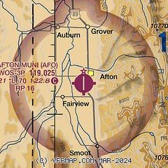
| Sectional chart |
|---|
|
CAUTION: Diagram may not be current

| Airport distance calculator |
|---|
|
|
| Sunrise and sunset |
|---|
|
Times for 20-May-2026
| | Local
(UTC-6) | | Zulu
(UTC) |
|---|
| Morning civil twilight | | 05:24 | | 11:24 |
| Sunrise | | 05:57 | | 11:57 |
| Sunset | | 20:43 | | 02:43 |
| Evening civil twilight | | 21:16 | | 03:16 |
|
| Current date and time |
|---|
| Zulu (UTC) | 20-May-2026 15:10:12 |
|---|
| Local (UTC-6) | 20-May-2026 09:10:12 |
|---|
|
| METAR |
|---|
| KAFO | 201455Z AUTO 00000KT 10SM OVC095 03/00 A3018 RMK AO2
|
|
| TAF |
|---|
KBPI
38nm E | 201359Z 2012/2112 02004KT P6SM FEW080 FM201600 25006KT P6SM FEW090 FM202000 30012G20KT P6SM SCT090 BKN120 FM210200 32009KT P6SM SCT070 BKN100 FM211000 31007KT P6SM SCT030 OVC050 PROB30 2110/2112 6SM -SHRA BKN030
|
|
| NOTAMs |
|---|
NOTAMs are issued by the DoD/FAA and will open in a separate window not controlled by AirNav.
|
|


