FAA INFORMATION EFFECTIVE 14 MAY 2026
Location
| FAA Identifier: | EMM |
| Lat/Long: | 41-49-26.7000N 110-33-25.0000W
41-49.445000N 110-33.416667W
41.8240833,-110.5569444
(estimated) |
| Elevation: | 7288.7 ft. / 2221.6 m (surveyed) |
| Variation: | 11E (2015) |
| From city: | 2 miles NW of KEMMERER, WY |
| Time zone: | UTC -6 (UTC -7 during Standard Time) |
| Zip code: | 83101 |
Airport Operations
| Airport use: | Open to the public |
| Activation date: | 11/1937 |
| Control tower: | no |
| ARTCC: | SALT LAKE CITY CENTER |
| FSS: | CASPER FLIGHT SERVICE STATION |
| NOTAMs facility: | CPR (NOTAM-D service available) |
| Attendance: | UNATNDD |
| Wind indicator: | lighted |
| Segmented circle: | yes
SEGMENTED CIRCLE DOES NOT DEPICT RIGHT HAND TRAFFIC FOR RY 22. |
| Lights: | ACTVT REIL RWYS 16 & 34; PAPI RWYS 16 & 34; MIRL RWYS 04/22 & 16/34 - CTAF. |
| Beacon: | white-green (lighted land airport)
Operates sunset to sunrise. |
Airport Communications
| CTAF/UNICOM: | 122.8 |
| WX AWOS-3PT: | 119.675 (307-877-9838) |
- APCH/DEP CTL SVC PRVDD BY SALT LAKE CITY ARTCC (ZLC) ON FREQS 124.35/353.5 (GREEN RIVER RCAG).
Nearby radio navigation aids
| VOR radial/distance | | VOR name | | Freq | | Var |
|---|
| FBRr333/27.4 | | FORT BRIDGER VOR/DME | | 114.45 | | 14E |
| EVWr021/39.7 | | EVANSTON VOR/DME | | 109.60 | | 13E |
Airport Services
| Fuel available: | 100LL JET-A
100LL:FUEL AVBL H24 VIA SELF SVC CREDIT CARD READER LCTD INSIDE PILOT LOUNGE EAST DOOR. |
| Parking: | hangars and tiedowns |
| Airframe service: | NONE |
| Powerplant service: | NONE |
| Bottled oxygen: | NONE |
| Bulk oxygen: | NONE |
Runway Information
Runway 16/34
| Dimensions: | 8203 x 75 ft. / 2500 x 23 m |
| Surface: | asphalt, in good condition |
| Weight bearing capacity: | |
| Runway edge lights: | medium intensity |
| RUNWAY 16 | | RUNWAY 34 |
| Latitude: | 41-49.987742N | | 41-48.645575N |
| Longitude: | 110-33.538605W | | 110-33.341767W |
| Elevation: | 7288.7 ft. | | 7275.9 ft. |
| Traffic pattern: | left | | left |
| Runway heading: | 163 magnetic, 174 true | | 343 magnetic, 354 true |
| Markings: | nonprecision, in good condition | | nonprecision, in good condition |
| Visual slope indicator: | 2-light PAPI on left (3.25 degrees glide path) | | 2-light PAPI on left (3.25 degrees glide path) |
| Runway end identifier lights: | yes | | yes |
| Touchdown point: | yes, no lights | | yes, no lights |
Runway 4/22
| Dimensions: | 2671 x 60 ft. / 814 x 18 m |
| Surface: | concrete, in fair condition |
| Weight bearing capacity: | |
| Runway edge lights: | medium intensity |
| RUNWAY 4 | | RUNWAY 22 |
| Latitude: | 41-49.395513N | | 41-49.653517N |
| Longitude: | 110-33.635007W | | 110-33.159005W |
| Elevation: | 7285.8 ft. | | 7284.3 ft. |
| Traffic pattern: | left | | right |
| Runway heading: | 043 magnetic, 054 true | | 223 magnetic, 234 true |
| Markings: | basic, in fair condition | | basic, in fair condition |
| Touchdown point: | yes, no lights | | yes, no lights |
Runway 10/28
| Dimensions: | 3271 x 60 ft. / 997 x 18 m |
| Surface: | turf/dirt, in fair condition |
| RUNWAY 10 | | RUNWAY 28 |
| Latitude: | 41-49.839360N | | 41-49.567017N |
| Longitude: | 110-33.680068W | | 110-33.059050W |
| Elevation: | 7287.2 ft. | | 7280.1 ft. |
| Traffic pattern: | left | | left |
| Runway heading: | 110 magnetic, 121 true | | 290 magnetic, 301 true |
| Markings: | none, in good condition | | none, in good condition |
| Touchdown point: | yes, no lights | | yes, no lights |
| Obstructions: | none | | 7 ft. fence, 105 ft. from runway, 16:1 slope to clear |
Airport Ownership and Management from official FAA records
| Ownership: | Publicly-owned |
| Owner: | CITY OF KEMMERER
220 WYO HIWAY 233
KEMMERER, WY 83101
Phone 307-828-2350
ALSO LINCOLN COUNTY - 307-877-9056 |
| Manager: | CHAD NIELSON
220 WYO HIWAY. 233
KEMMERER, WY 83101
Phone 307-727-7856
FOR ASSISTANCE AFT HRS PHONE 307-727-7856 |
Additional Remarks
| - | TERRAIN DROPS OFF STEEPLY 55' PRIOR TO APCH END RY 10. |
| - | FOR CD CTC SALT LAKE ARTCC AT 801-320-2568. |
| - | TERRAIN DROPS OFF STEEPLY 81' PRIOR TO APCH END RY 4. |
Instrument Procedures
NOTE: All procedures below are presented as PDF files. If you need a reader for these files, you should download the free Adobe Reader.NOT FOR NAVIGATION. Please procure official charts for flight.
FAA instrument procedures published for use from 14 May 2026 at 0901Z to 11 June 2026 at 0900Z.
IAPs - Instrument Approach Procedures |
|---|
| RNAV (GPS) RWY 16 | |
download (242KB) |
| RNAV (GPS) RWY 34 | |
download (249KB) |
| NOTE: Special Alternate Minimums apply | |
download (59KB) |
Departure Procedures |
|---|
| KEMRR FIVE (RNAV) | |
download (126KB) |
| NOTE: Special Take-Off Minimums/Departure Procedures apply | |
download (318KB) |
Other nearby airports with instrument procedures:
KFBR - Fort Bridger Airport (27 nm S)
KEVW - Evanston-Uinta County Airport - Burns Field (39 nm SW)
1U7 - Bear Lake County Airport (43 nm NW)
KBPI - Miley Memorial Field Airport (50 nm NE)
KAFO - Afton Lincoln County Airport/General Boyd L Eddins Field (56 nm N)
|
|

Road maps at:
MapQuest
Bing
Google
| Aerial photo |
|---|
WARNING: Photo may not be current or correct
 Photo by Mitch Bowers Imagewerx.us Aerial Photography
Photo taken 03-Sep-2011
looking southeast.
Do you have a better or more recent aerial photo of Kemmerer Municipal Airport that you would like to share? If so, please send us your photo.
|
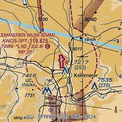
| Sectional chart |
|---|
|
| Airport distance calculator |
|---|
|
|
| Sunrise and sunset |
|---|
|
Times for 23-May-2026
| | Local
(UTC-6) | | Zulu
(UTC) |
|---|
| Morning civil twilight | | 05:23 | | 11:23 |
| Sunrise | | 05:56 | | 11:56 |
| Sunset | | 20:42 | | 02:42 |
| Evening civil twilight | | 21:14 | | 03:14 |
|
| Current date and time |
|---|
| Zulu (UTC) | 24-May-2026 00:02:26 |
|---|
| Local (UTC-6) | 23-May-2026 18:02:26 |
|---|
|
| METAR |
|---|
| KEMM | 232355Z AUTO 30017G22KT 10SM CLR 19/M08 A3010 RMK AO2
|
|
| TAF |
|---|
KEVW
40nm SW | 231734Z 2318/2418 25014G22KT P6SM FEW100 SCT250 FM240100 26009KT P6SM SCT100 BKN250 FM240400 19006KT P6SM SCT100 BKN150 FM241600 25010G18KT P6SM SCT100 BKN120
|
|
| NOTAMs |
|---|
NOTAMs are issued by the DoD/FAA and will open in a separate window not controlled by AirNav.
|
|

