FAA INFORMATION EFFECTIVE 16 APRIL 2026
Location
| FAA Identifier: | BGD |
| Lat/Long: | 35-42-03.2000N 101-23-37.2000W
35-42.053333N 101-23.620000W
35.7008889,-101.3936667
(estimated) |
| Elevation: | 3055.2 ft. / 931.2 m (surveyed) |
| Variation: | 07E (2010) |
| From city: | 2 miles N of BORGER, TX |
| Time zone: | UTC -5 (UTC -6 during Standard Time) |
| Zip code: | 79007 |
Airport Operations
| Airport use: | Open to the public |
| Activation date: | 10/1950 |
| Control tower: | no |
| ARTCC: | ALBUQUERQUE CENTER |
| FSS: | FORT WORTH FLIGHT SERVICE STATION |
| NOTAMs facility: | BGD (NOTAM-D service available) |
| Attendance: | 0800-1800 |
| Wind indicator: | lighted |
| Segmented circle: | yes |
| Lights: | ACTVT PAPI RWYS 17 & 35; MIRL RWYS 03/21 & 17/35 - CTAF. |
| Beacon: | white-green (lighted land airport)
Operates sunset to sunrise. |
Airport Communications
| CTAF/UNICOM: | 123.0 |
| WX ASOS: | 118.325 (806-274-7318) |
| AMARILLO APPROACH: | 119.5 |
| ALBUQUERQUE ARTCC APPROACH: | 121.15 |
| AMARILLO DEPARTURE: | 119.5 |
| ALBUQUERQUE ARTCC DEPARTURE: | 121.15 |
- APCH/DEP SVC PRVDD BY ALBUQUERQUE ARTCC (ZAB) ON FREQS 127.85/285.475 (AMARILLO RCAG) WHEN AMARILLO APCH CTL (AMA) CLSD.
Nearby radio navigation aids
| VOR radial/distance | | VOR name | | Freq | | Var |
|---|
| PNHr020/31.7 | | PANHANDLE VORTAC | | 116.60 | | 08E |
Airport Services
| Fuel available: | 100LL JET-A+ |
| Parking: | hangars and tiedowns |
Runway Information
Runway 17/35
| Dimensions: | 6299 x 100 ft. / 1920 x 30 m |
| Surface: | asphalt, in excellent condition |
| Weight bearing capacity: | | Single wheel: | 60.0 | | Double wheel: | 100.0 |
|
| Runway edge lights: | medium intensity |
| RUNWAY 17 | | RUNWAY 35 |
| Latitude: | 35-42.600700N | | 35-41.563102N |
| Longitude: | 101-23.624125W | | 101-23.588045W |
| Elevation: | 2998.3 ft. | | 3055.2 ft. |
| Traffic pattern: | left | | left |
| Runway heading: | 171 magnetic, 178 true | | 351 magnetic, 358 true |
| Markings: | nonprecision, in good condition | | nonprecision, in good condition |
| Visual slope indicator: | 4-light PAPI on left (3.00 degrees glide path) | | 4-light PAPI on right (3.00 degrees glide path) |
| Touchdown point: | yes, no lights | | yes, no lights |
| Obstructions: | 18 ft. pole, 230 ft. from runway, 408 ft. left of centerline, 1:1 slope to clear | | 52 ft. trees, 1420 ft. from runway, 42 ft. right of centerline, 23:1 slope to clear |
Runway 3/21
| Dimensions: | 3897 x 100 ft. / 1188 x 30 m |
| Surface: | asphalt, in excellent condition |
| Weight bearing capacity: | | Single wheel: | 60.0 | | Double wheel: | 100.0 |
|
| Runway edge lights: | medium intensity |
| RUNWAY 3 | | RUNWAY 21 |
| Latitude: | 35-41.761552N | | 35-42.254422N |
| Longitude: | 101-23.894305W | | 101-23.389423W |
| Elevation: | 3035.3 ft. | | 3017.2 ft. |
| Traffic pattern: | left | | left |
| Runway heading: | 033 magnetic, 040 true | | 213 magnetic, 220 true |
| Markings: | basic, in good condition | | basic, in good condition |
| Touchdown point: | yes, no lights | | yes, no lights |
Airport Ownership and Management from official FAA records
| Ownership: | Publicly-owned |
| Owner: | HUTCHINSON COUNTY
COUNTY COURTHOUSE
STINNETT, TX 79083
Phone 806-878-4000 |
| Manager: | BATHAZAR MEDRANO
BOX 3470
BORGER, TX 79008
Phone 806-273-0137 |
Additional Remarks
| A58-03 | 15 FT TREE, 130 FT DSTC, 95 FT L. |
| - | FOR CD CTC ALBUQUERQUE ARTCC AT 505-856-4861. |
| - | RWY 21, 100 FT DROP-OFF, 95 FT DSTC. |
| - | RWY 3, 40 FT DROP-OFF, 150 FT DSTC. |
Instrument Procedures
NOTE: All procedures below are presented as PDF files. If you need a reader for these files, you should download the free Adobe Reader.NOT FOR NAVIGATION. Please procure official charts for flight.
FAA instrument procedures published for use from 16 April 2026 at 0901Z to 14 May 2026 at 0900Z.
IAPs - Instrument Approach Procedures |
|---|
| RNAV (GPS) RWY 17 | |
download (243KB) |
| RNAV (GPS) RWY 35 | |
download (252KB) |
| NOTE: Special Alternate Minimums apply | |
download (138KB) |
| NOTE: Special Take-Off Minimums/Departure Procedures apply | |
download (309KB) |
Other nearby airports with instrument procedures:
KPPA - Perry Lefors Field Airport (20 nm E)
T45 - Panhandle-Carson County Airport (20 nm S)
KDUX - Moore County Airport (32 nm W)
E19 - Gruver Municipal Airport (32 nm N)
E42 - Major Samuel B Cornelius Field Airport (33 nm N)
|
|

Road maps at:
MapQuest
Bing
Google
| Aerial photo |
|---|
WARNING: Photo may not be current or correct

Do you have a better or more recent aerial photo of Hutchinson County Airport that you would like to share? If so, please send us your photo.
|
| Sectional chart |
|---|
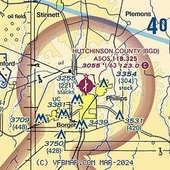
|
| Airport distance calculator |
|---|
|
|
| Sunrise and sunset |
|---|
|
Times for 20-Apr-2026
| | Local
(UTC-5) | | Zulu
(UTC) |
|---|
| Morning civil twilight | | 06:41 | | 11:41 |
| Sunrise | | 07:07 | | 12:07 |
| Sunset | | 20:22 | | 01:22 |
| Evening civil twilight | | 20:48 | | 01:48 |
|
| Current date and time |
|---|
| Zulu (UTC) | 20-Apr-2026 20:19:45 |
|---|
| Local (UTC-5) | 20-Apr-2026 15:19:45 |
|---|
|
| METAR |
|---|
| KBGD | 201951Z AUTO 19019G28KT 10SM CLR 25/08 A3010 RMK AO2 PK WND 17034/1932 SLP165 T02500083
|
|
| TAF |
|---|
KAMA
33nm SW | 201720Z 2018/2118 19018G28KT P6SM SCT050 FM210300 19014KT P6SM FEW015 SCT030 FM210700 19014KT P6SM OVC015 FM211500 20014KT P6SM SCT050
|
|
| NOTAMs |
|---|
NOTAMs are issued by the DoD/FAA and will open in a separate window not controlled by AirNav.
|
|


