FAA INFORMATION EFFECTIVE 16 APRIL 2026
Location
| FAA Identifier: | BGF |
| Lat/Long: | 35-10-39.1210N 086-03-58.1990W
35-10.652017N 086-03.969983W
35.1775336,-86.0661664
(estimated) |
| Elevation: | 978.8 ft. / 298.3 m (surveyed) |
| Variation: | 03W (2010) |
| From city: | 3 miles SE of WINCHESTER, TN |
| Time zone: | UTC -5 (UTC -6 during Standard Time) |
| Zip code: | 37398 |
Airport Operations
| Airport use: | Open to the public |
| Activation date: | 01/1970 |
| Control tower: | no |
| ARTCC: | MEMPHIS CENTER |
| FSS: | NASHVILLE FLIGHT SERVICE STATION |
| NOTAMs facility: | BNA (NOTAM-D service available) |
| Attendance: | 0800-1800
UNATNDD CHRISTMAS; NEW YEARS; LABOR DAY; MEMORIAL DAY; THANKSGIVING.
AFT HR - 931--636-1817. |
| Wind indicator: | lighted |
| Segmented circle: | yes |
| Lights: | SS-SR |
| Beacon: | white-green (lighted land airport)
Operates sunset to sunrise. |
Airport Communications
| CTAF/UNICOM: | 122.8 |
| WX AWOS-3: | 121.675 (931-967-8445) |
| WX AWOS-3 at THA (15 nm NW): | 128.325 (931-454-2052) |
- APCH/DEP SVC PRVDD BY MEMPHIS ARTCC ON FREQS 128.15/323.125 (SHELBYVILLE RCAG).
Nearby radio navigation aids
| VOR radial/distance | | VOR name | | Freq | | Var |
|---|
| SYIr143/29.4 | | SHELBYVILLE VOR/DME | | 113.55 | | 01W |
| RQZr049/36.0 | | ROCKET VORTAC | | 112.20 | | 02E |
Airport Services
| Fuel available: | 100LL JET-A JET-A+ |
| Parking: | hangars and tiedowns |
| Airframe service: | MAJOR |
| Powerplant service: | MAJOR |
| Bottled oxygen: | NONE |
| Bulk oxygen: | NONE |
Runway Information
Runway 18/36
| Dimensions: | 5003 x 75 ft. / 1525 x 23 m |
| Surface: | asphalt, in good condition |
| Weight bearing capacity: | | PCN 25 /F/B/X/T | | Single wheel: | 30.0 | | Double wheel: | 42.0 |
|
| Runway edge lights: | medium intensity |
| RUNWAY 18 | | RUNWAY 36 |
| Latitude: | 35-11.064127N | | 35-10.239907N |
| Longitude: | 086-03.954947W | | 086-03.985007W |
| Elevation: | 971.6 ft. | | 975.1 ft. |
| Traffic pattern: | left | | left |
| Runway heading: | 185 magnetic, 182 true | | 005 magnetic, 002 true |
| Markings: | nonprecision, in fair condition | | nonprecision, in fair condition |
| Visual slope indicator: | 2-light PAPI on left (3.50 degrees glide path) | | 2-light PAPI on left (3.50 degrees glide path) |
| Runway end identifier lights: | yes | | yes |
| Touchdown point: | yes, no lights | | yes, no lights |
| Obstructions: | 114 ft. trees, 2846 ft. from runway, 71 ft. left of centerline, 24:1 slope to clear | | 47 ft. trees, 1249 ft. from runway, 300 ft. left of centerline, 22:1 slope to clear |
Airport Ownership and Management from official FAA records
| Ownership: | Publicly-owned |
| Owner: | CITY OF WINCHESTER
WINCHESTER CITY HALL, 7 SOUTH HIGH ST, SUITE 1
WINCHESTER, TN 37398
Phone 931-967-4771 |
| Manager: | KATELYN SANDERS
420 AVIATION DR.
WINCHESTER, TN 37398
Phone 931-967-3148 |
Additional Remarks
| - | HEAVY NON-RADIO EQUIPPED TFC FIRST SAT OF EACH MONTH. |
| - | GCO AVBL ON FREQ 121.725; KEY 4 TIMES SLOWLY. |
| - | FOR CD IF UNA VIA GCO CTC MEMPHIS ARTCC AT 901-368-8453/8449. |
Instrument Procedures
NOTE: All procedures below are presented as PDF files. If you need a reader for these files, you should download the free Adobe Reader.NOT FOR NAVIGATION. Please procure official charts for flight.
FAA instrument procedures published for use from 16 April 2026 at 0901Z to 14 May 2026 at 0900Z.
IAPs - Instrument Approach Procedures |
|---|
| RNAV (GPS) RWY 36 | |
download (295KB) |
| RNAV (GPS) Y RWY 18 | |
download (226KB) |
| RNAV (GPS) Z RWY 18 | |
download (220KB) |
| NOTE: Special Alternate Minimums apply | |
download (159KB) |
| NOTE: Special Take-Off Minimums/Departure Procedures apply | |
download |
Other nearby airports with instrument procedures:
KAYX - Arnold Air Force Base (13 nm N)
KTHA - Tullahoma Regional Airport/William Northern Field (15 nm NW)
KAPT - Marion County Airport-Brown Field (25 nm E)
KFYM - Fayetteville Municipal Airport (25 nm W)
KSYI - Bomar Field/Shelbyville Municipal Airport (29 nm NW)
|
|

Road maps at:
MapQuest
Bing
Google
| Aerial photo |
|---|
WARNING: Photo may not be current or correct
 Photo taken 04-May-2014
looking north.
Photo taken 04-May-2014
looking north.
Do you have a better or more recent aerial photo of Winchester Municipal Airport that you would like to share? If so, please send us your photo.
|
| Sectional chart |
|---|
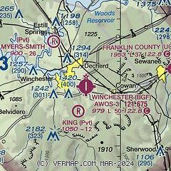
|
| Airport distance calculator |
|---|
|
|
| Sunrise and sunset |
|---|
|
Times for 03-May-2026
| | Local
(UTC-5) | | Zulu
(UTC) |
|---|
| Morning civil twilight | | 05:25 | | 10:25 |
| Sunrise | | 05:52 | | 10:52 |
| Sunset | | 19:30 | | 00:30 |
| Evening civil twilight | | 19:58 | | 00:58 |
|
| Current date and time |
|---|
| Zulu (UTC) | 03-May-2026 13:49:00 |
|---|
| Local (UTC-5) | 03-May-2026 08:49:00 |
|---|
|
| METAR |
|---|
| KBGF | 031335Z AUTO 00000KT 10SM FEW008 10/09 A3018 RMK A01
|
|
| NOTAMs |
|---|
NOTAMs are issued by the DoD/FAA and will open in a separate window not controlled by AirNav.
|
|


