FAA INFORMATION EFFECTIVE 14 MAY 2026
Location
| FAA Identifier: | FYM |
| Lat/Long: | 35-03-34.9000N 086-33-50.4000W
35-03.581667N 086-33.840000W
35.0596944,-86.5640000
(estimated) |
| Elevation: | 983.9 ft. / 299.9 m (surveyed) |
| Variation: | 01W (1990) |
| From city: | 6 miles S of FAYETTEVILLE, TN |
| Time zone: | UTC -5 (UTC -6 during Standard Time) |
| Zip code: | 37334 |
Airport Operations
| Airport use: | Open to the public |
| Control tower: | no |
| ARTCC: | MEMPHIS CENTER |
| FSS: | JACKSON FLIGHT SERVICE STATION |
| NOTAMs facility: | MKL (NOTAM-D service available) |
| Attendance: | MON-FRI 0800-1630
CLSD CHRISTMAS, 4TH JULY, LABOR DAY AND EASTER. |
| Wind indicator: | lighted |
| Segmented circle: | yes |
| Lights: | ACTVT ODALS RWY 20; REIL RWY 02 & 20 - CTAF. PAPI RWY 02 & 20 OPR CONSLY. MIRL RWY 02/20 OPR DUSK-DAWN. |
| Beacon: | white-green (lighted land airport)
Operates sunset to sunrise. |
Airport Communications
| CTAF/UNICOM: | 122.8 |
| WX AWOS-3: | 135.275 (931-433-5916) |
| HUNTSVILLE APPROACH: | 125.6 [0600-2350] |
| HUNTSVILLE DEPARTURE: | 125.6 [0600-2350] |
| WX AWOS-3PT at MDQ (12 nm S): | 120.000 (256-829-1242) |
- APCH/DEP SVC PRVDD BY MEMPHIS ARTCC ON FREQS 120.8/307.0 (HUNTSVILLE RCAG) WHEN HUNTSVILLE APCH CTL CLSD.
Nearby radio navigation aids
| VOR radial/distance | | VOR name | | Freq | | Var |
|---|
| RQZr010/16.1 | | ROCKET VORTAC | | 112.20 | | 02E |
| SYIr192/30.8 | | SHELBYVILLE VOR/DME | | 113.55 | | 01W |
Airport Services
| Fuel available: | 100LL JET-A |
| Parking: | hangars and tiedowns |
| Airframe service: | MAJOR |
| Powerplant service: | MAJOR |
| Bottled oxygen: | HIGH/LOW |
| Bulk oxygen: | NONE |
Runway Information
Runway 2/20
| Dimensions: | 5900 x 100 ft. / 1798 x 30 m |
| Surface: | asphalt, in good condition |
| Weight bearing capacity: | | Single wheel: | 21.0 | | Double wheel: | 31.0 |
|
| Runway edge lights: | medium intensity |
| RUNWAY 2 | | RUNWAY 20 |
| Latitude: | 35-03.109870N | | 35-04.054133N |
| Longitude: | 086-33.982165W | | 086-33.699057W |
| Elevation: | 959.6 ft. | | 983.3 ft. |
| Traffic pattern: | left | | left |
| Runway heading: | 015 magnetic, 014 true | | 195 magnetic, 194 true |
| Displaced threshold: | 400 ft. | | no |
| Declared distances: | TORA:5900 TODA:5900 ASDA:5900 LDA:5500 | | TORA:5900 ASDA:5900 LDA:5900 |
| Markings: | nonprecision, in good condition | | nonprecision, in good condition |
| Visual slope indicator: | 4-light PAPI on left (3.00 degrees glide path) | | 4-light PAPI on left (3.00 degrees glide path) |
| Approach lights: | | | ODALS: omnidirectional approach lighting system |
| Runway end identifier lights: | yes | | yes |
| Touchdown point: | yes, no lights | | yes, no lights |
| Instrument approach: | | | SDF |
| Obstructions: | 82 ft. trees, 1965 ft. from runway, 488 ft. right of centerline, 21:1 slope to clear
APCH RATIO 33:1 TO DSPLCD THR. | | 88 ft. trees, 2286 ft. from runway, 321 ft. left of centerline, 23:1 slope to clear |
Airport Ownership and Management from official FAA records
| Ownership: | Publicly-owned |
| Owner: | FAYETTEVILLE-LINCOLN ARPT AUTH
37 AIRPORT ROAD
FAYETTEVILLE, TN 37334
Phone 931-433-1960
FAYETTEVILLE-LINCOLN COUNTY REGIONAL AIRPORT AUTHORITY. |
| Manager: | MARK COBB
37 AIRPORT RD
FAYETTEVILLE, TN 37334
Phone 931-433-1960 |
Additional Remarks
| - | FOR CD CTC HUNTSVILLE APCH ON GCO FREQ, IF UNA ON FREQ, CTC HUNTSVILLE APCH AT 256-542-2097, WHEN APCH CLSD CTC MEMPHIS ARTCC AT 901-368-8453/8449. |
| - | GCO AVBL ON FREQ 121.725, 4 CLICKS. |
Instrument Procedures
NOTE: All procedures below are presented as PDF files. If you need a reader for these files, you should download the free Adobe Reader.NOT FOR NAVIGATION. Please procure official charts for flight.
FAA instrument procedures published for use from 14 May 2026 at 0901Z to 11 June 2026 at 0900Z.
IAPs - Instrument Approach Procedures |
|---|
| RNAV (GPS) RWY 02 **CHANGED** | |
download (263KB) |
| RNAV (GPS) RWY 20 **CHANGED** | |
download (289KB) |
| VOR/DME RWY 02 **CHANGED** | |
download (214KB) |
| NOTE: Special Take-Off Minimums/Departure Procedures apply | |
download (126KB) |
Other nearby airports with instrument procedures:
KMDQ - Huntsville Executive Airport / Tom Sharp Jr Field (12 nm S)
KHUA - Redstone Army Airfield (24 nm S)
KTHA - Tullahoma Regional Airport/William Northern Field (25 nm NE)
KGZS - Abernathy Field Airport (25 nm W)
KBGF - Winchester Municipal Airport (25 nm E)
|
|

Road maps at:
MapQuest
Bing
Google
| Aerial photo |
|---|
WARNING: Photo may not be current or correct
 Photo courtesy of SellersPhoto.com
Photo taken 01-Apr-2014
looking north.
Photo courtesy of SellersPhoto.com
Photo taken 01-Apr-2014
looking north.
Do you have a better or more recent aerial photo of Fayetteville Municipal Airport that you would like to share? If so, please send us your photo.
|
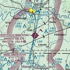
| Sectional chart |
|---|
|
| Airport distance calculator |
|---|
|
|
| Sunrise and sunset |
|---|
|
Times for 22-May-2026
| | Local
(UTC-5) | | Zulu
(UTC) |
|---|
| Morning civil twilight | | 05:10 | | 10:10 |
| Sunrise | | 05:39 | | 10:39 |
| Sunset | | 19:47 | | 00:47 |
| Evening civil twilight | | 20:16 | | 01:16 |
|
| Current date and time |
|---|
| Zulu (UTC) | 23-May-2026 01:30:47 |
|---|
| Local (UTC-5) | 22-May-2026 20:30:47 |
|---|
|
| METAR |
|---|
| KFYM | 230115Z AUTO 19009G16KT 10SM FEW021 BKN029 BKN035 22/21 A2995 RMK A01
|
KMDQ
12nm S | 230115Z AUTO 16005KT 10SM SCT021 22/20 A2995 RMK A02 T02240203
|
|
| NOTAMs |
|---|
NOTAMs are issued by the DoD/FAA and will open in a separate window not controlled by AirNav.
|
|

