FAA INFORMATION EFFECTIVE 16 APRIL 2026
Location
| FAA Identifier: | BVX |
| Lat/Long: | 35-43-34.4000N 091-38-50.8000W
35-43.573333N 091-38.846667W
35.7262222,-91.6474444
(estimated) |
| Elevation: | 465 ft. / 141.7 m (surveyed) |
| Variation: | 01E (2005) |
| From city: | 3 miles S of BATESVILLE, AR |
| Time zone: | UTC -5 (UTC -6 during Standard Time) |
| Zip code: | 72501 |
Airport Operations
| Airport use: | Open to the public |
| Activation date: | 12/1944 |
| Control tower: | no |
| ARTCC: | MEMPHIS CENTER |
| FSS: | JONESBORO FLIGHT SERVICE STATION |
| NOTAMs facility: | BVX (NOTAM-D service available) |
| Attendance: | 0730-1730, ALL 1730-0730
CALL OUT FEE APPLIES |
| Pattern altitude: | 1250 ft. MSL |
| Wind indicator: | lighted |
| Segmented circle: | yes |
| Lights: | ACTVT REIL RWYS 08 & 26 AND MIRL RWY 08/26 - CTAF. |
| Beacon: | white-green (lighted land airport)
Operates sunset to sunrise. |
Airport Communications
| CTAF/UNICOM: | 122.8 |
| WX AWOS-3PT: | 126.375 (870-251-1369) |
- APCH/DEP SVC PRVDD BY MEMPHIS ARTCC ON FREQS 126.85/281.55 (BRINKLEY RCAG).
Airport Services
| Fuel available: | 100LL JET-A+
100LL:100LL SELF SVC AVBL WITH CREDIT CARD. FOR SVC AFTER HRS CALL 870-251-1244, FEE CHRGD.
A+:JET A+ SELF SERVE UNAVAILABLE |
| Parking: | hangars and tiedowns |
| Airframe service: | MAJOR |
| Powerplant service: | MAJOR |
| Bottled oxygen: | NONE |
| Bulk oxygen: | NONE |
Runway Information
Runway 8/26
| Dimensions: | 6002 x 150 ft. / 1829 x 46 m |
| Surface: | asphalt, in fair condition |
| Weight bearing capacity: | | Single wheel: | 30.0, (S) TAXIWAYS LIMITED TO 31K - APRONS LIMITED TO 29K | | Double wheel: | 105.0, (D) TAXIWAYS LIMITED TO 77K - APRONS LIMITED TO 67K | | Double tandem: | 195.0, (2D) TAXIWAYS LIMITED TO 204K - APRONS LIMITED TO 184K |
|
| Runway edge lights: | medium intensity |
| RUNWAY 8 | | RUNWAY 26 |
| Latitude: | 35-43.384212N | | 35-43.559343N |
| Longitude: | 091-39.667855W | | 091-38.473847W |
| Elevation: | 452.2 ft. | | 464.6 ft. |
| Traffic pattern: | left | | left |
| Runway heading: | 079 magnetic, 080 true | | 259 magnetic, 260 true |
| Markings: | nonprecision, in good condition | | nonprecision, in good condition |
| Visual slope indicator: | 2-light PAPI on left (3.00 degrees glide path) | | 2-light PAPI on left (3.00 degrees glide path) |
| Runway end identifier lights: | yes | | yes |
| Touchdown point: | yes, no lights | | yes, no lights |
| Instrument approach: | LOC/DME | | |
| Obstructions: | none | | 32 ft. tree, 1320 ft. from runway, 35:1 slope to clear |
Runway 18/36
| Dimensions: | 2804 x 60 ft. / 855 x 18 m |
| Surface: | asphalt, in good condition |
| Weight bearing capacity: | | Single wheel: | 30.0, (S) TAXIWAYS LIMITED TO 31K - APRONS LIMITED TO 29K | | Double wheel: | 105.0, (D) TAXIWAYS LIMITED TO 77K - APRONS LIMITED TO 67K |
|
| RUNWAY 18 | | RUNWAY 36 |
| Latitude: | 35-44.019115N | | 35-43.557073N |
| Longitude: | 091-38.364773W | | 091-38.374532W |
| Elevation: | 435.4 ft. | | 460.4 ft. |
| Traffic pattern: | left | | left |
| Runway heading: | 180 magnetic, 181 true | | 000 magnetic, 001 true |
| Markings: | basic, in good condition | | basic, in good condition |
| Touchdown point: | yes, no lights | | yes, no lights |
| Obstructions: | 45 ft. tree, 800 ft. from runway, 180 ft. right of centerline, 13:1 slope to clear | | 10 ft. road, 275 ft. from runway, 7:1 slope to clear |
Airport Ownership and Management from official FAA records
| Ownership: | Publicly-owned |
| Owner: | CITY OF BATESVILLE
500 EAST MAIN ST.
BATESVILLE, AR 72501
Phone 870-698-2400 |
| Manager: | JUSTIN THOMPSON
1126 BATESVILLE BLVD
BATESVILLE, AR 72501
Phone 870-251-1244 |
Additional Remarks
| - | FOR CD CTC MEMPHIS ARTCC AT 901-368-8453/8449. |
Instrument Procedures
NOTE: All procedures below are presented as PDF files. If you need a reader for these files, you should download the free Adobe Reader.NOT FOR NAVIGATION. Please procure official charts for flight.
FAA instrument procedures published for use from 16 April 2026 at 0901Z to 14 May 2026 at 0900Z.
IAPs - Instrument Approach Procedures |
|---|
| RNAV (GPS) RWY 08 | |
download (234KB) |
| RNAV (GPS) RWY 26 | |
download (240KB) |
| LOC RWY 08 | |
download (241KB) |
| NOTE: Special Alternate Minimums apply | |
download (122KB) |
| NOTE: Special Take-Off Minimums/Departure Procedures apply | |
download (426KB) |
Other nearby airports with instrument procedures:
KHBZ - Heber Springs Municipal Airport (22 nm SW)
42A - Melbourne Municipal Airport/John E Miller Field (23 nm NW)
7M2 - Mountain View Airport-Wilcox Memorial Field (23 nm W)
M19 - Newport Regional Airport (24 nm E)
6M2 - Horseshoe Bend Airport (30 nm N)
|
|

Road maps at:
MapQuest
Bing
Google
| Aerial photo |
|---|
WARNING: Photo may not be current or correct
 Photo courtesy of the Arkansas Department of Aeronautics
Taken in the Spring of 2007
Photo courtesy of the Arkansas Department of Aeronautics
Taken in the Spring of 2007
Do you have a better or more recent aerial photo of Batesville Regional Airport that you would like to share? If so, please send us your photo.
|
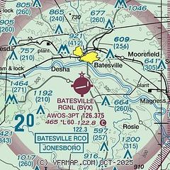
| Sectional chart |
|---|
|
| Airport distance calculator |
|---|
|
|
| Sunrise and sunset |
|---|
|
Times for 30-Apr-2026
| | Local
(UTC-5) | | Zulu
(UTC) |
|---|
| Morning civil twilight | | 05:49 | | 10:49 |
| Sunrise | | 06:17 | | 11:17 |
| Sunset | | 19:51 | | 00:51 |
| Evening civil twilight | | 20:18 | | 01:18 |
|
| Current date and time |
|---|
| Zulu (UTC) | 30-Apr-2026 08:14:44 |
|---|
| Local (UTC-5) | 30-Apr-2026 03:14:44 |
|---|
|
| METAR |
|---|
| KBVX | 300756Z AUTO VRB03KT 10SM CLR 13/07 A3005 RMK AO2 SLP175 T01280072 $
|
|
| TAF |
|---|
KJBR
49nm E | 300520Z 3006/0106 03008KT P6SM BKN150 FM301300 06008KT P6SM SCT150 FM010000 VRB03KT P6SM SKC
|
|
| NOTAMs |
|---|
NOTAMs are issued by the DoD/FAA and will open in a separate window not controlled by AirNav.
|
|

