FAA INFORMATION EFFECTIVE 16 APRIL 2026
Location
| FAA Identifier: | 7M2 |
| Lat/Long: | 35-51-52.1290N 092-05-25.2190W
35-51.868817N 092-05.420317W
35.8644803,-92.0903386
(estimated) |
| Elevation: | 805 ft. / 245 m (estimated) |
| Variation: | 01E (2010) |
| From city: | 2 miles E of MOUNTAIN VIEW, AR |
| Time zone: | UTC -5 (UTC -6 during Standard Time) |
| Zip code: | 72560 |
Airport Operations
| Airport use: | Open to the public |
| Activation date: | 12/1959 |
| Control tower: | no |
| ARTCC: | MEMPHIS CENTER |
| FSS: | JONESBORO FLIGHT SERVICE STATION |
| NOTAMs facility: | JBR (NOTAM-D service available) |
| Attendance: | UNATNDD
FOR SVC AFT HRS CALL 501-203-8644. |
| Wind indicator: | lighted |
| Segmented circle: | no |
| Lights: | MIRL RWY 09/27 -CTAF (3 - LOW, 5- MED, 7 - HIGH) |
| Beacon: | white-green (lighted land airport)
Operates sunset to sunrise. |
| Taxiway lights: | TWY EXIT LIGHT AT END RWY 09. |
Airport Communications
| CTAF/UNICOM: | 122.7 |
| WX AWOS-3PT at 42A (18 nm NE): | 121.575 (870-916-2768) |
- APCH/DEP SVC PRVDD BY MEMPHIS ARTCC ON FREQS 126.85/281.55(HARRISON RCAG).
Airport Services
| Fuel available: | 100LL
100LL:SELF-SERVICE FUEL AVBL 24 HRS WITH CREDIT CARD. |
| Parking: | hangars and tiedowns |
| Airframe service: | NONE |
| Powerplant service: | NONE |
| Bottled oxygen: | NONE |
Runway Information
Runway 9/27
| Dimensions: | 4502 x 70 ft. / 1372 x 21 m |
| Surface: | asphalt, in fair condition |
| Runway edge lights: | medium intensity |
| RUNWAY 9 | | RUNWAY 27 |
| Latitude: | 35-51.885333N | | 35-51.852267N |
| Longitude: | 092-05.875667W | | 092-04.964933W |
| Elevation: | 804.0 ft. | | 780.0 ft. |
| Traffic pattern: | left | | left |
| Runway heading: | 092 magnetic, 093 true | | 272 magnetic, 273 true |
| Markings: | nonprecision, in fair condition | | nonprecision, in fair condition |
| Touchdown point: | yes, no lights | | yes, no lights |
| Obstructions: | 21 ft. bldg, 435 ft. from runway, 110 ft. right of centerline, 11:1 slope to clear | | 355 ft. tower, lighted, 5280 ft. from runway, 14:1 slope to clear
6-8 FT BRUSH APRX 50 FT FM RWY END. |
Airport Ownership and Management from official FAA records
| Ownership: | Publicly-owned |
| Owner: | CITY OF MOUNTAIN VIEW
CITY HALL
MOUNTAIN VIEW, AR 72560
Phone 870-269-3804 |
| Manager: | LARRY SNYDER
1501 AIRPORT LANE
MOUNTAIN VIEW, AR 72560
Phone 501-203-8644 |
Additional Remarks
| - | RY 27 HAS A 15 FT DROPOFF 400 FT FM THLD. |
| - | DEER & COYOTES ON & INVOF ARPT. |
| - | FOR CD CTC MEMPHIS ARTCC AT 901-368-8453/8449. |
| - | (TDZ ELEV SOURCE, RWY 09) FTW FPO. |
| - | (TDZ ELEV SOURCE, RWY 27) FTW FPO. |
Instrument Procedures
NOTE: All procedures below are presented as PDF files. If you need a reader for these files, you should download the free Adobe Reader.NOT FOR NAVIGATION. Please procure official charts for flight.
FAA instrument procedures published for use from 16 April 2026 at 0901Z to 14 May 2026 at 0900Z.
IAPs - Instrument Approach Procedures |
|---|
| RNAV (GPS) RWY 27 | |
download (199KB) |
| NOTE: Special Take-Off Minimums/Departure Procedures apply | |
download (390KB) |
Other nearby airports with instrument procedures:
42A - Melbourne Municipal Airport/John E Miller Field (18 nm NE)
2A2 - Holley Mountain Airpark (20 nm SW)
KHBZ - Heber Springs Municipal Airport (22 nm S)
KBVX - Batesville Regional Airport (23 nm E)
KCCA - Clinton Municipal Airport (24 nm SW)
|
|

Road maps at:
MapQuest
Bing
Google
| Aerial photo |
|---|
WARNING: Photo may not be current or correct
 Photo taken 05-Aug-2012
looking northeast.
Photo taken 05-Aug-2012
looking northeast.
Do you have a better or more recent aerial photo of Mountain View Airport-Wilcox Memorial Field that you would like to share? If so, please send us your photo.
|
| Sectional chart |
|---|
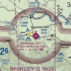
|
| Airport distance calculator |
|---|
|
|
| Sunrise and sunset |
|---|
|
Times for 25-Apr-2026
| | Local
(UTC-5) | | Zulu
(UTC) |
|---|
| Morning civil twilight | | 05:57 | | 10:57 |
| Sunrise | | 06:24 | | 11:24 |
| Sunset | | 19:49 | | 00:49 |
| Evening civil twilight | | 20:16 | | 01:16 |
|
| Current date and time |
|---|
| Zulu (UTC) | 25-Apr-2026 16:40:49 |
|---|
| Local (UTC-5) | 25-Apr-2026 11:40:49 |
|---|
|
| METAR |
|---|
KBVX
23nm E | 251624Z AUTO 00000KT 10SM BKN021 BKN031 20/17 A2989 RMK AO2 $
|
KCCA
24nm SW | 251615Z AUTO VRB04KT 10SM OVC022 20/16 A2988 RMK AO2
|
KBPK
35nm NW | 251553Z AUTO 15007KT 10SM BKN016 20/16 A2987 RMK AO2 SLP108 T02000161 PWINO
|
KSRC
41nm SE | 251556Z AUTO 09008KT 10SM OVC011 18/17 A2988 RMK AO2 SLP116 T01830172 $
|
|
| TAF |
|---|
KBPK
35nm NW | 251525Z 2515/2612 13009KT P6SM SCT008 OVC016 FM251600 15007KT P6SM OVC015 FM251800 15006KT P6SM BKN250 FM260300 13006KT P6SM -SHRA OVC050
|
|
| NOTAMs |
|---|
NOTAMs are issued by the DoD/FAA and will open in a separate window not controlled by AirNav.
|
|

