FAA INFORMATION EFFECTIVE 16 APRIL 2026
Location
| FAA Identifier: | CAK |
| Lat/Long: | 40-54-54.2000N 081-26-37.1000W
40-54.903333N 081-26.618333W
40.9150556,-81.4436389
(estimated) |
| Elevation: | 1225.5 ft. / 373.5 m (surveyed) |
| Variation: | 07W (1985) |
| From city: | 10 miles SE of AKRON, OH |
| Time zone: | UTC -4 (UTC -5 during Standard Time) |
| Zip code: | 44720 |
Airport Operations
| Airport use: | Open to the public |
| Control tower: | yes |
| ARTCC: | CLEVELAND CENTER |
| FSS: | CLEVELAND FLIGHT SERVICE STATION |
| NOTAMs facility: | CAK (NOTAM-D service available) |
| Attendance: | CONTINUOUS |
| Wind indicator: | lighted |
| Segmented circle: | no |
| Beacon: | white-green (lighted land airport)
Operates sunset to sunrise. |
| Landing fee: | yes, MULTI ENG ONLY |
| Fire and rescue: | ARFF index B |
| Airline operations: | ARFF SVC NOT AVBL 0100-0500 LCL DLY. ONE HOUR PPR FOR UNSKED ACR OPNS; CALL AMGR 330-499-4059. |
| International operations: | customs landing rights airport |
Airport Communications
| UNICOM: | 122.95 |
| ATIS: | 121.05 |
| WX ASOS: | PHONE 330-227-8682 |
| AKRON-CANTON GROUND: | 121.7 348.6 |
| AKRON-CANTON TOWER: | 134.75 279.575 |
| CLEVELAND APPROACH: | 118.6 ;187-006 125.5 ;007-186 |
| CLEVELAND DEPARTURE: | 118.6 ;187-006 125.5 ;007-186 |
| CLEARANCE DELIVERY: | 132.05 |
| ARNG OPS: | 138.55 226.9 40.1FM |
| BRWNZ STAR: | 126.55 |
| CLASS C: | 118.6 ;187-006 125.5 ;007-186 |
| EMERG: | 121.5 243.0 |
| HUUVR STAR: | 125.5 |
| IC: | 125.5 ;007-186 |
| ZZIPS STAR: | 125.5 |
| WX ASOS at AKR (7 nm N): | 126.825 (330-724-4237) |
| WX AWOS-2 at 1G3 (14 nm N): | 119.15 (330-346-1497) |
| WX AWOS-3 at POV (20 nm NE): | 118.675 (330-298-9353) |
- APCH/DEP SVC PRVDD BY CLEVELAND APCH (CLE) 0600-0100. APCH/DEP SVC PRVDD BY CLEVELAND ARTCC (ZOB) ON FREQS 134.9/269.475 (MANSFIELD RCAG) 0100-0600.
Nearby radio navigation aids
| VOR radial/distance | | VOR name | | Freq | | Var |
|---|
| BSVr001/10.5 | | BRIGGS VOR/DME | | 114.05 | | 04W |
| ACOr227/15.9 | | AKRON VOR/DME | | 114.40 | | 04W |
| NDB name | | Hdg/Dist | | Freq | | Var | | ID |
|---|
| AKRON | | 202/9.6 | | 362 | | 07W | | AK | .- -.- |
Airport Services
| Fuel available: | 100LL JET-A |
| Parking: | hangars and tiedowns |
| Airframe service: | MAJOR |
| Powerplant service: | MAJOR |
| Bottled oxygen: | NONE |
| Bulk oxygen: | HIGH/LOW |
Runway Information
Runway 5/23
| Dimensions: | 8204 x 150 ft. / 2501 x 46 m |
| Surface: | asphalt/grooved, in good condition |
| Weight bearing capacity: | | Single wheel: | 120.0 | | Double wheel: | 160.0 | | Double tandem: | 250.0 |
|
| Runway edge lights: | high intensity |
| RUNWAY 5 | | RUNWAY 23 |
| Latitude: | 40-54.304893N | | 40-55.218118N |
| Longitude: | 081-27.433615W | | 081-26.121390W |
| Elevation: | 1179.6 ft. | | 1225.5 ft. |
| Traffic pattern: | left | | left |
| Runway heading: | 054 magnetic, 047 true | | 234 magnetic, 227 true |
| Declared distances: | TORA:8204 TODA:8204 ASDA:8204 LDA:8204 | | TORA:8204 TODA:8204 ASDA:8204 LDA:8204 |
| Markings: | precision, in good condition | | precision, in good condition |
| Visual slope indicator: | 4-light PAPI on left (3.00 degrees glide path) | | 4-light PAPI on left (3.00 degrees glide path) |
| RVR equipment: | touchdown, rollout | | touchdown, rollout |
| Approach lights: | MALSR: 1,400 foot medium intensity approach lighting system with runway alignment indicator lights | | MALSR: 1,400 foot medium intensity approach lighting system with runway alignment indicator lights |
| Runway end identifier lights: | no | | no |
| Touchdown point: | yes, no lights | | yes, no lights |
| Instrument approach: | ILS/DME | | ILS/DME |
Runway 1/19
| Dimensions: | 7601 x 150 ft. / 2317 x 46 m |
| Surface: | asphalt/grooved, in good condition |
| Weight bearing capacity: | | Single wheel: | 120.0 | | Double wheel: | 160.0 | | Double tandem: | 250.0 |
|
| Runway edge lights: | high intensity |
| RUNWAY 1 | | RUNWAY 19 |
| Latitude: | 40-54.430087N | | 40-55.680565N |
| Longitude: | 081-26.481623W | | 081-26.410305W |
| Elevation: | 1208.6 ft. | | 1214.0 ft. |
| Traffic pattern: | left | | left |
| Runway heading: | 009 magnetic, 002 true | | 189 magnetic, 182 true |
| Displaced threshold: | no | | 601 ft. |
| Declared distances: | TORA:7601 TODA:7601 ASDA:7007 LDA:7007 | | TORA:7601 TODA:7601 ASDA:7601 LDA:7007 |
| Markings: | precision, in good condition | | precision, in good condition |
| Visual slope indicator: | | | 4-light PAPI on left (3.00 degrees glide path) |
| RVR equipment: | touchdown, rollout | | touchdown, rollout |
| Approach lights: | MALSR: 1,400 foot medium intensity approach lighting system with runway alignment indicator lights | | MALSR: 1,400 foot medium intensity approach lighting system with runway alignment indicator lights |
| Runway end identifier lights: | no | | no |
| Touchdown point: | yes, no lights | | yes, no lights |
| Instrument approach: | ILS | | ILS |
Airport Ownership and Management from official FAA records
| Ownership: | Publicly-owned |
| Owner: | AKRON CANTON RGNL ARPT AUTHORITY
5400 LAUBY RD
NORTH CANTON, OH 44720
Phone 330-499-4059 |
| Manager: | RENATO CAMACHO
5400 LAUBY RD
NORTH CANTON, OH 44720
Phone 330-754-5233 |
Additional Remarks
| A39-05/23 | PCR VALUE: 410/F/B/X/U |
| A39-01/19 | PCR VALUE: 410/F/B/X/U |
| - | DEER & BIRDS ON & INVOF ARPT. |
| - | ALL ACFT TAXIING ON AIR CAMIS RAMP & NORTH HANGAR AREAS NOT VISIBLE FM ATCT. |
| - | TWY E EAST OF TWY B CLSD TO ACFT OVER 118 FT WINGSPAN. |
| - | FOR CD CTC CLEVELAND ARTCC AT 440-774-0223. |
Instrument Procedures
NOTE: All procedures below are presented as PDF files. If you need a reader for these files, you should download the free Adobe Reader.NOT FOR NAVIGATION. Please procure official charts for flight.
FAA instrument procedures published for use from 16 April 2026 at 0901Z to 14 May 2026 at 0900Z.
STARs - Standard Terminal Arrivals |
|---|
| BRWNZ FOUR (RNAV) | |
2 pages:
[1] [2] (449KB) |
| BRWNZ FOUR (RNAV), CONT.2 | |
download (235KB) |
| HUUVR ONE (RNAV) | |
download (169KB) |
| ZZIPS ONE (RNAV) | |
download (149KB) |
IAPs - Instrument Approach Procedures |
|---|
| ILS OR LOC RWY 01 | |
download (226KB) |
| ILS OR LOC RWY 05 | |
download (241KB) |
| ILS OR LOC RWY 19 | |
download (301KB) |
| ILS OR LOC RWY 23 | |
download (287KB) |
| RNAV (GPS) RWY 01 | |
download (233KB) |
| RNAV (GPS) RWY 05 | |
download (230KB) |
| RNAV (GPS) RWY 19 | |
download (232KB) |
| RNAV (GPS) RWY 23 | |
download (243KB) |
| VOR RWY 05 | |
download (218KB) |
| VOR RWY 23 | |
download (209KB) |
| NOTE: Special Take-Off Minimums/Departure Procedures apply | |
download (164KB) |
Other nearby airports with instrument procedures:
KAKR - Akron Fulton International Airport (7 nm N)
1G3 - Kent State University Airport (14 nm N)
3G3 - Wadsworth Municipal Airport (15 nm W)
1G5 - Medina Municipal Airport (19 nm NW)
KPOV - Portage County Airport (20 nm NE)
|
|

Road maps at:
MapQuest
Bing
Google
| Aerial photo |
|---|
WARNING: Photo may not be current or correct
 Photo by Ron Haydu
Photo taken 20-Sep-2018
looking south.
Photo by Ron Haydu
Photo taken 20-Sep-2018
looking south.
Do you have a better or more recent aerial photo of Akron-Canton Regional Airport that you would like to share? If so, please send us your photo.
|
| Sectional chart |
|---|
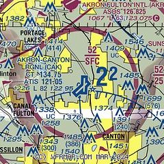
|
CAUTION: Diagram may not be current
 Download PDF
of official airport diagram from the FAA
| Airport distance calculator |
|---|
|
|
| Sunrise and sunset |
|---|
|
Times for 24-Apr-2026
| | Local
(UTC-4) | | Zulu
(UTC) |
|---|
| Morning civil twilight | | 06:05 | | 10:05 |
| Sunrise | | 06:34 | | 10:34 |
| Sunset | | 20:13 | | 00:13 |
| Evening civil twilight | | 20:43 | | 00:43 |
|
| Current date and time |
|---|
| Zulu (UTC) | 24-Apr-2026 16:56:16 |
|---|
| Local (UTC-4) | 24-Apr-2026 12:56:16 |
|---|
|
| METAR |
|---|
| KCAK | 241551Z 26005KT 10SM FEW090 BKN250 24/12 A2983 RMK AO2 SLP092 T02390122
|
KAKR
7nm N | 241554Z AUTO 25006KT 10SM CLR 24/13 A2980 RMK AO2 SLP086 T02440128
|
KPOV
20nm NE | 241635Z AUTO 27008KT 10SM SCT070 SCT080 25/09 A2981 RMK AO2 T02510087
|
|
| TAF |
|---|
| KCAK | 241120Z 2412/2512 VRB04KT P6SM FEW100 FM241500 25010KT P6SM OVC120 PROB30 2500/2504 4SM -TSRA OVC035CB FM250400 23005KT P6SM -RA VCTS OVC035CB FM250800 23005KT 5SM BR VCSH BKN008
|
|
| NOTAMs |
|---|
NOTAMs are issued by the DoD/FAA and will open in a separate window not controlled by AirNav.
|
|


