FAA INFORMATION EFFECTIVE 14 MAY 2026
Location
| FAA Identifier: | DZJ |
| Lat/Long: | 34-51-15.9530N 083-59-50.3520W
34-51.265883N 083-59.839200W
34.8544314,-83.9973200
(estimated) |
| Elevation: | 1906.9 ft. / 581.2 m (surveyed) |
| Variation: | 03W (1985) |
| From city: | 3 miles SW of BLAIRSVILLE, GA |
| Time zone: | UTC -4 (UTC -5 during Standard Time) |
| Zip code: | 30512 |
Airport Operations
| Airport use: | Open to the public |
| Control tower: | no |
| ARTCC: | ATLANTA CENTER |
| FSS: | MACON FLIGHT SERVICE STATION |
| NOTAMs facility: | MCN (NOTAM-D service available) |
| Attendance: | 0800-1700 |
| Wind indicator: | lighted |
| Segmented circle: | yes |
| Lights: | ACTVT PAPI RWY 08 & 26; MIRL RWY 08/26 - CTAF. |
| Beacon: | white-green (lighted land airport)
Operates sunset to sunrise. |
Airport Communications
| CTAF/UNICOM: | 122.8 |
| WX AWOS-3PT: | 119.325 (706-745-9271) |
- APCH/DEP SVC PRVDD BY ATLANTA ARTCC (ZTL) ON FREQS 134.8/379.95 (MOUNT OGLETHORPE RCAG).
Nearby radio navigation aids
| VOR radial/distance | | VOR name | | Freq | | Var |
|---|
| ODFr285/35.8 | | FOOTHILLS VOR/DME | | 113.40 | | 00E |
Airport Services
| Fuel available: | 100LL JET-A+
100LL:LCTD ON NORTH SIDE OF RWY.
A+:AVBL DRG OPRG HOURS 0800 TO 1800. |
| Parking: | tiedowns |
| Airframe service: | NONE |
| Powerplant service: | NONE |
| Bottled oxygen: | NONE |
| Bulk oxygen: | NONE |
Runway Information
Runway 8/26
| Dimensions: | 5004 x 100 ft. / 1525 x 30 m |
| Surface: | asphalt, in fair condition |
| Weight bearing capacity: | | Single wheel: | 20.0 | | Double wheel: | 39.0 |
|
| Runway edge lights: | medium intensity |
| Operational restrictions: | RWY SLPS DOWNHILL 1.5 PCT EAST. |
| RUNWAY 8 | | RUNWAY 26 |
| Latitude: | 34-51.146480N | | 34-51.385253N |
| Longitude: | 084-00.318078W | | 083-59.360290W |
| Elevation: | 1906.9 ft. | | 1855.3 ft. |
| Traffic pattern: | left | | left |
| Runway heading: | 076 magnetic, 073 true | | 256 magnetic, 253 true |
| Displaced threshold: | 987 ft. | | 685 ft. |
| Declared distances: | TORA:5004 TODA:5004 ASDA:5004 LDA:4017 | | TORA:5004 TODA:5004 ASDA:5004 LDA:4319 |
| Markings: | nonprecision, in good condition | | nonprecision, in good condition |
| Visual slope indicator: | 2-light PAPI on left (3.31 degrees glide path) | | 2-light PAPI on left (3.54 degrees glide path)
UNUSBL BYD 1.3 NM DUE TO TRRN. |
| Touchdown point: | yes, no lights | | yes, no lights |
| Obstructions: | 67 ft. trees, 507 ft. from runway, 291 ft. left of centerline, 4:1 slope to clear
APCH RATIO 15:1 TO DSPLCD THR; 177 FT TREES 2653 FT FM DSPLCD THR 451 FT LEFT. | | 30 ft. trees, 201 ft. from runway, 155 ft. left of centerline
RWY 26 +10 FT-13 FT HILL 135 FT-250 FT L&R, 20 FT TREES 147 FT LEFT 0 FT-200 FT FM END OF RWY. |
Airport Ownership and Management from official FAA records
| Ownership: | Publicly-owned |
| Owner: | CITY OF BLAIRSVILLE
P.O. BOX 307, 62 BLUE RIDGE STREET, 33 BLUERIDGE STREET
BLAIRSVILLE, GA 30512
Phone 706-745-2000 |
| Manager: | DAN FIREBAUGH
579 AIRPORT TERMINAL DRIVE
BLAIRSVILLE, GA 30512
Phone 706-745-4307 |
Additional Remarks
| - | WILDLIFE INCLG DEER AND GEESE, INVOF RWYS AND TWYS. |
| - | FOR CD CTC ATLANTA ARTCC AT 770-210-7692. |
Instrument Procedures
NOTE: All procedures below are presented as PDF files. If you need a reader for these files, you should download the free Adobe Reader.NOT FOR NAVIGATION. Please procure official charts for flight.
FAA instrument procedures published for use from 14 May 2026 at 0901Z to 11 June 2026 at 0900Z.
IAPs - Instrument Approach Procedures |
|---|
| RNAV (GPS) RWY 08 | |
download (203KB) |
| NOTE: Special Alternate Minimums apply | |
download (159KB) |
| NOTE: Special Take-Off Minimums/Departure Procedures apply | |
download (509KB) |
Other nearby airports with instrument procedures:
1A3 - Martin Campbell Field Airport (20 nm NW)
KRHP - Western Carolina Regional Airport (21 nm N)
49A - Gilmer County Airport (29 nm SW)
KAJR - Habersham County Airport (30 nm SE)
KJZP - Pickens County Airport (33 nm SW)
|
|

Road maps at:
MapQuest
Bing
Google
| Aerial photo |
|---|
WARNING: Photo may not be current or correct
 Photo courtesy of AirNav, LLC
Photo taken 21-Jul-2010
Photo courtesy of AirNav, LLC
Photo taken 21-Jul-2010
Do you have a better or more recent aerial photo of Blairsville Airport that you would like to share? If so, please send us your photo.
|
| Sectional chart |
|---|
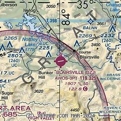
|
| Airport distance calculator |
|---|
|
|
| Sunrise and sunset |
|---|
|
Times for 08-Jun-2026
| | Local
(UTC-4) | | Zulu
(UTC) |
|---|
| Morning civil twilight | | 05:54 | | 09:54 |
| Sunrise | | 06:23 | | 10:23 |
| Sunset | | 20:47 | | 00:47 |
| Evening civil twilight | | 21:16 | | 01:16 |
|
| Current date and time |
|---|
| Zulu (UTC) | 08-Jun-2026 19:48:57 |
|---|
| Local (UTC-4) | 08-Jun-2026 15:48:57 |
|---|
|
| METAR |
|---|
| KDZJ | 081935Z AUTO 26003KT 10SM -RA SCT027 BKN070 OVC100 25/21 A3018 RMK AO2 LTG DSNT N T02490210
|
|
| NOTAMs |
|---|
NOTAMs are issued by the DoD/FAA and will open in a separate window not controlled by AirNav.
|
|


