FAA INFORMATION EFFECTIVE 14 MAY 2026
Location
| FAA Identifier: | AJR |
| Lat/Long: | 34-29-59.4660N 083-33-23.9930W
34-29.991100N 083-33.399883W
34.4998517,-83.5566647
(estimated) |
| Elevation: | 1447.9 ft. / 441.3 m (surveyed) |
| Variation: | 06W (2025) |
| From city: | 2 miles SW of CORNELIA, GA |
| Time zone: | UTC -4 (UTC -5 during Standard Time) |
| Zip code: | 30531 |
Airport Operations
| Airport use: | Open to the public |
| Activation date: | 12/1989 |
| Control tower: | no |
| ARTCC: | ATLANTA CENTER |
| FSS: | MACON FLIGHT SERVICE STATION |
| NOTAMs facility: | MCN (NOTAM-D service available) |
| Attendance: | 0800-1800 |
| Wind indicator: | lighted |
| Segmented circle: | yes |
| Lights: | MIRL RWY 06/24 PRESET ON LOW INTST DUSK-2200; TO INCR INTST - CTAF. AFT 2200 ACTVT - CTAF. |
| Beacon: | white-green (lighted land airport)
Operates sunset to sunrise. |
Airport Communications
| CTAF/UNICOM: | 122.7 |
| WX AWOS-3: | 119.175 (706-778-3675) |
| WX AWOS-3 at TOC (14 nm NE): | 119.625 (706-297-7473) |
| WX ASOS at GVL (19 nm SW): | 126.475 (770-532-4687) |
| WX AWOS-3PT at JCA (19 nm S): | 118.125 (706-387-6477) |
- APCH/DEP SVC PRVDD BY ATLANTA ARTCC ON FREQS 134.8/379.95 (MOUNT OGLETHORPE RCAG).
Nearby radio navigation aids
| VOR radial/distance | | VOR name | | Freq | | Var |
|---|
| ODFr227/17.4 | | FOOTHILLS VOR/DME | | 113.40 | | 00E |
| AHNr341/35.1 | | ATHENS VOR/DME | | 116.95 | | 00E |
| ELWr277/38.5 | | ELECTRIC CITY VORTAC | | 108.60 | | 00E |
| NDB name | | Hdg/Dist | | Freq | | Var | | ID |
|---|
| BARROW COUNTY | | 008/33.9 | | 404 | | 05W | | BMW | -... -- .-- |
Airport Services
| Fuel available: | 100LL JET-A+ |
| Parking: | tiedowns |
| Airframe service: | MAJOR |
| Powerplant service: | MAJOR |
| Bottled oxygen: | NONE |
| Bulk oxygen: | NONE |
Runway Information
Runway 6/24
| Dimensions: | 5503 x 100 ft. / 1677 x 30 m |
| Surface: | asphalt, in good condition |
| Weight bearing capacity: | |
| Runway edge lights: | medium intensity |
| RUNWAY 6 | | RUNWAY 24 |
| Latitude: | 34-29.743900N | | 34-30.238280N |
| Longitude: | 083-33.859215W | | 083-32.940493W |
| Elevation: | 1403.1 ft. | | 1447.4 ft. |
| Traffic pattern: | left | | left |
| Runway heading: | 063 magnetic, 057 true | | 243 magnetic, 237 true |
| Displaced threshold: | 1392 ft. | | no |
| Declared distances: | TORA:5503 TODA:5503 ASDA:5503 LDA:4111 | | TORA:5503 TODA:5503 ASDA:5503 LDA:5503 |
| Markings: | nonprecision, in good condition | | nonprecision, in good condition |
| Visual slope indicator: | 4-light PAPI on left (3.00 degrees glide path) | | 4-light PAPI on left (3.00 degrees glide path) |
| Touchdown point: | yes, no lights | | yes, no lights |
| Obstructions: | 58 ft. trees, 664 ft. from runway, 307 ft. left of centerline, 8:1 slope to clear
APCH RATIO 26:1 TO DSPLCD THR. | | 23 ft. trees, 453 ft. from runway, 163 ft. left of centerline, 11:1 slope to clear |
Airport Ownership and Management from official FAA records
| Ownership: | Publicly-owned |
| Owner: | HABERSHAM COUNTY
555 MONROE STREET, UNIT 20
CLARKESVILLE, GA 30523
Phone (706) 839-0200 |
| Manager: | BILL HARDEN
1112 AIRPORT ROAD
CORNELIA, GA 30531
Phone 706-839-0247
ARPT PHONE NUMBER - (706) 778-0198. |
Additional Remarks
| - | DEER & WILDLIFE ON OR INVOF ARPT. |
| - | FOR CD CTC ATLANTA ARTCC AT 770-210-7692. |
| - | TWY A BTN TWY D AND TWY C CLSD TO ACFT WINGSPAN MORE THAN 80 FT. |
Instrument Procedures
NOTE: All procedures below are presented as PDF files. If you need a reader for these files, you should download the free Adobe Reader.NOT FOR NAVIGATION. Please procure official charts for flight.
FAA instrument procedures published for use from 14 May 2026 at 0901Z to 11 June 2026 at 0900Z.
IAPs - Instrument Approach Procedures |
|---|
| RNAV (GPS) RWY 06 | |
download (281KB) |
| RNAV (GPS) RWY 24 | |
download (211KB) |
| NOTE: Special Alternate Minimums apply | |
download (154KB) |
| NOTE: Special Take-Off Minimums/Departure Procedures apply | |
download (488KB) |
Other nearby airports with instrument procedures:
KTOC - Toccoa Airport-RG Letourneau Field (14 nm NE)
KGVL - Lee Gilmer Memorial Airport (19 nm SW)
KJCA - Jackson County Airport (19 nm S)
18A - Franklin-Hart Airport (23 nm SE)
KDZJ - Blairsville Airport (30 nm NW)
|
|

Road maps at:
MapQuest
Bing
Google
| Aerial photo |
|---|
WARNING: Photo may not be current or correct
 Photo taken 12-Jul-2007
Do you have a better or more recent aerial photo of Habersham County Airport that you would like to share? If so, please send us your photo.
|
| Sectional chart |
|---|
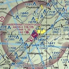
|
| Airport distance calculator |
|---|
|
|
| Sunrise and sunset |
|---|
|
Times for 30-May-2026
| | Local
(UTC-4) | | Zulu
(UTC) |
|---|
| Morning civil twilight | | 05:56 | | 09:56 |
| Sunrise | | 06:24 | | 10:24 |
| Sunset | | 20:39 | | 00:39 |
| Evening civil twilight | | 21:08 | | 01:08 |
|
| Current date and time |
|---|
| Zulu (UTC) | 30-May-2026 10:53:01 |
|---|
| Local (UTC-4) | 30-May-2026 06:53:01 |
|---|
|
| METAR |
|---|
| KAJR | 301035Z AUTO 30003KT 10SM OVC100 19/19 A2995 RMK AO2 T01940190
|
KTOC
14nm NE | 301035Z AUTO 21005KT 10SM OVC090 20/20 A2995 RMK AO2
|
KJCA
19nm S | 301035Z AUTO 25005KT 3SM -RA BR SCT080 BKN110 20/ A2996 RMK AO2 T0202////
|
KGVL
20nm SW | 300953Z AUTO 30004KT 6SM BR OVC100 21/19 A2996 RMK AO2 RAB0857E45 SLP130 P0001 T02060194
|
|
| TAF |
|---|
KAHN
35nm S | 301020Z 3010/3106 00000KT P6SM VCSH SCT002 BKN060 TEMPO 3010/3013 4SM BR BKN002 FM301500 00000KT P6SM -SHRA BKN020 FM301800 32004KT P6SM -SHRA BKN040 PROB30 3018/3022 4SM -TSRA OVC025CB
|
KAND
42nm E | 300534Z 3006/3106 22006KT 6SM BR VCSH FEW009 BKN090 OVC200 TEMPO 3008/3010 4SM BR SCT004 BKN008 FM301100 VRB03KT P6SM VCSH SCT008 OVC040 FM301600 24004KT P6SM VCSH BKN060 PROB30 3017/3023 4SM TSRA BR OVC025CB FM302300 06005KT P6SM VCSH BKN070 FM310100 00000KT P6SM SCT200
|
|
| NOTAMs |
|---|
NOTAMs are issued by the DoD/FAA and will open in a separate window not controlled by AirNav.
|
|


