FAA INFORMATION EFFECTIVE 14 MAY 2026
Location
| FAA Identifier: | RHP |
| Lat/Long: | 35-11-42.8270N 083-51-46.9390W
35-11.713783N 083-51.782317W
35.1952297,-83.8630386
(estimated) |
| Elevation: | 1698.7 ft. / 517.8 m (surveyed) |
| Variation: | 04W (2000) |
| From city: | 2 miles W of ANDREWS, NC |
| Time zone: | UTC -4 (UTC -5 during Standard Time) |
| Zip code: | 28901 |
Airport Operations
| Airport use: | Open to the public |
| Activation date: | 07/1947 |
| Control tower: | no |
| ARTCC: | ATLANTA CENTER |
| FSS: | RALEIGH FLIGHT SERVICE STATION |
| NOTAMs facility: | RHP (NOTAM-D service available) |
| Attendance: | MON-SAT 0900-1700, ALL SUN 1200-1700
UNATNDD THANKSGIVING, CHRISTMAS AND NEW YEARS DAY. |
| Wind indicator: | lighted |
| Segmented circle: | yes |
| Lights: | MIRL RWY 08/26 OPR SS-SR; TO INCR INTST - CTAF. ACTVT REIL RWY 08 - CTAF. PAPI RWY 08 & 26 OPER CONSLY, OTR TIMES - CTAF. |
| Beacon: | white-green (lighted land airport)
LCTD 0.5 MI NORTH OF WEST END OF RWY 08/26. Operates sunset to sunrise. |
Airport Communications
| CTAF/UNICOM: | 122.8 |
| WX AWOS-3P: | 119.675 (828-321-1049) |
- APCH/DEP SVC PRVDD BY ATLANTA ARTCC (ZTL) ON FREQS 134.8/379.95 (MOUNT OGLETHORPE RCAG).
Airport Services
| Fuel available: | 100LL JET-A JET-A1+
100LL:FUEL AVBL 24 HR WITH CREDIT CARD. |
| Parking: | hangars and tiedowns |
| Airframe service: | MAJOR |
| Powerplant service: | MAJOR |
| Bottled oxygen: | NONE |
| Bulk oxygen: | NONE |
Runway Information
Runway 8/26
| Dimensions: | 5500 x 100 ft. / 1676 x 30 m |
| Surface: | asphalt, in excellent condition |
| Weight bearing capacity: | | Single wheel: | 25.0 | | Double wheel: | 45.0 |
|
| Runway edge lights: | medium intensity |
| RUNWAY 8 | | RUNWAY 26 |
| Latitude: | 35-11.568370N | | 35-11.859175N |
| Longitude: | 083-52.305580W | | 083-51.259050W |
| Elevation: | 1682.0 ft. | | 1698.1 ft. |
| Traffic pattern: | right | | left |
| Runway heading: | 075 magnetic, 071 true | | 255 magnetic, 251 true |
| Displaced threshold: | 215 ft. | | no |
| Markings: | nonprecision, in good condition | | nonprecision, in good condition |
| Visual slope indicator: | 2-light PAPI on left (3.50 degrees glide path)
PAPI UNUSBL BYD 6 DEG LEFT AND 8 DEG RIGHT OF CNTRLN DUE TO TRRN. | | 2-light PAPI on left (4.00 degrees glide path)
PAPI UNUSBL BYD 6 DEG RIGHT OF CNTRLN DUE TO TRRN; UNUSBL BYD 2.5 NM FM THR DUE TO TRRN. |
| Runway end identifier lights: | yes | | |
| Touchdown point: | yes, no lights | | yes, no lights |
| Obstructions: | 20 ft. rr, 216 ft. from runway, 246 ft. right of centerline
HAS 5 FT CROPS 0-200 FT FM END OFFSET 150 FT RIGHT OF CNTRLN AND 2 FT BRUSH 189 FT FM END OFFSET 65 FT LEFT OF CNTRLN. | | 51 ft. trees, 1144 ft. from runway, 92 ft. left of centerline, 18:1 slope to clear
3 FT BERM 20 FT FM THLD OFFSET 81 FT RIGHT OF CNTRLN. |
Airport Ownership and Management from official FAA records
| Ownership: | Publicly-owned |
| Owner: | CHEROKEE COUNTY
75 PEACHTREE STREET
MURPHY, NC 28906
Phone 828-835-8578 |
| Manager: | CHRIS WILLIAMS
5840 AIRPORT ROAD
ANDREWS, NC 28901
Phone 828-321-5114 |
Additional Remarks
| - | LOW FLYING MIL JET ACFT OVERFLY ARPT. |
| - | TWY UNLGTD. |
| - | 4-5 FT DITCH 75 FT FROM RWY CNTRLN ON BOTH SIDES. |
| - | RWY 08 RR 390 FT RIGHT OF CNTRLN 260 FT FM THLD. |
| - | ARPT SRNDD BY HIGH TRRN. |
| - | RWY 08, 8 FT DROP-OFF, 108 FT FM THLD BOTH SIDES IN RWY SAFETY AREA. |
| - | COLD TEMPERATURE AIRPORT. ALTITUDE CORRECTION REQUIRED AT OR BELOW -4C. |
| - | FOR CD CTC ATLANTA ARTCC AT 770-210-7692. |
| - | LIVESTOCK PASTURED INVOF ARPT. |
Instrument Procedures
NOTE: All procedures below are presented as PDF files. If you need a reader for these files, you should download the free Adobe Reader.NOT FOR NAVIGATION. Please procure official charts for flight.
FAA instrument procedures published for use from 14 May 2026 at 0901Z to 11 June 2026 at 0900Z.
IAPs - Instrument Approach Procedures |
|---|
| RNAV (GPS) RWY 08 | |
download (341KB) |
| NOTE: Special Take-Off Minimums/Departure Procedures apply | |
download (391KB) |
Other nearby airports with instrument procedures:
KDZJ - Blairsville Airport (21 nm S)
1A5 - Macon County Airport (22 nm E)
1A3 - Martin Campbell Field Airport (26 nm SW)
24A - Jackson County Airport (33 nm E)
KMNV - Monroe County Airport (33 nm NW)
|
|

Road maps at:
MapQuest
Bing
Google
| Aerial photo |
|---|
WARNING: Photo may not be current or correct
 Photo by Eve Cascella
Photo taken 13-Sep-2010
looking north.
Photo by Eve Cascella
Photo taken 13-Sep-2010
looking north.
Do you have a better or more recent aerial photo of Western Carolina Regional Airport that you would like to share? If so, please send us your photo.
|
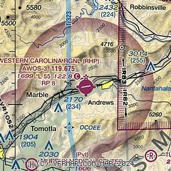
| Sectional chart |
|---|
|
| Airport distance calculator |
|---|
|
|
| Sunrise and sunset |
|---|
|
Times for 05-Jun-2026
| | Local
(UTC-4) | | Zulu
(UTC) |
|---|
| Morning civil twilight | | 05:53 | | 09:53 |
| Sunrise | | 06:22 | | 10:22 |
| Sunset | | 20:46 | | 00:46 |
| Evening civil twilight | | 21:15 | | 01:15 |
|
| Current date and time |
|---|
| Zulu (UTC) | 05-Jun-2026 08:45:14 |
|---|
| Local (UTC-4) | 05-Jun-2026 04:45:14 |
|---|
|
| METAR |
|---|
| KRHP | 050835Z AUTO 00000KT 10SM CLR 11/10 A3023 RMK AO2 T01130102
|
|
| TAF |
|---|
KTYS
38nm N | 050520Z 0506/0606 VRB03KT P6SM SKC FM051600 25009KT P6SM SCT250
|
|
| NOTAMs |
|---|
NOTAMs are issued by the DoD/FAA and will open in a separate window not controlled by AirNav.
|
|

