FAA INFORMATION EFFECTIVE 09 JULY 2026
Location
| FAA Identifier: | ESF |
| Lat/Long: | 31-23-41.6550N 092-17-44.7830W
31-23.694250N 092-17.746383W
31.3949042,-92.2957731
(estimated) |
| Elevation: | 111.8 ft. / 34.1 m (surveyed) |
| Variation: | 01E (2010) |
| From city: | 10 miles NE of ALEXANDRIA, LA |
| Time zone: | UTC -5 (UTC -6 during Standard Time) |
| Zip code: | 71360 |
Airport Operations
| Airport use: | Open to the public |
| Activation date: | 01/1941 |
| Control tower: | no |
| ARTCC: | HOUSTON CENTER |
| FSS: | DE RIDDER FLIGHT SERVICE STATION |
| NOTAMs facility: | ESF (NOTAM-D service available) |
| Attendance: | TUE-FRI 0700-1730 |
| Wind indicator: | lighted |
| Segmented circle: | yes |
| Lights: | ACTVT MALSR RWY 27; REIL RWY 09, 14/32; MIRL RWY 14/32; HIRL RWY 9/27; TWY LGTS TWYS A, B, C, D & E - CTAF. |
| Beacon: | white-green (lighted land airport)
Operates sunset to sunrise. |
Airport Communications
| CTAF/UNICOM: | 122.8 |
| WX ASOS: | 119.425 (318-484-9031) |
| MAKS APPROACH: | 125.4 |
| MAKS DEPARTURE: | 125.4 |
| WX ASOS at AEX (14 nm W): | 123.975 (318-442-6583) |
Nearby radio navigation aids
| VOR radial/distance | | VOR name | | Freq | | Var |
|---|
| AEXr049/13.4 | | ALEXANDRIA VORTAC | | 116.10 | | 03E |
Airport Services
| Fuel available: | 100LL JET-A
100LL:FUEL AVBL TUE-FRI 0700-1700; SAT-MON ON CALL IN ADVANCE CALL 318-443-5566. 100LL SELF SERVE 24HRS |
| Parking: | tiedowns |
Runway Information
Runway 9/27
| Dimensions: | 5998 x 150 ft. / 1828 x 46 m |
| Surface: | asphalt/grooved, in good condition |
| Weight bearing capacity: | | Single wheel: | 75.0 | | Double wheel: | 150.0 | | Double tandem: | 220.0 |
|
| Runway edge lights: | high intensity |
| RUNWAY 9 | | RUNWAY 27 |
| Latitude: | 31-23.666300N | | 31-23.651325N |
| Longitude: | 092-18.360000W | | 092-17.206783W |
| Elevation: | 96.2 ft. | | 89.4 ft. |
| Traffic pattern: | left | | left |
| Runway heading: | 090 magnetic, 091 true | | 270 magnetic, 271 true |
| Markings: | precision, in good condition | | precision, in good condition |
| Visual slope indicator: | 4-light PAPI on left (3.00 degrees glide path) | | |
| Approach lights: | | | MALSR: 1,400 foot medium intensity approach lighting system with runway alignment indicator lights |
| Runway end identifier lights: | yes
RWY 09 REILS OTS | | |
| Touchdown point: | yes, no lights | | yes, no lights |
| Instrument approach: | | | ILS/DME |
| Obstructions: | 82 ft. trees, 3080 ft. from runway, 35:1 slope to clear | | none |
Runway 14/32
| Dimensions: | 5600 x 150 ft. / 1707 x 46 m |
| Surface: | asphalt/grooved, in fair condition |
| Weight bearing capacity: | | Single wheel: | 75.0 | | Double wheel: | 150.0 | | Double tandem: | 220.0 |
|
| Runway edge lights: | medium intensity |
| Runway edge markings: | RWY MARKINGS SEVERELY FADED |
| RUNWAY 14 | | RUNWAY 32 |
| Latitude: | 31-24.110117N | | 31-23.354217N |
| Longitude: | 092-18.016217W | | 092-17.397295W |
| Elevation: | 111.6 ft. | | 87.7 ft. |
| Traffic pattern: | left | | left |
| Runway heading: | 144 magnetic, 145 true | | 324 magnetic, 325 true |
| Markings: | precision, in poor condition | | precision, in poor condition |
| Visual slope indicator: | 4-light PAPI on left (3.00 degrees glide path)
RWY 14 PAPI OTS | | 4-light PAPI on left (3.00 degrees glide path) |
| Runway end identifier lights: | yes
RWY 14 REIL OTS | | yes |
| Touchdown point: | yes, no lights | | yes, no lights |
| Obstructions: | 116 ft. trees, 2056 ft. from runway, 1324 ft. both sides of centerline, 16:1 slope to clear | | 5 ft. fence, 185 ft. from runway
FENCE 100 FT 0B AND SMALL TREE 14 FT TALL 232 FT FM END OF RY. |
Airport Ownership and Management from official FAA records
| Ownership: | Publicly-owned |
| Owner: | RAPIDES PARISH POLICE JURY
PO BOX 1150
ALEXANDRIA, LA 71309
Phone 318-767-2536 |
| Manager: | LOUIS BUSBY
7625 ESLER FIELD RD
PINEVILLE, LA 71360
Phone 985-750-0485 |
Additional Remarks
| - | BIRDS ON & INVOF ARPT SEASONALLY. |
| - | PAEW ADJ RWYS & TWYS. |
| - | FOR CD CTC MAKS APCH AT 726-780-0456. |
| - | CTC APRT MGR FOR DSGND RAMP SPACE FOR PUB USE. |
| A25 | PL 85-204/SPECIAL ACT OF CONGRESS |
Instrument Procedures
NOTE: All procedures below are presented as PDF files. If you need a reader for these files, you should download the free Adobe Reader.NOT FOR NAVIGATION. Please procure official charts for flight.
FAA instrument procedures published for use from 09 July 2026 at 0901Z to 06 August 2026 at 0900Z.
IAPs - Instrument Approach Procedures |
|---|
| ILS OR LOC/DME RWY 27 | |
download (252KB) |
| RNAV (GPS) RWY 09 | |
download (257KB) |
| RNAV (GPS) RWY 27 | |
download (280KB) |
| NOTE: Special Alternate Minimums apply | |
download (20KB) |
| NOTE: Special Take-Off Minimums/Departure Procedures apply | |
download (116KB) |
Other nearby airports with instrument procedures:
KAEX - Alexandria International Airport (14 nm W)
KMKV - Marksville Municipal Airport (21 nm SE)
2R6 - Bunkie Municipal Airport (26 nm S)
0R5 - David G Joyce Airport (39 nm NW)
0R4 - Concordia Parish Airport (42 nm E)
|
|

Road maps at:
MapQuest
Bing
Google
| Aerial photo |
|---|
WARNING: Photo may not be current or correct
 Photo by Jordan and Kirsten Eastridge
Photo taken 21-Apr-2010
from the northwest.
Photo by Jordan and Kirsten Eastridge
Photo taken 21-Apr-2010
from the northwest.
Do you have a better or more recent aerial photo of Esler Regional Airport that you would like to share? If so, please send us your photo.
|
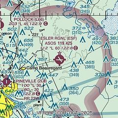
| Sectional chart |
|---|
|
| Airport distance calculator |
|---|
|
|
| Sunrise and sunset |
|---|
|
Times for 27-Jul-2026
| | Local
(UTC-5) | | Zulu
(UTC) |
|---|
| Morning civil twilight | | 05:57 | | 10:57 |
| Sunrise | | 06:23 | | 11:23 |
| Sunset | | 20:08 | | 01:08 |
| Evening civil twilight | | 20:35 | | 01:35 |
|
| Current date and time |
|---|
| Zulu (UTC) | 27-Jul-2026 11:38:40 |
|---|
| Local (UTC-5) | 27-Jul-2026 06:38:40 |
|---|
|
| METAR |
|---|
| KESF | 271053Z AUTO 00000KT 5SM BR CLR 24/23 A2997 RMK AO2 SLP145 T02390233
|
KAEX
14nm W | 271053Z 00000KT 8SM BKN070 25/24 A2998 RMK AO2 SLP152 T02500239
|
|
| TAF |
|---|
KAEX
14nm W | 270520Z 2706/2806 22004KT P6SM SKC TEMPO 2710/2712 4SM BR FM271500 24006KT P6SM SCT250 FM280000 18004KT P6SM SKC
|
|
| NOTAMs |
|---|
NOTAMs are issued by the DoD/FAA and will open in a separate window not controlled by AirNav.
|
|


