FAA INFORMATION EFFECTIVE 09 JULY 2026
Location
| FAA Identifier: | FCT |
| Lat/Long: | 46-40-09.9090N 120-27-21.4790W
46-40.165150N 120-27.357983W
46.6694192,-120.4559664
(estimated) |
| Elevation: | 1378.1 ft. / 420.0 m (surveyed) |
| Variation: | 20E (1985) |
| From city: | 5 miles NE of YAKIMA, WA |
| Time zone: | UTC -7 (UTC -8 during Standard Time) |
| Zip code: | 98901 |
Heliport Operations
| Heliport use: | Private use. Permission required prior to landing |
| Control tower: | no |
| ARTCC: | SEATTLE CENTER |
| FSS: | SEATTLE FLIGHT SERVICE STATION |
| NOTAMs facility: | SEA (NOTAM-D service available) |
| Attendance: | MON-FRI 1600-0800Z++ |
| Wind indicator: | yes |
| Segmented circle: | no |
| Lights: | ACTVT MIRL RY 05/23 - CTAF. |
| Beacon: | white-green (lighted land airport)
Operates sunset to sunrise. |
Heliport Communications
| CTAF: | 126.2 |
| WX ASOS: | 118.15 |
| WX ASOS at YKM (7 nm SW): | PHONE 509-426-3051 |
- 72 HRS PPR FOR ATC AFTER NORMAL DUTY HOURS.
- RATTLESNAKE- RDO-OPR 0800Z++MON----0800Z++ AND 1700-0100Z++SAT-SUN, CLSD HOL.
- RANGE CTL 40.2 OPS 142.3 395.225 REMOTED TO GRAY AAF, AW (KGRF), MANNED 0800Z++MON-0800Z++FRI AND 1700-0100Z++SAT-SUN, CLSD HOL.
Nearby radio navigation aids
| VOR radial/distance | | VOR name | | Freq | | Var |
|---|
| YKMr335/6.0 | | YAKIMA VORTAC | | 116.00 | | 21E |
| ELNr159/21.3 | | ELLENSBURG VOR/DME | | 117.90 | | 21E |
Heliport Services
| Fuel available: | POL 0800-1530 ++ OTHER TIMES 8 HR PRIOR NOTICE SAT SUN V355-8311 C509-577-3204. |
Runway Information
Runway 5/23
| Dimensions: | 1602 x 50 ft. / 488 x 15 m |
| Surface: | asphalt |
| Runway edge lights: | medium intensity |
| RUNWAY 5 | | RUNWAY 23 |
| Latitude: | 46-40.117817N | | 46-40.212483N |
| Longitude: | 120-27.536650W | | 120-27.179300W |
| Elevation: | 1375.3 ft. | | 1375.5 ft. |
| Traffic pattern: | right | | left |
| Runway heading: | 049 magnetic, 069 true | | 229 magnetic, 249 true |
| Touchdown point: | yes, no lights | | yes, no lights |
Heliport Ownership and Management from official FAA records
| Ownership: | U.S. Army |
| Owner: | US ARMY AERONAUTICAL SVCS AGENCY
FT BELVOIR, VA 22060 |
| Manager: | KENNETH GORDON
Phone 509-577-3719 |
Additional Remarks
| - | PPR SINGLE ENGINE F/W ACFT, MULTI-ENGINE ACFT NA. |
| - | OPS - 142.3 395.225 REMOTED TO GRAY AAF, WA (KGRF) MANNED CONT. CLSD HOL. |
| - | BE AWARE OF POWERLINES EAST OF RY. |
| - | WX SVCS CONTACT KGRF WX C253-967-7061 OR 25 OWS, DAVIS-MONTHAN AFB, DSN228-6598. |
| - | ACFT PARKING LIMITED AND CAN'T BE ASSURED. RON CAN'T BE ASSURED. ALL ACFT CTC RATTLESNAKE RADIO PRIOR TO ENTRY R6714 A-D, F-H. |
| - | RSTD - 24 HR PPR CTC BASE OPS DSN 638-3271, C509-577-3271. |
| - | SERVICE - FUEL F24 (MIL); 1600-0800Z++, DSN 638-3367, C509-577-3367, OT C509-317-1017 |
| - | FOR CD CTC SEATTLE ARTCC AT 253-351-3694. |
Instrument Procedures
There are no published instrument procedures at KFCT.
Some nearby airports with instrument procedures:
KYKM - Yakima Air Terminal/McAllister Field (7 nm SW)
KELN - Bowers Field Airport (22 nm N)
KEAT - Pangborn Memorial Airport (45 nm N)
KRLD - Richland Airport (52 nm SE)
KEPH - Ephrata Municipal Airport (54 nm NE)
|
|

Road maps at:
MapQuest
Bing
Google
| Aerial photo |
|---|

|
| Sectional chart |
|---|
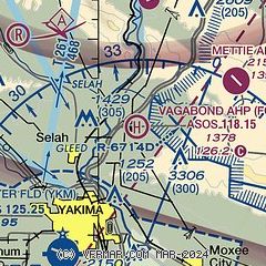
|
| Airport distance calculator |
|---|
|
|
| Sunrise and sunset |
|---|
|
Times for 27-Jul-2026
| | Local
(UTC-7) | | Zulu
(UTC) |
|---|
| Morning civil twilight | | 05:01 | | 12:01 |
| Sunrise | | 05:37 | | 12:37 |
| Sunset | | 20:39 | | 03:39 |
| Evening civil twilight | | 21:15 | | 04:15 |
|
| Current date and time |
|---|
| Zulu (UTC) | 27-Jul-2026 11:59:49 |
|---|
| Local (UTC-7) | 27-Jul-2026 04:59:49 |
|---|
|
| METAR |
|---|
KYKM
7nm SW | 271053Z AUTO 00000KT 10SM CLR 13/09 A3000 RMK AO2 SLP152 T01330089 $
|
|
| TAF |
|---|
KYKM
7nm SW | 270525Z 2706/2806 27004KT P6SM SKC FM271900 17006KT P6SM SKC FM280100 28009KT P6SM SKC
|
|
| NOTAMs |
|---|
NOTAMs are issued by the DoD/FAA and will open in a separate window not controlled by AirNav.
|
|

