FAA INFORMATION EFFECTIVE 16 APRIL 2026
Location
| FAA Identifier: | FOD |
| Lat/Long: | 42-33-04.3000N 094-11-30.6000W
42-33.071667N 094-11.510000W
42.5511944,-94.1918333
(estimated) |
| Elevation: | 1156.3 ft. / 352.4 m (surveyed) |
| Variation: | 02E (2010) |
| From city: | 3 miles N of FORT DODGE, IA |
| Time zone: | UTC -5 (UTC -6 during Standard Time) |
| Zip code: | 50501 |
Airport Operations
| Airport use: | Open to the public |
| Activation date: | 10/1952 |
| Control tower: | no |
| ARTCC: | MINNEAPOLIS CENTER |
| FSS: | FORT DODGE FLIGHT SERVICE STATION |
| NOTAMs facility: | FOD (NOTAM-D service available) |
| Attendance: | 0500-1600
FOR ATTENDANT AFT HRS CALL (515) 955-3434/570-6206 |
| Pattern altitude: | 1999.3 ft. MSL |
| Wind indicator: | lighted |
| Segmented circle: | no |
| Lights: | ACTVT HIRL RY 06/24; MIRL RY 12/30; REIL RYS 12, 24 & 30; MALSR RY 06 & VASI RYS 12 & 24 & PAPI RYS 06 & 30 - CTAF. |
| Beacon: | white-green (lighted land airport)
Operates sunset to sunrise. |
| Fire and rescue: | ARFF index A |
| Airline operations: | ARFF INDEX B AVBL PPR CTC ARPT OPS 712-541-5790. |
Airport Communications
| CTAF/UNICOM: | 123.0 |
| WX AWOS-3PT: | 118.775 (515-955-5490) |
| WX AWOS-3 at EBS (16 nm SE): | 127.825 (515-832-2794) |
- APCH/DEP SVC PRVDD BY MINNEAPOLIS ARTCC ON FREQS 134.0/288.3 (FORT DODGE RCAG).
Nearby radio navigation aids
| NDB name | | Hdg/Dist | | Freq | | Var | | ID |
|---|
| BARRO | | 064/5.5 | | 341 | | 02E | | FO | ..-. --- |
Airport Services
| Fuel available: | 100LL JET-A
100LL:100LL AND JET A SELF-SVC FUEL AVBL. |
| Parking: | hangars and tiedowns |
| Airframe service: | MAJOR |
| Powerplant service: | MAJOR |
| Bottled oxygen: | NONE |
| Bulk oxygen: | NONE |
Runway Information
Runway 6/24
| Dimensions: | 6547 x 150 ft. / 1996 x 46 m |
| Surface: | asphalt/grooved, in excellent condition |
| Weight bearing capacity: | | Single wheel: | 65.0 | | Double wheel: | 110.0 | | Double tandem: | 165.0 |
|
| Runway edge lights: | high intensity |
| RUNWAY 6 | | RUNWAY 24 |
| Latitude: | 42-32.857600N | | 42-33.313050N |
| Longitude: | 094-12.344645W | | 094-11.023472W |
| Elevation: | 1079.5 ft. | | 1156.3 ft. |
| Traffic pattern: | left | | left |
| Runway heading: | 063 magnetic, 065 true | | 243 magnetic, 245 true |
| Declared distances: | TORA:6547 TODA:6547 ASDA:6547 LDA:6547 | | TORA:6547 TODA:6547 ASDA:6547 LDA:6547 |
| Markings: | precision, in good condition | | nonprecision, in good condition |
| Visual slope indicator: | 4-light PAPI on left (3.00 degrees glide path) | | 4-box VASI on left (3.00 degrees glide path) |
| Approach lights: | MALSR: 1,400 foot medium intensity approach lighting system with runway alignment indicator lights | | |
| Runway end identifier lights: | | | yes |
| Touchdown point: | yes, no lights | | yes, no lights |
| Instrument approach: | ILS | | |
Runway 12/30
| Dimensions: | 5301 x 100 ft. / 1616 x 30 m |
| Surface: | asphalt/grooved, in excellent condition |
| Weight bearing capacity: | | Single wheel: | 36.0 | | Double wheel: | 58.0 |
|
| Runway edge lights: | medium intensity |
| RUNWAY 12 | | RUNWAY 30 |
| Latitude: | 42-33.317918N | | 42-32.793048N |
| Longitude: | 094-11.767585W | | 094-10.824760W |
| Elevation: | 1112.3 ft. | | 1141.8 ft. |
| Traffic pattern: | left | | left |
| Runway heading: | 125 magnetic, 127 true | | 305 magnetic, 307 true |
| Declared distances: | TORA:5301 TODA:5301 ASDA:5301 LDA:5301 | | TORA:5301 TODA:5301 ASDA:5301 LDA:5301 |
| Markings: | nonprecision, in good condition | | nonprecision, in good condition |
| Visual slope indicator: | 4-box VASI on left (3.00 degrees glide path) | | 4-light PAPI on left (3.00 degrees glide path) |
| Runway end identifier lights: | yes | | yes |
| Touchdown point: | yes, no lights | | yes, no lights |
| Obstructions: | none | | 30 ft. pole, 1340 ft. from runway, 224 ft. left of centerline, 38:1 slope to clear |
Airport Ownership and Management from official FAA records
| Ownership: | Publicly-owned |
| Owner: | CITY OF FORT DODGE
819 FIRST AVE SOUTH
FORT DODGE, IA 50501
Phone 515-573-7144 |
| Manager: | MRS. SARAH RUSTVOLD
1639 NELSON AVE SUITE 2
FORT DODGE, IA 50501
Phone 515-573-3881
EMAIL ADDRESS: SRUSTVOLD@FORTDODGEIOWA.ORG (ALL LOWER CASE) |
Additional Remarks
| A39-12/30 | PCR VALUE: 180/R/C/W/T |
| A39-06/24 | PCR VALUE: 610/F/C/X/T |
| - | ACR OPNS INVOLVING ACFT WITH MORE THAN 9 PASSENGER SEATS ARE NOT AUTHORIZED IN EXCESS OF 15 MINS BEFORE OR AFT SCHEDULED ARR OR DEP TIMES WITHOUT PRIOR COORD WITH ARPT MANAGEMENT AND/OR ARPT MAINT & CONFIRMATION THAT ARFF SVCS ARE AVBL PRIOR TO LANDING OR TAKEOFF. |
| - | RY 06 IS CALM WIND RY. |
| - | SFC CONDS NOT MONTRD ON WKENDS AND BTWN 1600-0500 MON-FRI. |
| - | FOR CD IF UNA TO CTC ON FSS FREQ, CTC MINNEAPOLIS ARTCC AT 651-463-5588. |
Instrument Procedures
NOTE: All procedures below are presented as PDF files. If you need a reader for these files, you should download the free Adobe Reader.NOT FOR NAVIGATION. Please procure official charts for flight.
FAA instrument procedures published for use from 16 April 2026 at 0901Z to 14 May 2026 at 0900Z.
IAPs - Instrument Approach Procedures |
|---|
| ILS OR LOC RWY 06 | |
download (247KB) |
| RNAV (GPS) RWY 06 | |
download (264KB) |
| RNAV (GPS) RWY 12 | |
download (245KB) |
| RNAV (GPS) RWY 24 | |
download (255KB) |
| RNAV (GPS) RWY 30 | |
download (247KB) |
| NOTE: Special Alternate Minimums apply | |
download (146KB) |
| NOTE: Special Take-Off Minimums/Departure Procedures apply | |
download (158KB) |
Other nearby airports with instrument procedures:
KEAG - Eagle Grove Municipal Airport (15 nm NE)
KEBS - Webster City Municipal Airport (16 nm SE)
KCAV - Clarion Municipal Airport (22 nm NE)
KPOH - Pocahontas Municipal Airport (23 nm NW)
KAXA - Algona Municipal Airport (32 nm N)
|
|

Road maps at:
MapQuest
Bing
Google
| Aerial photo |
|---|
WARNING: Photo may not be current or correct
 Photo by Melissa Van Osdel
Photo taken 16-Oct-2008
Photo by Melissa Van Osdel
Photo taken 16-Oct-2008
Do you have a better or more recent aerial photo of Fort Dodge Regional Airport that you would like to share? If so, please send us your photo.
|
| Sectional chart |
|---|
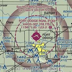
|
 Download PDF
of official airport diagram from the FAA
| Airport distance calculator |
|---|
|
|
| Sunrise and sunset |
|---|
|
Times for 07-May-2026
| | Local
(UTC-5) | | Zulu
(UTC) |
|---|
| Morning civil twilight | | 05:33 | | 10:33 |
| Sunrise | | 06:05 | | 11:05 |
| Sunset | | 20:22 | | 01:22 |
| Evening civil twilight | | 20:53 | | 01:53 |
|
| Current date and time |
|---|
| Zulu (UTC) | 07-May-2026 22:40:46 |
|---|
| Local (UTC-5) | 07-May-2026 17:40:46 |
|---|
|
| METAR |
|---|
KFOD
2nm SE | 072156Z AUTO 24004KT 10SM CLR 19/M04 A2981 RMK AO2 SLP107 T01891044 $
|
KEBS
16nm SE | 072215Z AUTO 29006G14KT 10SM CLR 19/M06 A2978 RMK AO2
|
|
| TAF |
|---|
KFOD
2nm SE | 071720Z 0718/0818 VRB05KT P6SM SKC
|
|
| NOTAMs |
|---|
NOTAMs are issued by the DoD/FAA and will open in a separate window not controlled by AirNav.
|
|


