FAA INFORMATION EFFECTIVE 14 MAY 2026
Location
| FAA Identifier: | FSD |
| Lat/Long: | 43-34-55.2650N 096-44-30.9310W
43-34.921083N 096-44.515517W
43.5820181,-96.7419253
(estimated) |
| Elevation: | 1430 ft. / 435.9 m (surveyed) |
| Variation: | 05E (2000) |
| From city: | 3 miles NW of SIOUX FALLS, SD |
| Time zone: | UTC -5 (UTC -6 during Standard Time) |
| Zip code: | 57104 |
Airport Operations
| Airport use: | Open to the public |
| Activation date: | 11/1938 |
| Control tower: | yes |
| ARTCC: | MINNEAPOLIS CENTER |
| FSS: | HURON FLIGHT SERVICE STATION |
| NOTAMs facility: | FSD (NOTAM-D service available) |
| Attendance: | CONTINUOUS |
| Wind indicator: | lighted |
| Segmented circle: | yes |
| Lights: | ACTVT MALSR RWY 03 & 21; REIL RWY 15 & 33; HIRL RWY 03/21 & 15/33; MIRL RWY 9/27. WHEN ATCT CLSD MALSR RWY 03 & 21 PRESET ON LOW INTST, TO INCR INTST - CTAF. PAPI RWY 03, 21, 15, 33 OPR CONSLY. |
| Beacon: | white-green (lighted land airport)
Operates sunset to sunrise. |
| Fire and rescue: | ARFF index B |
| International operations: | customs landing rights airport |
Airport Communications
| CTAF: | 118.3 |
| UNICOM: | 122.95 |
| ATIS: | 126.6 |
| WX ASOS: | PHONE 605-204-9608 |
| SIOUX FALLS GROUND: | 121.9 348.6 [0500-0000] |
| SIOUX FALLS TOWER: | 118.3 257.8 [0500-0000] |
| SIOUX FALLS APPROACH: | 125.8 284.725 [0500-0000] |
| MINNEAPOLIS ARTCC APPROACH: | 126.9 353.6 [0000-0500] |
| SIOUX FALLS DEPARTURE: | 125.8 284.725 [0500-0000] |
| MINNEAPOLIS ARTCC DEPARTURE: | 126.9 353.6 [0000-0500] |
| COMD POST: | 138.25 253.4 36.85FM |
| EMERG: | 121.5 243.0 |
| OPS: | 390.1 ;BASE MAINT |
- APCH/DEP SVC PRVDD BY MINNEAPOLIS ARTCC ON FREQ 132.050/317.4 (SIOUX FALLS RCAG) WHEN SIOUX FALLS APCH CTL IS CLSD.
- BASE COMMAND POST CALL (CLARENCE 49).
Nearby radio navigation aids
| VOR radial/distance | | VOR name | | Freq | | Var |
|---|
| FSDr148/4.4 | | SIOUX FALLS VORTAC | | 115.00 | | 09E |
| NDB name | | Hdg/Dist | | Freq | | Var | | ID |
|---|
| ROKKY | | 031/6.5 | | 245 | | 05E | | FS | ..-. ... |
Airport Services
| Fuel available: | 100LL JET-A |
| Parking: | hangars and tiedowns |
| Airframe service: | MAJOR |
| Powerplant service: | MAJOR |
| Bottled oxygen: | HIGH |
| Bulk oxygen: | HIGH |
Runway Information
Runway 3/21
| Dimensions: | 9000 x 150 ft. / 2743 x 46 m |
| Surface: | concrete/grooved, in good condition |
| Weight bearing capacity: | | Single wheel: | 120.0 | | Double wheel: | 250.0 | | Double tandem: | 431.0 | | Dual double tandem: | 940.0 |
|
| Runway edge lights: | high intensity |
| RUNWAY 3 | | RUNWAY 21 |
| Latitude: | 43-34.357023N | | 43-35.571927N |
| Longitude: | 096-45.222250W | | 096-44.056413W |
| Elevation: | 1423.5 ft. | | 1430.0 ft. |
| Traffic pattern: | left | | left |
| Runway heading: | 030 magnetic, 035 true | | 210 magnetic, 215 true |
| Declared distances: | TORA:8999 TODA:8999 ASDA:8999 LDA:8999 | | TORA:8999 TODA:8999 ASDA:8999 LDA:8999 |
| Markings: | precision, in good condition | | precision, in good condition |
| Visual slope indicator: | 4-light PAPI on left (3.00 degrees glide path) | | 4-light PAPI on left (3.00 degrees glide path) |
| RVR equipment: | touchdown | | touchdown |
| Approach lights: | MALSR: 1,400 foot medium intensity approach lighting system with runway alignment indicator lights | | MALSR: 1,400 foot medium intensity approach lighting system with runway alignment indicator lights |
| Runway end identifier lights: | no | | no |
| Centerline lights: | yes | | yes |
| Touchdown point: | yes, no lights | | yes, lighted |
| Instrument approach: | ILS | | ILS |
| Obstructions: | 8 ft. road, 283 ft. from runway, 511 ft. left of centerline, 10:1 slope to clear | | 27 ft. rr, 1178 ft. from runway, 645 ft. right of centerline, 35:1 slope to clear |
Runway 15/33
| Dimensions: | 8000 x 150 ft. / 2438 x 46 m |
| Surface: | concrete/grooved, in good condition |
| Weight bearing capacity: | | Single wheel: | 120.0 | | Double wheel: | 232.0 | | Double tandem: | 352.0 | | Dual double tandem: | 811.0 |
|
| Runway edge lights: | high intensity |
| RUNWAY 15 | | RUNWAY 33 |
| Latitude: | 43-35.587662N | | 43-34.394868N |
| Longitude: | 096-44.763862W | | 096-43.996698W |
| Elevation: | 1429.2 ft. | | 1422.4 ft. |
| Traffic pattern: | left | | left |
| Runway heading: | 150 magnetic, 155 true | | 330 magnetic, 335 true |
| Declared distances: | TORA:8000 TODA:8000 ASDA:8000 LDA:8000 | | TORA:8000 TODA:8000 ASDA:8000 LDA:8000 |
| Markings: | nonprecision, in good condition | | nonprecision, in good condition |
| Visual slope indicator: | 4-light PAPI on left (3.00 degrees glide path)
PAPI UNUSBL BYD 6 DEGS LEFT AND 5 DEGS RIGHT OF CNTRLN. | | 4-light PAPI on left (3.00 degrees glide path)
PAPI UNUSBL BYD 9 DEGS RIGHT OF CNTRLN. |
| Runway end identifier lights: | yes | | yes |
| Touchdown point: | yes, no lights | | yes, no lights |
| Obstructions: | 109 ft. tree, 3786 ft. from runway, 702 ft. right of centerline, 33:1 slope to clear
ALSO LGTD TWR; 4962 FM RY END; 159 ABV RY END; 893 R OF CNTRLN; 29:1 SLOPE. | | 47 ft. tree, 1455 ft. from runway, 327 ft. right of centerline, 26:1 slope to clear |
Runway 9/27
| Dimensions: | 3151 x 75 ft. / 960 x 23 m |
| Surface: | concrete/wired/combed, in fair condition |
| Weight bearing capacity: | | PCN 60 /R/B/W/T | | Single wheel: | 30.0 |
|
| Runway edge lights: | medium intensity |
| Operational restrictions: | RWY 09/27 NOT AVBL FOR PART 121/PART 380 OPS WITH SKED PAX CARRYING OPS MORE THAN 9 PAX SEATS AND NON-SKED PAX CARRYING OPS MORE THAN 30 PAX SEATS. NO PART 121/PART 380 OPS EXC FOR TAX. |
| RUNWAY 9 | | RUNWAY 27 |
| Latitude: | 43-34.678037N | | 43-34.559740N |
| Longitude: | 096-44.852387W | | 096-44.157743W |
| Elevation: | 1422.6 ft. | | 1421.9 ft. |
| Traffic pattern: | left | | left |
| Runway heading: | 098 magnetic, 103 true | | 278 magnetic, 283 true |
| Markings: | basic, in good condition | | basic, in good condition |
| Runway end identifier lights: | no | | no |
| Touchdown point: | yes, no lights | | yes, no lights |
| Obstructions: | 71 ft. tree, 2550 ft. from runway, 376 ft. right of centerline, 33:1 slope to clear | | 149 ft. pole, 4620 ft. from runway, 461 ft. right of centerline, 29:1 slope to clear |
Helipad H1
| Dimensions: | 50 x 50 ft. / 15 x 15 m |
| Surface: | asphalt, in good condition |
| Runway edge lights: | PERI |
| Latitude: | 43-35.169000N | | |
| Longitude: | 096-44.202833W | | |
| Elevation: | 1422.0 ft. | | |
| Traffic pattern: | left | | left |
| Touchdown point: | yes, no lights | | no |
Airport Ownership and Management from official FAA records
| Ownership: | Publicly-owned |
| Owner: | SIOUX FALLS REGNL ARPT AUTH
2801 JAYCEE LANE
SIOUX FALLS, SD 57104
Phone 605-336-0762 |
| Manager: | DANIEL J. LETELLIER
2801 JAYCEE LANE
SIOUX FALLS, SD 57104
Phone 605-336-0762 |
Additional Remarks
| A39-03/21 | PCR VALUE: 960/R/D/W/T |
| A39-15/33 | PCR VALUE: 780/R/D/W/T |
| E60-33 | BAK-14 BAK-12B(B) (1500'). |
| E60-21 | BAK-14 BAK-12B(B) (1500'). |
| E60-03 | BAK-14 BAK-12B(B) (1540'). |
| E60-15 | BAK-14 BAK-12B(B) (1550'). |
| - | MIGRATORY BIRDS WITHIN 25 NM PRIMARILY BETWEEN MAR-NOV. |
| - | EAST GA RAMP RESTRICTED TO 60,000 LBS. |
| - | ATCT HAS LIMITED VIS ON TWYS HOTEL, GOLF AND JULIET BTN THE EAST CARGO RAMP AND TWY BRAVO. |
| - | BE ALERT: MARV SKIE-LINCOLN COUNTY AIRPORT (Y14) LOCATED 7.2 MILES SW OF FSD & 2 MILES EAST OF ROKKY HAS HEAVY VFR TRAFFIC. |
| - | ANG: NUMEROUS NSTD MRK ON THE ANG PRK APRON. COMSEC STORAGE UNAVBL.BASH PHASE II OPS EFF MAR-APR, SEP-OCT; EXP INCR BIRD ACT; CTC ANG BASE OPS. |
| - | MILITARY: SVC: FUEL: A++, A++100 CTC ANG DSN 798-7754, C605-988-5754. |
| - | TWY C CLSD EXCEPT MIL ACFT. |
| - | SFC CONDS NOT MONITORED 0000-0430 HRS LCL. |
| - | WATERFOWL, BIRDS & DEER ON & INVOF ARPT. |
| - | TWY C CLSD EXCEPT MIL ACFT. |
| - | RWY 15/33 AND 3/21 A-GEAR NOT NMLLY UP. RQR 30 MIN PN, ONLY AVBL DRG NML ANG DUTY HR (OCT - APR). |
| - | FOR CD WHEN ATCT CLSD, CTC FSS. IF UNA, CTC MINNEAPOLIS ARTCC AT 651-463-5588. |
| - | COLD TEMPERATURE AIRPORT. ALTITUDE CORRECTION REQUIRED AT OR BELOW -30C. |
| - | ANG: BASE OPS DSN 798-7754/7746, C605-988-5754/5746. LOBO OPS/MAINT 138.25 253.4. FOR RCR CALL BASE OPS. |
| - | FLT NOTIFICATION SVC (ADCUS) AVBL MON-FRI 0800-1600 CALL (605) 338-4384; AFT HRS CALL (605) 373-3523 PRIOR TO DEP. |
Instrument Procedures
NOTE: All procedures below are presented as PDF files. If you need a reader for these files, you should download the free Adobe Reader.NOT FOR NAVIGATION. Please procure official charts for flight.
FAA instrument procedures published for use from 14 May 2026 at 0901Z to 11 June 2026 at 0900Z.
IAPs - Instrument Approach Procedures |
|---|
| HI-ILS OR LOC RWY 21 | |
download (140KB) |
| HI-ILS Z OR LOC Z RWY 03 | |
download (149KB) |
| ILS OR LOC RWY 03 | |
download (258KB) |
| ILS OR LOC RWY 21 | |
download (254KB) |
| RNAV (GPS) RWY 03 | |
download (230KB) |
| RNAV (GPS) RWY 09 | |
download (187KB) |
| RNAV (GPS) RWY 15 | |
download (237KB) |
| RNAV (GPS) RWY 21 | |
download (219KB) |
| RNAV (GPS) RWY 27 | |
download (201KB) |
| RNAV (GPS) RWY 33 | |
download (238KB) |
| VOR/DME OR TACAN RWY 33 | |
download (206KB) |
| VOR OR TACAN RWY 15 | |
download (219KB) |
| HI-TACAN RWY 15 | |
download (133KB) |
| Radar Approach Procedures available | |
download (151KB) |
| NOTE: Special Alternate Minimums apply | |
download (178KB) |
| NOTE: Special Take-Off Minimums/Departure Procedures apply | |
download (406KB) |
Other nearby airports with instrument procedures:
KLYV - Quentin Aanenson Field Airport (23 nm E)
KRRQ - Rock Rapids Municipal Airport (26 nm E)
KMDS - Madison Municipal Airport (30 nm NW)
KPQN - Pipestone Municipal Airport (31 nm NE)
KBKX - Brookings Regional Airport (43 nm N)
|
|

Road maps at:
MapQuest
Bing
Google
| Aerial photo |
|---|
WARNING: Photo may not be current or correct
 Photo by Steve Hamilton
Do you have a better or more recent aerial photo of Joe Foss Field Airport that you would like to share? If so, please send us your photo.
|
| Sectional chart |
|---|
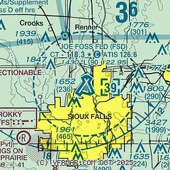
|
CAUTION: Diagram may not be current
 Download PDF
of official airport diagram from the FAA
| Airport distance calculator |
|---|
|
|
| Sunrise and sunset |
|---|
|
Times for 21-May-2026
| | Local
(UTC-5) | | Zulu
(UTC) |
|---|
| Morning civil twilight | | 05:23 | | 10:23 |
| Sunrise | | 05:57 | | 10:57 |
| Sunset | | 20:50 | | 01:50 |
| Evening civil twilight | | 21:24 | | 02:24 |
|
| Current date and time |
|---|
| Zulu (UTC) | 21-May-2026 21:05:13 |
|---|
| Local (UTC-5) | 21-May-2026 16:05:13 |
|---|
|
| METAR |
|---|
| KFSD | 212056Z 14013KT 10SM SCT049 19/07 A3006 RMK AO2 PK WND 16027/2018 SLP179 T01890072 58028
|
|
| TAF |
|---|
| KFSD | 211726Z 2118/2218 16012G20KT P6SM SCT040 BKN100 FM212300 14015G22KT P6SM BKN080 FM220200 13010G18KT P6SM BKN050 FM220700 11011G18KT P6SM OVC025 PROB30 2208/2210 5SM -SHRA OVC015 FM221000 11011G22KT 4SM -TSRA OVC009CB FM221400 11017G26KT 2SM TSRA OVC009CB
|
|
| NOTAMs |
|---|
NOTAMs are issued by the DoD/FAA and will open in a separate window not controlled by AirNav.
|
|


