FAA INFORMATION EFFECTIVE 16 APRIL 2026
Location
| FAA Identifier: | FXY |
| Lat/Long: | 43-14-05.1249N 093-37-26.7742W
43-14.085415N 093-37.446237W
43.2347569,-93.6241039
(estimated) |
| Elevation: | 1229.2 ft. / 374.7 m (surveyed) |
| Variation: | 03E (2000) |
| From city: | 2 miles S of FOREST CITY, IA |
| Time zone: | UTC -5 (UTC -6 during Standard Time) |
| Zip code: | 50436 |
Airport Operations
| Airport use: | Open to the public |
| Activation date: | 12/1958 |
| Control tower: | no |
| ARTCC: | MINNEAPOLIS CENTER |
| FSS: | FORT DODGE FLIGHT SERVICE STATION |
| NOTAMs facility: | FOD (NOTAM-D service available) |
| Attendance: | MON-FRI 0800-1730
AFT HR - 641-590-2127 OR AMGR. |
| Wind indicator: | lighted |
| Segmented circle: | no |
| Lights: | ACTVT REIL RWY 15 & 33; PAPI RWY 15 & 33; MIRL RWY 09/27 & 15/33 - CTAF. |
| Beacon: | white-green (lighted land airport)
Operates sunset to sunrise. |
Airport Communications
| CTAF/UNICOM: | 122.8 |
| WX AWOS-3: | 123.925 (641-581-2347) |
| WX ASOS at MCW (14 nm E): | 120.300 (641-255-0381) |
- COMMUNICATIONS PRVDD BY FORT DODGE RADIO ON FREQ 122.6 (MASON CITY RCO).
- APCH/DEP SVC PRVDD BY MINNEAPOLIS ARTCC ON FREQS 127.3/257.675 (MASON CITY RCAG).
Nearby radio navigation aids
| VOR radial/distance | | VOR name | | Freq | | Var |
|---|
| MCWr297/15.4 | | MASON CITY VOR/DME | | 114.90 | | 06E |
| AELr201/29.0 | | ALBERT LEA VOR/DME | | 109.80 | | 01E |
Airport Services
| Fuel available: | 100LL |
| Parking: | tiedowns |
| Airframe service: | MAJOR |
| Powerplant service: | MAJOR |
| Bottled oxygen: | NONE |
| Bulk oxygen: | NONE |
Runway Information
Runway 15/33
| Dimensions: | 5796 x 100 ft. / 1767 x 30 m |
| Surface: | asphalt, in good condition |
| Weight bearing capacity: | |
| Runway edge lights: | medium intensity |
| RUNWAY 15 | | RUNWAY 33 |
| Latitude: | 43-14.437933N | | 43-13.574120N |
| Longitude: | 093-37.616200W | | 093-37.061773W |
| Elevation: | 1206.7 ft. | | 1202.8 ft. |
| Traffic pattern: | left | | left |
| Runway heading: | 152 magnetic, 155 true | | 332 magnetic, 335 true |
| Displaced threshold: | 600 ft.
34:1 TO DTHR. | | no |
| Markings: | nonprecision, in good condition | | nonprecision, in good condition |
| Visual slope indicator: | 2-light PAPI on left (3.00 degrees glide path) | | 2-light PAPI on left (3.00 degrees glide path) |
| Runway end identifier lights: | yes | | yes |
| Touchdown point: | yes, no lights | | yes, no lights |
| Obstructions: | 39 ft. trees, 750 ft. from runway, 10 ft. left of centerline, 14:1 slope to clear | | 5 ft. fence, 315 ft. from runway, 28:1 slope to clear |
Runway 9/27
| Dimensions: | 2707 x 60 ft. / 825 x 18 m |
| Surface: | asphalt, in good condition |
| Weight bearing capacity: | | PCN 4 /F/C/X/U | | Single wheel: | 12.5 |
|
| Runway edge lights: | medium intensity |
| RUNWAY 9 | | RUNWAY 27 |
| Latitude: | 43-14.273830N | | 43-14.237507N |
| Longitude: | 093-37.979925W | | 093-37.372507W |
| Elevation: | 1229.2 ft. | | 1203.4 ft. |
| Traffic pattern: | left | | left |
| Runway heading: | 092 magnetic, 095 true | | 272 magnetic, 275 true |
| Markings: | basic, in fair condition | | basic, in fair condition |
| Touchdown point: | yes, no lights | | yes, no lights |
| Obstructions: | 34 ft. tree, 645 ft. from runway, 121 ft. left of centerline, 13:1 slope to clear | | 11 ft. tree, 231 ft. from runway, 49 ft. right of centerline, 2:1 slope to clear |
Airport Ownership and Management from official FAA records
| Ownership: | Publicly-owned |
| Owner: | CITY OF FOREST CITY
305 N. CLARK
FOREST CITY, IA 50436
Phone 641-585-3574 |
| Manager: | R. TRIMBLE
MUNICIPAL ARPT, 1842 330TH ST
FOREST CITY, IA 50436
Phone 641-581-2880
641-585-2166. |
Additional Remarks
| - | FOR CD CTC MINNEAPOLIS ARTCC AT 651-463-5588. |
Instrument Procedures
NOTE: All procedures below are presented as PDF files. If you need a reader for these files, you should download the free Adobe Reader.NOT FOR NAVIGATION. Please procure official charts for flight.
FAA instrument procedures published for use from 16 April 2026 at 0901Z to 14 May 2026 at 0900Z.
IAPs - Instrument Approach Procedures |
|---|
| RNAV (GPS) RWY 15 | |
download (260KB) |
| RNAV (GPS) RWY 33 | |
download (232KB) |
| VOR-A | |
download (203KB) |
| NOTE: Special Alternate Minimums apply | |
download (145KB) |
| NOTE: Special Take-Off Minimums/Departure Procedures apply | |
download (425KB) |
Other nearby airports with instrument procedures:
KMCW - Mason City Municipal Airport (14 nm E)
KAEL - Albert Lea Municipal Airport (29 nm NE)
KSBU - Blue Earth Municipal Airport (30 nm NW)
KAXA - Algona Municipal Airport (30 nm W)
KCAV - Clarion Municipal Airport (30 nm S)
|
|

Road maps at:
MapQuest
Bing
Google
| Aerial photo |
|---|
WARNING: Photo may not be current or correct
 Photo taken 02-Jul-2006
Do you have a better or more recent aerial photo of Forest City Municipal Airport/Trimble Field that you would like to share? If so, please send us your photo.
|
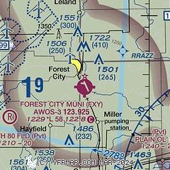
| Sectional chart |
|---|
|
| Airport distance calculator |
|---|
|
|
| Sunrise and sunset |
|---|
|
Times for 09-May-2026
| | Local
(UTC-5) | | Zulu
(UTC) |
|---|
| Morning civil twilight | | 05:26 | | 10:26 |
| Sunrise | | 05:58 | | 10:58 |
| Sunset | | 20:24 | | 01:24 |
| Evening civil twilight | | 20:56 | | 01:56 |
|
| Current date and time |
|---|
| Zulu (UTC) | 09-May-2026 09:54:39 |
|---|
| Local (UTC-5) | 09-May-2026 04:54:39 |
|---|
|
| METAR |
|---|
| KFXY | 090935Z AUTO 00000KT 10SM CLR 05/M01 A2965 RMK AO2
|
KMCW
14nm E | 090853Z AUTO 25006KT 10SM CLR 07/01 A2963 RMK AO2 SLP029 T00670011 58009
|
|
| TAF |
|---|
KMCW
14nm E | 090536Z 0906/1006 32009KT P6SM FEW120 FM091500 29014G25KT P6SM BKN080 FM100000 33015G24KT P6SM SCT200 FM100300 34007KT P6SM FEW220
|
|
| NOTAMs |
|---|
NOTAMs are issued by the DoD/FAA and will open in a separate window not controlled by AirNav.
|
|

