FAA INFORMATION EFFECTIVE 14 MAY 2026
Location
| FAA Identifier: | AEL |
| Lat/Long: | 43-40-52.7313N 093-22-05.3341W
43-40.878855N 093-22.088902W
43.6813143,-93.3681484
(estimated) |
| Elevation: | 1261 ft. / 384.4 m (surveyed) |
| Variation: | 01E (2010) |
| From city: | 3 miles N of ALBERT LEA, MN |
| Time zone: | UTC -5 (UTC -6 during Standard Time) |
| Zip code: | 56007 |
Airport Operations
| Airport use: | Open to the public |
| Activation date: | 03/1942 |
| Control tower: | no |
| ARTCC: | MINNEAPOLIS CENTER |
| FSS: | PRINCETON FLIGHT SERVICE STATION |
| NOTAMs facility: | AEL (NOTAM-D service available) |
| Attendance: | 0800-1700
FOR SVC AFT HRS CALL 507-826-3451. |
| Pattern altitude: | 2001 ft. MSL |
| Wind indicator: | lighted |
| Segmented circle: | no |
| Lights: | ACTVT ODALS RWY 17; REIL RWY 17 & 35; PAPI RWY 17 & 35; MIRL RWY 17/35 - CTAF. MIRL RWY 17/35 PRESET TO LOW SS-SR TO INCR INTST - CTAF. |
| Beacon: | white-green (lighted land airport)
Operates sunset to sunrise. |
| Landing fee: | yes, TIE DOWN FEE WAVED WITH FUEL PURCHASE. |
Airport Communications
| CTAF/UNICOM: | 123.0 |
| WX AWOS-3PT: | 119.575 (507-377-1583) |
| ROCHESTER APPROACH: | 119.8 |
| ROCHESTER DEPARTURE: | 119.8 |
| WX AWOS-3PT at AUM (19 nm E): | 120.675 (507-433-6667) |
- APCH/DEP SVC PRVDD BY MINNEAPOLIS ARTCC ON FREQS 132.35/307.3 (ROCHESTER RCAG) WHEN ROCHESTER APCH IS CLSD.
Nearby radio navigation aids
| VOR radial/distance | | VOR name | | Freq | | Var |
|---|
| AEL at field | | ALBERT LEA VOR/DME | | 109.80 | | 01E |
| FOWr178/31.4 | | HALFWAY VOR/DME | | 111.20 | | 02E |
| RSTr255/34.0 | | ROCHESTER VOR/DME | | 112.00 | | 05E |
| MCWr351/35.2 | | MASON CITY VOR/DME | | 114.90 | | 06E |
Airport Services
| Fuel available: | 100LL JET-A MOGAS
100LL:100LL & MOGAS FUEL AVBL 24 HR WITH CREDIT CARD. |
| Parking: | hangars and tiedowns |
| Airframe service: | MINOR |
| Powerplant service: | MINOR |
| Bottled oxygen: | NONE |
| Bulk oxygen: | NONE |
Runway Information
Runway 17/35
| Dimensions: | 5000 x 100 ft. / 1524 x 30 m |
| Surface: | asphalt, in good condition |
| Weight bearing capacity: | | Single wheel: | 19.0 | | Double wheel: | 29.0 |
|
| Runway edge lights: | medium intensity |
| RUNWAY 17 | | RUNWAY 35 |
| Latitude: | 43-41.264227N | | 43-40.458657N |
| Longitude: | 093-22.230305W | | 093-21.998160W |
| Elevation: | 1260.0 ft. | | 1261.0 ft. |
| Traffic pattern: | left | | left |
| Runway heading: | 167 magnetic, 168 true | | 347 magnetic, 348 true |
| Markings: | nonprecision, in good condition | | nonprecision, in good condition |
| Visual slope indicator: | 4-light PAPI on left (3.00 degrees glide path) | | 4-light PAPI on left (3.00 degrees glide path) |
| Approach lights: | ODALS: omnidirectional approach lighting system | | |
| Runway end identifier lights: | yes | | yes |
| Touchdown point: | yes, no lights | | yes, no lights |
| Obstructions: | none | | 7 ft. road, 332 ft. from runway, 499 ft. left and right of centerline, 18:1 slope to clear |
Runway 5/23
| Dimensions: | 2898 x 75 ft. / 883 x 23 m |
| Surface: | asphalt, in good condition |
| RUNWAY 5 | | RUNWAY 23 |
| Latitude: | 43-40.744883N | | 43-41.072918N |
| Longitude: | 093-22.283737W | | 093-21.806655W |
| Elevation: | 1252.8 ft. | | 1256.9 ft. |
| Traffic pattern: | left | | left |
| Runway heading: | 046 magnetic, 047 true | | 226 magnetic, 227 true |
| Markings: | nonprecision, in good condition | | nonprecision, in good condition |
| Runway end identifier lights: | no | | no |
| Touchdown point: | yes, no lights | | yes, no lights |
Airport Ownership and Management from official FAA records
| Ownership: | Publicly-owned |
| Owner: | CITY OF ALBERT LEA
221 E CLARK STREET
ALBERT LEA, MN 56007
Phone 507-377-4300 |
| Manager: | JIM HANSON
73950 275TH ST.
CLARKS GROVE, MN 56016
Phone 507-373-0608
EMAIL ADDRESS: JIMHANSON@DESKMEDIA.COM (ALL LOWER CASE) |
Additional Remarks
| A58-05 | RWY 05 HAS 5 FT BRUSH 79 FT FM THE RWY END AND 79 FT RIGHT. |
| - | TV TWR 9.5 NM SE. |
| - | GLIDERS & HELICOPTERS USE TURF PARALLEL TO RY 17/35 ON EAST SIDE & APPR AREA TO RY 23. |
| - | MULTIPLE TRANSITIONAL OBSTNS RY 05 & RY 35. |
| - | FOR CD CTC ROCHESTER APCH AT 507-424-8111. |
Instrument Procedures
NOTE: All procedures below are presented as PDF files. If you need a reader for these files, you should download the free Adobe Reader.NOT FOR NAVIGATION. Please procure official charts for flight.
FAA instrument procedures published for use from 14 May 2026 at 0901Z to 11 June 2026 at 0900Z.
IAPs - Instrument Approach Procedures |
|---|
| RNAV (GPS) RWY 17 | |
download (235KB) |
| RNAV (GPS) RWY 35 | |
download (229KB) |
| NOTE: Special Alternate Minimums apply **CHANGED** | |
download (176KB) |
| NOTE: Special Take-Off Minimums/Departure Procedures apply | |
download (156KB) |
Other nearby airports with instrument procedures:
KAUM - Austin Municipal Airport (19 nm E)
KACQ - Waseca Municipal Airport/Maynard Richard Stensrud Field (25 nm N)
KOWA - Owatonna Degner Regional Airport (27 nm N)
KFXY - Forest City Municipal Airport/Trimble Field (29 nm SW)
KTOB - Dodge Center Airport (31 nm NE)
|
|

Road maps at:
MapQuest
Bing
Google
| Aerial photo |
|---|
WARNING: Photo may not be current or correct
 Photo by Ed Wells
Photo taken 16-Jul-2006
from the South looking North
Photo by Ed Wells
Photo taken 16-Jul-2006
from the South looking North
Do you have a better or more recent aerial photo of Albert Lea Municipal Airport that you would like to share? If so, please send us your photo.
|
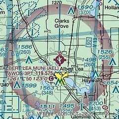
| Sectional chart |
|---|
|
| Airport distance calculator |
|---|
|
|
| Sunrise and sunset |
|---|
|
Times for 16-May-2026
| | Local
(UTC-5) | | Zulu
(UTC) |
|---|
| Morning civil twilight | | 05:15 | | 10:15 |
| Sunrise | | 05:48 | | 10:48 |
| Sunset | | 20:32 | | 01:32 |
| Evening civil twilight | | 21:05 | | 02:05 |
|
| Current date and time |
|---|
| Zulu (UTC) | 16-May-2026 16:55:33 |
|---|
| Local (UTC-5) | 16-May-2026 11:55:33 |
|---|
|
| METAR |
|---|
| KAEL | 161635Z AUTO VRB06KT 10SM CLR 25/02 A2987 RMK AO2 T02480024
|
KAUM
20nm E | 161635Z AUTO VRB05KT 10SM CLR 24/04 A2985 RMK AO2 T02440038
|
|
| TAF |
|---|
KMCW
32nm S | 161401Z 1614/1712 36006KT P6SM SKC FM162100 05005KT P6SM BKN230 FM170300 09008KT P6SM SCT170 FM170900 11010KT P6SM OVC045
|
KRST
40nm E | 161120Z 1612/1712 28008KT P6SM FEW100 FM161500 32008KT P6SM FEW250 FM170100 02007KT P6SM FEW150 FM170700 07007KT P6SM BKN100
|
|
| NOTAMs |
|---|
NOTAMs are issued by the DoD/FAA and will open in a separate window not controlled by AirNav.
|
|

