FAA INFORMATION EFFECTIVE 14 MAY 2026
Location
| FAA Identifier: | HDL |
| Lat/Long: | 31-21-50.9000N 085-18-45.1000W
31-21.848333N 085-18.751667W
31.3641389,-85.3125278
(estimated) |
| Elevation: | 358.6 ft. / 109.3 m (surveyed) |
| Variation: | 03W (2005) |
| From city: | 2 miles NE of HEADLAND, AL |
| Time zone: | UTC -5 (UTC -6 during Standard Time) |
| Zip code: | 36345 |
Airport Operations
| Airport use: | Open to the public |
| Activation date: | 01/1947 |
| Control tower: | no |
| ARTCC: | JACKSONVILLE CENTER |
| FSS: | ANNISTON FLIGHT SERVICE STATION |
| NOTAMs facility: | ANB (NOTAM-D service available) |
| Attendance: | MON - FRI 0800 - 1700, ALL SAT - SUN UNATTENDED |
| Wind indicator: | lighted |
| Segmented circle: | yes |
| Lights: | ACTVT REIL RWY 09 & 27; PAPI RWY 09 & 27; MIRL RWY 09/27 - CTAF. |
| Beacon: | white-green (lighted land airport)
Operates sunset to sunrise. |
Airport Communications
| CTAF: | 122.9 |
| WX AWOS-3PT: | 119.575 (334-693-0508) |
| CAIRNS APPROACH: | 125.4 |
| CAIRNS DEPARTURE: | 125.4 |
| WX ASOS at DHN (7 nm W): | PHONE 334-983-5999 |
- APCH/DEP SVC PRVDD BY JACKSONVILLE ARTCC ON FREQS 134.3/322.55 (DOTHAN RCAG) WHEN CAIRNS APCH/DEP CLSD.
Nearby radio navigation aids
| VOR radial/distance | | VOR name | | Freq | | Var |
|---|
| RRSr050/7.7 | | WIREGRASS VORTAC | | 111.60 | | 02E |
| HEYr095/(17.4) | | HANCHEY VOR | | 110.60 | | 03W |
| OZRr078/22.0 | | CAIRNS VOR/DME | | 111.20 | | 03W |
| EDNr085/(30.5) | | ENTERPRISE VOR | | 116.60 | | 03W |
| MAIr344/36.0 | | MARIANNA VORTAC | | 114.00 | | 00E |
| EUFr193/36.4 | | EUFAULA VOR/DME | | 109.20 | | 02E |
| NDB name | | Hdg/Dist | | Freq | | Var | | ID |
|---|
| BOLL WEEVIL | | 091/34.3 | | 352 | | 03W | | BVG | -... ...- --. |
Airport Services
| Fuel available: | 100LL JET-A
100LL:FUEL 24 HR CREDIT CARD SVC AVBL. |
| Parking: | tiedowns |
| Airframe service: | MAJOR |
| Powerplant service: | MAJOR |
| Bottled oxygen: | NONE |
| Bulk oxygen: | NONE |
Runway Information
Runway 9/27
| Dimensions: | 5002 x 80 ft. / 1525 x 24 m |
| Surface: | asphalt, in good condition |
| Weight bearing capacity: | |
| Runway edge lights: | medium intensity |
| RUNWAY 9 | | RUNWAY 27 |
| Latitude: | 31-21.831415N | | 31-21.818193N |
| Longitude: | 085-19.144578W | | 085-18.183712W |
| Elevation: | 353.8 ft. | | 355.1 ft. |
| Traffic pattern: | left | | left |
| Runway heading: | 094 magnetic, 091 true | | 274 magnetic, 271 true |
| Markings: | nonprecision, in good condition | | nonprecision, in good condition |
| Visual slope indicator: | 2-light PAPI on left (3.00 degrees glide path) | | 2-light PAPI on left (3.50 degrees glide path) |
| Runway end identifier lights: | yes | | yes |
| Touchdown point: | yes, no lights | | yes, no lights |
| Obstructions: | 49 ft. tree, 1062 ft. from runway, 179 ft. right of centerline, 17:1 slope to clear | | 16 ft. tree, 445 ft. from runway, 1513 ft. left of centerline, 15:1 slope to clear |
Runway 17/35
| Dimensions: | 2865 x 162 ft. / 873 x 49 m |
| Surface: | turf, in good condition |
| RUNWAY 17 | | RUNWAY 35 |
| Latitude: | 31-22.124190N | | 31-21.653742N |
| Longitude: | 085-18.928882W | | 085-18.876705W |
| Elevation: | 355.7 ft. | | 356.2 ft. |
| Traffic pattern: | left | | left |
| Runway heading: | 178 magnetic, 175 true | | 358 magnetic, 355 true |
| Markings: | basic, in good condition | | basic, in good condition |
| Touchdown point: | yes, no lights | | yes, no lights |
| Obstructions: | 25 ft. tree, 571 ft. from runway, 90 ft. left of centerline, 22:1 slope to clear | | 63 ft. tree, 1379 ft. from runway, 261 ft. left of centerline, 21:1 slope to clear |
Airport Ownership and Management from official FAA records
| Ownership: | Publicly-owned |
| Owner: | CITY OF HEADLAND
9 PARK STREET
HEADLAND, AL 36345
Phone 334-693-3365 |
| Manager: | JOSH MOORE
230 AIRPORT DR.
HEADLAND, AL 36345
Phone 334-693-9415 |
Additional Remarks
| A30A-35 | FARM EQPT AND ACFT PARKED CLOSE TO RWY THR. |
| - | FOR CD CTC CAIRNS APCH AT 334-255-8402, WHEN APCH CLSD CTC JACKSONVILLE ARTCC AT 904-845-1592. |
Instrument Procedures
NOTE: All procedures below are presented as PDF files. If you need a reader for these files, you should download the free Adobe Reader.NOT FOR NAVIGATION. Please procure official charts for flight.
FAA instrument procedures published for use from 14 May 2026 at 0901Z to 11 June 2026 at 0900Z.
IAPs - Instrument Approach Procedures |
|---|
| RNAV (GPS) RWY 09 | |
download (193KB) |
| RNAV (GPS) RWY 27 | |
download (184KB) |
| NOTE: Special Alternate Minimums apply | |
download (155KB) |
| NOTE: Special Take-Off Minimums/Departure Procedures apply | |
download (489KB) |
Other nearby airports with instrument procedures:
KDHN - Dothan Regional Airport (7 nm W)
71J - Ozark/Blackwell Field Airport (16 nm W)
KHEY - Hanchey Army Heliport (Fort Rucker) (17 nm W)
KOZR - Cairns Army Airfield (Fort Rucker) (21 nm W)
KBIJ - Early County Airport (21 nm E)
|
|

Road maps at:
MapQuest
Bing
Google
| Aerial photo |
|---|
WARNING: Photo may not be current or correct
 Photo taken 21-Feb-2012
looking northwest.
Photo taken 21-Feb-2012
looking northwest.
Do you have a better or more recent aerial photo of Headland Municipal Airport that you would like to share? If so, please send us your photo.
|
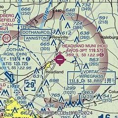
| Sectional chart |
|---|
|
| Airport distance calculator |
|---|
|
|
| Sunrise and sunset |
|---|
|
Times for 07-Jun-2026
| | Local
(UTC-5) | | Zulu
(UTC) |
|---|
| Morning civil twilight | | 05:10 | | 10:10 |
| Sunrise | | 05:37 | | 10:37 |
| Sunset | | 19:43 | | 00:43 |
| Evening civil twilight | | 20:11 | | 01:11 |
|
| Current date and time |
|---|
| Zulu (UTC) | 08-Jun-2026 00:11:39 |
|---|
| Local (UTC-5) | 07-Jun-2026 19:11:39 |
|---|
|
| METAR |
|---|
KDHN
8nm W | 072353Z 23004KT 10SM CLR 28/21 A3002 RMK AO1 SLP159 T02830206 10306 20283 53002 $
|
KHEY
18nm W | 072355Z AUTO 00000KT 9SM CLR 29/22 A2997 RMK AO2 SLP148 T02850222 10307 20285 53003 $
|
|
| TAF |
|---|
KDHN
8nm W | 071728Z 0718/0818 16009KT P6SM SCT030 BKN250 FM072200 VRB06KT P6SM VCSH SCT050 BKN100 FM080300 VRB02KT P6SM FEW030 BKN150
|
|
| NOTAMs |
|---|
NOTAMs are issued by the DoD/FAA and will open in a separate window not controlled by AirNav.
|
|

