FAA INFORMATION EFFECTIVE 14 MAY 2026
Location
| FAA Identifier: | HEI |
| Lat/Long: | 46-00-53.6000N 102-39-21.6000W
46-00.893333N 102-39.360000W
46.0148889,-102.6560000
(estimated) |
| Elevation: | 2705.8 ft. / 824.7 m (surveyed) |
| Variation: | 08E (2010) |
| From city: | 1 mile NW of HETTINGER, ND |
| Time zone: | UTC -6 (UTC -7 during Standard Time) |
| Zip code: | 58639 |
Airport Operations
| Airport use: | Open to the public |
| Activation date: | 01/1947 |
| Control tower: | no |
| ARTCC: | MINNEAPOLIS CENTER |
| FSS: | GRAND FORKS FLIGHT SERVICE STATION |
| NOTAMs facility: | HEI (NOTAM-D service available) |
| Attendance: | MON-SAT 0700-1700
FOR ATTENDANT DUSK-DAWN CALL (701) 928-0615. |
| Wind indicator: | lighted, WINDSOCKS LOCATED EACH END OF RWY 12/30. |
| Segmented circle: | yes |
| Lights: | PAPI RWY 12 & 30; MIRL RWY 12/30 OPR CONSLY FM DUSK TO 2200; AFT 2200 TO ACTVT PAPI RWY 12 & 30; MIRL RWY 12/30 - CTAF. |
| Beacon: | white-green (lighted land airport)
Operates sunset to sunrise. |
Airport Communications
| CTAF/UNICOM: | 122.8 |
| WX ASOS: | 119.925 (701-937-6530) |
- APCH/DEP SVC PRVDD BY MINNEAPOLIS ARTCC ON FREQS 124.25/236.825 (DICKINSON RCAG).
Nearby radio navigation aids
| VOR radial/distance | | VOR name | | Freq | | Var |
|---|
| LEMr278/(23.7) | | LEMMON VOR | | 111.40 | | 06E |
Airport Services
| Fuel available: | 100LL JET-A
100LL:24-HR SELF- SERVICE FUEL AVBL WITH CREDIT CARD. |
| Parking: | hangars and tiedowns |
| Airframe service: | MAJOR |
| Powerplant service: | MAJOR |
| Bottled oxygen: | NONE |
| Bulk oxygen: | NONE |
Runway Information
Runway 12/30
| Dimensions: | 4652 x 75 ft. / 1418 x 23 m |
| Surface: | asphalt, in good condition |
| Weight bearing capacity: | |
| Runway edge lights: | medium intensity |
| RUNWAY 12 | | RUNWAY 30 |
| Latitude: | 46-01.215085N | | 46-00.668392N |
| Longitude: | 102-39.721257W | | 102-38.952675W |
| Elevation: | 2705.3 ft. | | 2698.9 ft. |
| Traffic pattern: | left | | left |
| Runway heading: | 128 magnetic, 136 true | | 308 magnetic, 316 true |
| Markings: | nonprecision, in good condition | | nonprecision, in good condition |
| Visual slope indicator: | 2-light PAPI on left (3.00 degrees glide path) | | 2-light PAPI on left (3.00 degrees glide path) |
| Runway end identifier lights: | no | | no |
| Touchdown point: | yes, no lights | | yes, no lights |
Runway 17/35
| Dimensions: | 2020 x 110 ft. / 616 x 34 m |
| Surface: | turf, in good condition |
| RUNWAY 17 | | RUNWAY 35 |
| Latitude: | 46-00.947228N | | 46-00.620358N |
| Longitude: | 102-39.369622W | | 102-39.454943W |
| Elevation: | 2702.4 ft. | | 2687.6 ft. |
| Traffic pattern: | left | | left |
| Runway heading: | 182 magnetic, 190 true | | 002 magnetic, 010 true |
| Runway end identifier lights: | no | | no |
| Touchdown point: | yes, no lights | | yes, no lights |
Airport Ownership and Management from official FAA records
| Ownership: | Publicly-owned |
| Owner: | ADAMS CO ARPT AUTH
BOX 429
HETTINGER, ND 58639
Phone 701-567-2069 |
| Manager: | JAY B. LINDQUIST
PO BOX 429
HETTINGER, ND 58639
Phone 701-567-2069
ADDL CTC AFT HRS CHARLES LINDQUIST 701-567-4469 OR 701-928-0615. |
Additional Remarks
| - | CFM WINTER COND RWY 17/35 CALL AMGR 701-567-2069/4469 OR 701-928-0615. |
| - | TWYS ILLUMINATED WITH REFLECTORS FOR NIGHTIME USE. |
| - | DEER ON & INVOF ARPT. |
| - | FOR CD CTC MINNEAPOLIS ARTCC AT 651-463-5588. |
| - | WIND TURBINES LCTD APRXLY 13000 FT NE OF ARPT. |
Instrument Procedures
NOTE: All procedures below are presented as PDF files. If you need a reader for these files, you should download the free Adobe Reader.NOT FOR NAVIGATION. Please procure official charts for flight.
FAA instrument procedures published for use from 14 May 2026 at 0901Z to 11 June 2026 at 0900Z.
IAPs - Instrument Approach Procedures |
|---|
| RNAV (GPS) RWY 12 **CHANGED** | |
download (218KB) |
| RNAV (GPS) RWY 30 **CHANGED** | |
download (207KB) |
| NOTE: Special Alternate Minimums apply | |
download (160KB) |
| NOTE: Special Take-Off Minimums/Departure Procedures apply | |
download (406KB) |
Other nearby airports with instrument procedures:
KLEM - Lemmon Municipal Airport (24 nm E)
3P3 - Mott Municipal Airport (25 nm NE)
KBWW - Bowman Regional Airport (28 nm W)
KDIK - Dickinson/Theodore Roosevelt Regional Airport (48 nm N)
D57 - Glen Ullin Regional Airport (58 nm NE)
|
|

Road maps at:
MapQuest
Bing
Google
| Aerial photo |
|---|
WARNING: Photo may not be current or correct

Do you have a better or more recent aerial photo of Hettinger/JB Lindquist Regional Airport that you would like to share? If so, please send us your photo.
|
| Sectional chart |
|---|
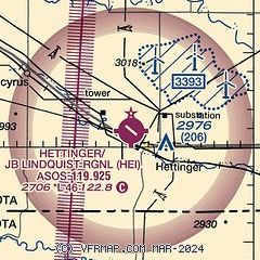
|
| Airport distance calculator |
|---|
|
|
| Sunrise and sunset |
|---|
|
Times for 07-Jun-2026
| | Local
(UTC-6) | | Zulu
(UTC) |
|---|
| Morning civil twilight | | 04:23 | | 10:23 |
| Sunrise | | 05:01 | | 11:01 |
| Sunset | | 20:37 | | 02:37 |
| Evening civil twilight | | 21:15 | | 03:15 |
|
| Current date and time |
|---|
| Zulu (UTC) | 07-Jun-2026 16:06:59 |
|---|
| Local (UTC-6) | 07-Jun-2026 10:06:59 |
|---|
|
| METAR |
|---|
| KHEI | 071553Z AUTO 15015KT 10SM CLR 27/15 A2954 RMK AO2 SLP976 T02670150
|
|
| TAF |
|---|
KDIK
47nm N | 071126Z 0712/0812 14008KT P6SM FEW100 SCT250 FM071800 17016G24KT P6SM SCT250 FM080000 28010KT P6SM VCTS SCT080CB OVC120 PROB30 0801/0805 VRB20G40KT 3SM +TSRA BR BKN040 OVC080CB FM080500 31015KT P6SM OVC080 FM081000 28011KT P6SM SCT250
|
|
| NOTAMs |
|---|
NOTAMs are issued by the DoD/FAA and will open in a separate window not controlled by AirNav.
|
|

