FAA INFORMATION EFFECTIVE 11 JUNE 2026
Location
| FAA Identifier: | VLD |
| Lat/Long: | 30-46-53.2720N 083-16-33.4980W
30-46.887867N 083-16.558300W
30.7814644,-83.2759717
(estimated) |
| Elevation: | 203.1 ft. / 61.9 m (surveyed) |
| Variation: | 05W (2010) |
| From city: | 3 miles S of VALDOSTA, GA |
| Time zone: | UTC -4 (UTC -5 during Standard Time) |
| Zip code: | 31601 |
Airport Operations
| Airport use: | Open to the public |
| Activation date: | 04/1940 |
| Control tower: | yes |
| ARTCC: | JACKSONVILLE CENTER |
| FSS: | MACON FLIGHT SERVICE STATION |
| NOTAMs facility: | VLD (NOTAM-D service available) |
| Attendance: | 0600-2200
CONTACT FBO 229-242-3175. |
| Wind indicator: | lighted |
| Segmented circle: | yes |
| Lights: | WHEN ATCT CLSD ACTVT MALSR RWY 36; REIL RWY 18; PAPI RWY 18 & 36; HIRL RWY 18/36 - CTAF. REIL RWY 04/22; PAPI RWY 04 & 22; MIRL RWY 04/22 UNAVBL WHEN ATCT CLSD. |
| Beacon: | white-green (lighted land airport)
Operates sunset to sunrise. |
| Fire and rescue: | ARFF index A |
| Airline operations: | CLSD TO UNSKED ACR OPNS WITH MORE THAN 30 PSGR SEATS EXCP 24 HR PPR CALL AMGR 229-333-1833. |
Airport Communications
| CTAF: | 128.35 |
| UNICOM: | 122.95 |
| WX ASOS: | 126.225 (229-213-0843) |
| VALDOSTA GROUND: | 121.7 [0700-2200] |
| VALDOSTA TOWER: | 128.35 [0700-2200] |
| VALDOSTA APPROACH: | 126.6 |
| VALDOSTA DEPARTURE: | 126.6 |
| IC: | 126.6 |
- APCH/DEP SVC PRVDD BY JACKSONVILLE ARTCC ON FREQS 133.7/323.3(VALDOSTA RCAG) WHEN VALDOSTA APCH CTL CLSD.
Nearby radio navigation aids
| VOR radial/distance | | VOR name | | Freq | | Var |
|---|
| OTK at field | | VALDOSTA VOR/DME | | 114.80 | | 02W |
| GEFr061/29.6 | | GREENVILLE VORTAC | | 113.65 | | 01E |
Airport Services
| Fuel available: | 100LL JET-A1+ |
| Parking: | hangars and tiedowns |
| Airframe service: | MAJOR |
| Powerplant service: | MAJOR |
| Bottled oxygen: | NONE |
| Bulk oxygen: | NONE |
Runway Information
Runway 18/36
| Dimensions: | 8003 x 150 ft. / 2439 x 46 m |
| Surface: | asphalt/grooved, in good condition |
| Weight bearing capacity: | | Single wheel: | 101.0 | | Double wheel: | 169.0 | | Double tandem: | 283.0 |
|
| Runway edge lights: | high intensity |
| RUNWAY 18 | | RUNWAY 36 |
| Latitude: | 30-47.427777N | | 30-46.124625N |
| Longitude: | 083-16.513015W | | 083-16.269137W |
| Elevation: | 196.5 ft. | | 199.7 ft. |
| Traffic pattern: | left | | left |
| Runway heading: | 176 magnetic, 171 true | | 356 magnetic, 351 true |
| Declared distances: | TORA:8002 TODA:8002 ASDA:8002 LDA:8002 | | TORA:8002 TODA:8002 ASDA:8002 LDA:8002 |
| Markings: | precision, in good condition | | precision, in good condition |
| Visual slope indicator: | 4-light PAPI on left (3.00 degrees glide path) | | 4-light PAPI on left (3.00 degrees glide path) |
| Approach lights: | | | MALSR: 1,400 foot medium intensity approach lighting system with runway alignment indicator lights |
| Runway end identifier lights: | yes | | no |
| Touchdown point: | yes, no lights | | yes, no lights |
| Instrument approach: | | | ILS |
| Obstructions: | 55 ft. trees, 1875 ft. from runway, 60 ft. right of centerline, 25:1 slope to clear | | 56 ft. trees, 3000 ft. from runway, 875 ft. left of centerline |
Runway 4/22
| Dimensions: | 5598 x 100 ft. / 1706 x 30 m |
| Surface: | asphalt/grooved, in fair condition |
| Weight bearing capacity: | | Single wheel: | 77.0 | | Double wheel: | 124.0 | | Double tandem: | 210.0 |
|
| Runway edge lights: | medium intensity |
| RUNWAY 4 | | RUNWAY 22 |
| Latitude: | 30-46.673147N | | 30-47.421837N |
| Longitude: | 083-17.110397W | | 083-16.484362W |
| Elevation: | 198.9 ft. | | 196.3 ft. |
| Traffic pattern: | left | | left |
| Runway heading: | 041 magnetic, 036 true | | 221 magnetic, 216 true |
| Declared distances: | TORA:5598 TODA:5598 ASDA:5598 LDA:5598 | | TORA:5598 TODA:5598 ASDA:5598 LDA:5598 |
| Markings: | nonprecision, in fair condition | | nonprecision, in fair condition |
| Visual slope indicator: | 4-light PAPI on left (3.25 degrees glide path)
PAPI UNUSBL BYD 7 DEG LEFT OF CNTRLN. | | 4-light PAPI on left (3.25 degrees glide path) |
| Runway end identifier lights: | yes | | yes |
| Touchdown point: | yes, no lights | | yes, no lights |
| Obstructions: | 7 ft. trees, 300 ft. from runway, 70 ft. right of centerline, 14:1 slope to clear | | 48 ft. trees, 1175 ft. from runway, 320 ft. left of centerline, 20:1 slope to clear |
Airport Ownership and Management from official FAA records
| Ownership: | Publicly-owned |
| Owner: | VALDOSTA-LOWNDES CTY APT AUTH
1750 ARPT RD, SUITE 1
VALDOSTA, GA 31601
Phone 229-333-1833 |
| Manager: | TIM HOOD
1750 AIRPORT RD, SUITE 1
VALDOSTA, GA 31601
Phone 229-333-1833 |
Additional Remarks
| A39-18/36 | PCR VALUE: 400/F/B/X/T |
| A39-04/22 | PCR VALUE: 290/F/B/X/T |
| - | RWY 04/22 HAS 10 FT PAVED SHOULDERS WITH VEGETATION. |
| - | PILOTS MUST SUP OWN TIE-DOWN ROPES. |
Instrument Procedures
NOTE: All procedures below are presented as PDF files. If you need a reader for these files, you should download the free Adobe Reader.NOT FOR NAVIGATION. Please procure official charts for flight.
FAA instrument procedures published for use from 11 June 2026 at 0901Z to 09 July 2026 at 0900z.
IAPs - Instrument Approach Procedures |
|---|
| ILS OR LOC RWY 36 | |
download (277KB) |
| RNAV (GPS) RWY 04 | |
download (209KB) |
| RNAV (GPS) RWY 18 | |
download (214KB) |
| RNAV (GPS) RWY 36 | |
download (225KB) |
| VOR RWY 18 | |
download (167KB) |
| VOR RWY 36 | |
download (225KB) |
| NOTE: Special Alternate Minimums apply | |
download (158KB) |
| NOTE: Special Take-Off Minimums/Departure Procedures apply | |
download (506KB) |
Other nearby airports with instrument procedures:
KVAD - Moody Air Force Base (12 nm N)
4J5 - Quitman Brooks County Airport (16 nm W)
15J - Cook County Airport (23 nm NW)
4J2 - Berrien County Airport (26 nm N)
KHOE - Homerville Airport (31 nm NE)
|
|

Road maps at:
MapQuest
Bing
Google
| Aerial photo |
|---|
WARNING: Photo may not be current or correct

Do you have a better or more recent aerial photo of Valdosta Regional Airport that you would like to share? If so, please send us your photo.
|
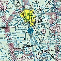
| Sectional chart |
|---|
|
 Download PDF
of official airport diagram from the FAA
| Airport distance calculator |
|---|
|
|
| Sunrise and sunset |
|---|
|
Times for 13-Jun-2026
| | Local
(UTC-4) | | Zulu
(UTC) |
|---|
| Morning civil twilight | | 06:03 | | 10:03 |
| Sunrise | | 06:30 | | 10:30 |
| Sunset | | 20:36 | | 00:36 |
| Evening civil twilight | | 21:03 | | 01:03 |
|
| Current date and time |
|---|
| Zulu (UTC) | 13-Jun-2026 04:41:12 |
|---|
| Local (UTC-4) | 13-Jun-2026 00:41:12 |
|---|
|
| METAR |
|---|
| KVLD | 130353Z 00000KT 10SM CLR 27/23 A2998 RMK AO2 SLP158 T02720228
|
KVAD
12nm N | 130255Z 27005KT 10SM FEW060 SCT090 SCT100 BKN150 29/23 A2999 RMK AO2A SLP155 T02880227 52018 $
|
|
| TAF |
|---|
| KVLD | 121735Z 1218/1318 VRB04KT P6SM SCT060 FM130000 24003KT P6SM FEW050 FM131200 30003KT P6SM SCT070
|
KVAD
12nm N | 130000Z 1300/1406 26006KT 9999 SCT065 SCT250 QNH2994INS BECMG 1307/1308 26006KT 9999 SCT065 SCT140 BKN250 QNH2997INS BECMG 1317/1318 22006KT 9999 BKN065 BKN250 QNH2993INS TEMPO 1318/1320 VRB15G25KT 4800 -TSRA BKN065CB TX36/1319Z TN25/1312Z LAST NO AMDS AFT 1300 NEXT 1316
|
|
| NOTAMs |
|---|
NOTAMs are issued by the DoD/FAA and will open in a separate window not controlled by AirNav.
|
|


